
Christmas Eve & Christmas Day Mostly Dry & Mild Rain Arrives Tuesday Night Pattern Change Process Begins Later Next Week

Christmas Eve & Christmas Day Mostly Dry & Mild Rain Arrives Tuesday Night
Pattern Change Process Begins Later Next Week

We have arrived at the Christmas holiday weekend and for the most part we have no issues. On the satellite and radar we have clouds and some showers well to the west in Western NY and Western Pennsylvania but the bulk of that moisture is going to pass to our west and north tonight into Sunday morning. There is a weak warm front that extends southward from the Great Lakes to the coast and ahead of it today we will have sky conditions that will range from cloudy to partly sunny with most highs in the 40s.
SATELLITE WITH LIGHTNING STRIKES

WEATHER RADAR

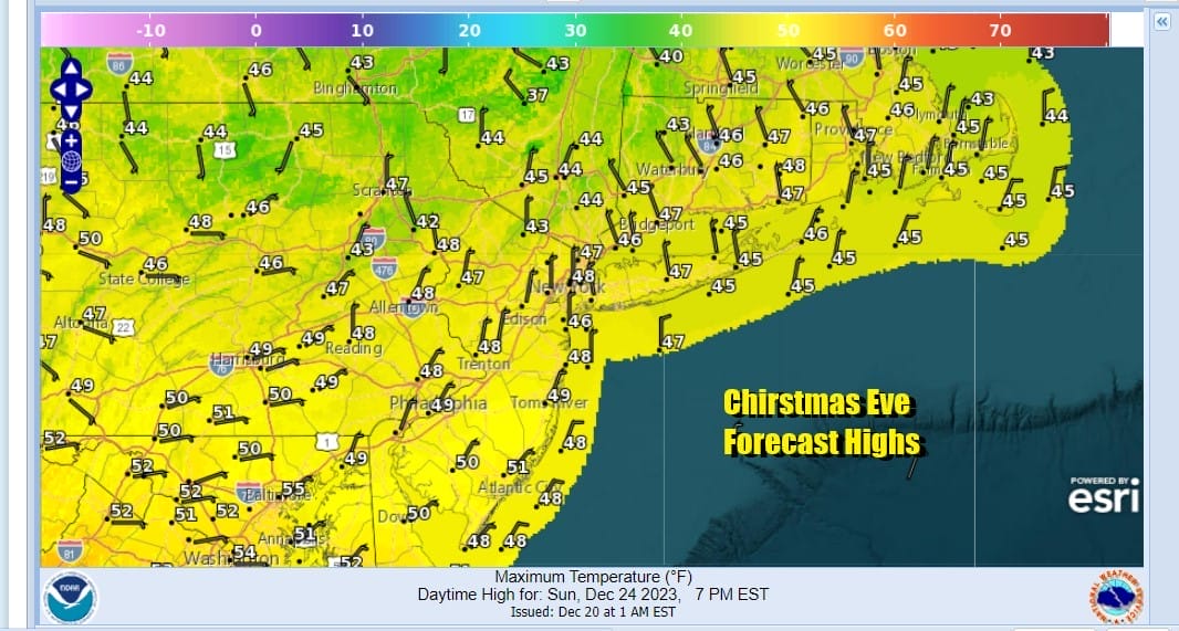
Tonight it is about the warm front moving through so look for clouds, temperatures that won’t be as low as past nights, and the risk there could be some scattered showers overnight into early Sunday morning. Temperatures overnight will be in the 30s to around 40. Once we get past Sunday morning clouds will attempt to give way to some breaks of sunshine so we will call it cloudy to partly sunny. Christmas Eve highs will be in the 40s to around 50 degrees.
We don’t see any issues overnight Sunday into Christmas Day in case you are travelling around and Christmas Day itself will be a warm day with clouds and some sunshine. Highs will reach into the 50s just about everywhere. Im leaving any mention of a passing shower out of the forecast for both Sunday afternoon and Monday.

Looking ahead to Tuesday, Boxing Day and beyond, we see weather conditions deteriorating as low pressure in the Mississippi Valley turns northwest and weakens while a cold front pushes to the coast. Another low will develop on the front in Coastal North Carolina and run northeastward. This system coming in slower than forecast a few days ago and that probably means that the daytimg Tuesday will be mostly dry with rain arriving late in the day or Tuesday night from southwest to northeast. Highs Tuesday will be in the 50s.

We will likely see rain for Wednesday with highs in the mid 50s to around 60 degrees. However once this storm system is done we are going begin the process of a wholesale pattern change across North America. This process will take about a week to complete but when it is done we will be in a cold winter pattern that is likely to hold into at least the first 10 days to 2 weeks of January. For snow lovers the question is a more difficult one to answer as that is dependent on storm systems, moisture, tracks etc.

Over the last 2 weeks the connection to cold air in Canada has been limited and mostly over the Northeast and Mid Alantic in quick shots. This is changing next week to create a strengthening connection to a cold flow from Northern Canada. We will also see the flow in the Pacific change from the firehose jet from Tokyo to San Francisco to one that doesn’t flood the US with Pacific air. Climate models suggest this pattern may be the primary pattern going forward. Enjoy your Christmas Eve and Christmas Day and a Merry Christmas to all!
BE SURE TO DOWNLOAD THE FREE METEOROLOGIST JOE CIOFFI WEATHER APP &
ANGRY BEN’S FREE WEATHER APP “THE ANGRY WEATHERMAN!
MANY THANKS TO TROPICAL TIDBITS FOR THE USE OF MAPS
Please note that with regards to any severe weather, tropical storms, or hurricanes, should a storm be threatening, please consult your local National Weather Service office or your local government officials about what action you should be taking to protect life and property.
(Amazon is an affilate of Meteorologist Joe Cioffi & earns commissions on sales.)


