
Chilly Nights Ahead
Chilly Nights Ahead
We have two chilly nights ahead of us with cool air from Eastern Canada continuing to push southward from Northern New England. Clouds on the satellite loop continue to push southward. We are set up for clear skies and chilly Sunday morning lows in the 40s in many locations.
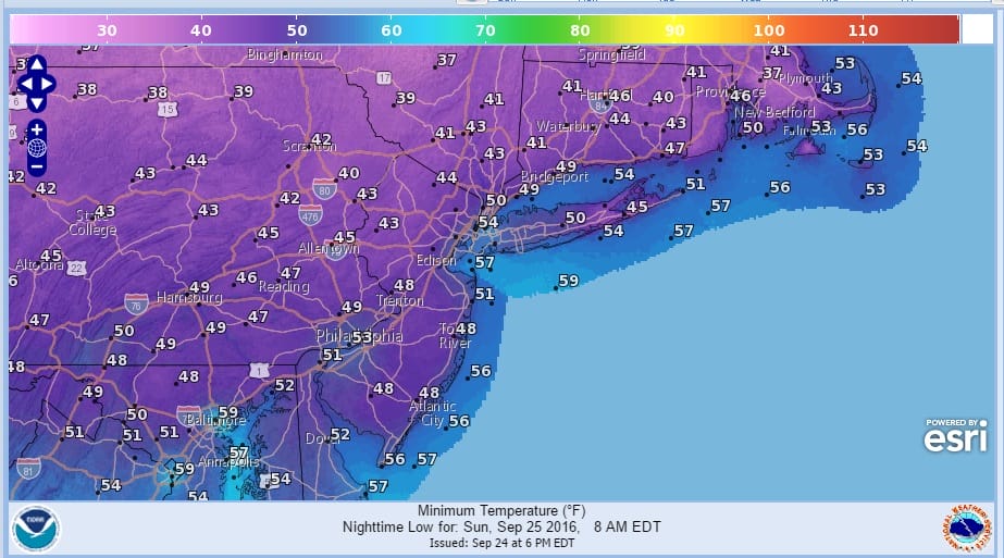
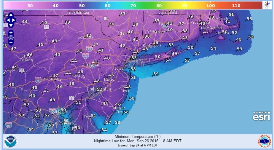
Sunday we will see lots of sunshine but highs won’t be much out of the 60s in most places. This sets us up for a very chilly Sunday night with clear skies. By Monday morning most lows again will be in the 40s but there will be a large area of 30s away from the coastline. Most of the frost that could develop should still be well north and west of the coast.
As we look to the west on the satellite loop we can see clouds and the next storm system and cold front in the Northern Rockies. That front starts its approach on Monday with arriving clouds and highs in the 60s. We should see rain from this system late Monday night and for at least part of Tuesday.


Models are changing for the second half of the week as they seem to be going back to the idea of energy being forced to the coast. If this is the case we may have another shot of rain for later Wednesday into Thursday. We will continue to watch model trends for the mid and late week period.

WINTER WEATHER OUTLOOK VIDEOS
In case you missed them I’ve been previewing the upcoming winter in a series of posts and videos. Here are the first 2. More will be coming along. Links to the latest posts are below.
PENNSYLVANIA
NEW JERSEY
LONG ISLAND AND NEARBY
WINTER 2016-2017 PART 3 NEW JERSEY
WINTER 2016-2017 PART 1 OCEAN WATER TEMPERATURES
WINTER 2016-2017 PART 2 ARCTIC SEA ICE AND SIBERIAN SNOW COVER
FiOS1 News Weather Forecast For Long Island
FiOS1 News Weather Forecast For New Jersey
FiOS1 News Weather Forecast For Hudson Valley
NATIONAL WEATHER SERVICE SNOW FORECASTS
LATEST JOESTRADAMUS ON THE LONG RANGE

Weather App

Don’t be without Meteorologist Joe Cioffi’s weather app. It is really a meteorologist app because you get my forecasts and my analysis and not some automated computer generated forecast based on the GFS model. This is why your app forecast changes every 6 hours. It is model driven with no human input at all. It gives you an icon, a temperature and no insight whatsoever.
It is a complete weather app to suit your forecast needs. All the weather information you need is right on your phone. Android or I-phone, use it to keep track of all the latest weather information and forecasts. This weather app is also free of advertising so you don’t have to worry about security issues with your device. An accurate forecast and no worries that your device is being compromised.
Use it in conjunction with my website and my facebook and twitter and you have complete weather coverage of all the latest weather and the long range outlook. The website has been redone and upgraded. Its easy to use and everything is archived so you can see how well Joe does or doesn’t do when it comes to forecasts and outlooks.
Just click on the google play button or the apple store button on the sidebar for my app which is on My Weather Concierge. Download the app for free. Subscribe to my forecasts on an ad free environment for just 99 cents a month.
Get my forecasts in the palm of your hand for less than the cost of a cup of Joe!

MENTION JOE CIOFFI AND GET A 5% DISCOUNT


