
Winter 2016-2017 Eastern Pennsylvania
Winter 2016-2017 Eastern Pennsylvania

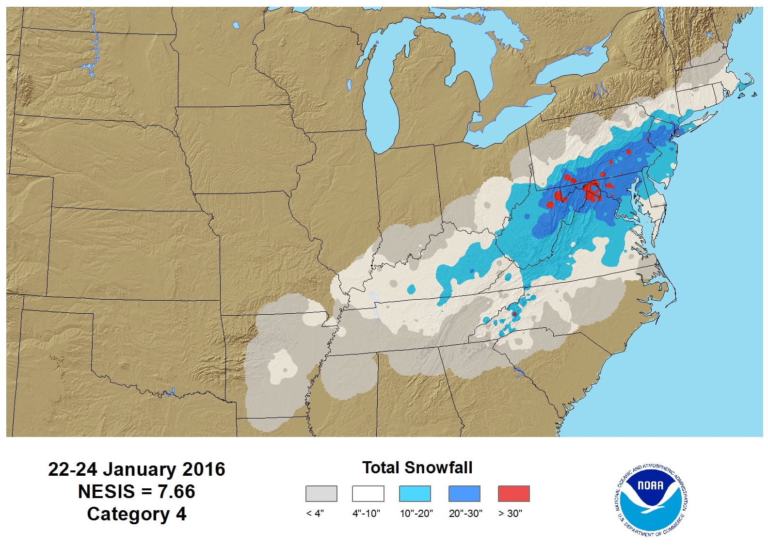
When it comes to annual snowfall in Pennsylvania there are three worlds. First is the world of Southeastern Pennsylvania extended westward to not quite Altoona. It is mostly the area along and south of Route 76. This area has among the lowest 30 year averages around the state based on the National Weather Service 30 year average from 1980-2010. These averages are skewed lower because of a number of below normal years that occurred between 1980-2000. When you adventure into Northeastern Pennsylvania the amounts go sharply higher thanks to the colder winter climate there and elevation. Then of course numbers increase considerably as you head west of Williamsport thanks to lake effect. This of course peaks in the northwestern corner of the state where it is in the 70 inch plus range. All of this was horribly reversed last year thanks to the Blizzard of January 2016 which was pretty much most if not all of the snow that fell for last winter!
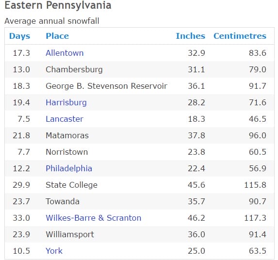
The question going forward of course is what about Winter 2016-2017? Well first off lets look at the normal numbers for a few specific spots. The first chart is for York Pennsylvania.

Now here is a list of other nearby areas and their annual snowfall. Notice that amounts skew higher as you go north into more elevated areas
Now that we understand the numbers what can we expect going forward? Well there are a few observations that I can make at the moment that would strongly suggest that we will at least revert back to a more normal snowfall profile as shown above. We base this on the following observations
- The overall long term trend for snowfall in Southeastern Pennsylvania is still in a 16 year uptrend
- The Super El Nino condition in the Pacific Ocean is no longer a factor as the El Nino has disappeared.
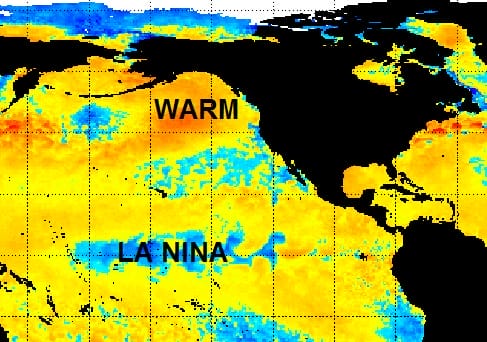
- The La Nina condition in the Pacific Ocean is at best weak and is no longer forecast to strengthen.
- Ocean water temperatures in the Northeast Pacific Ocean continue their multi year trend of being above normal by several degrees or more. This would favor a strong high in the Northwest which would open a pipeline for cold air in the Eastern US.

There are a few negatives going forward as well
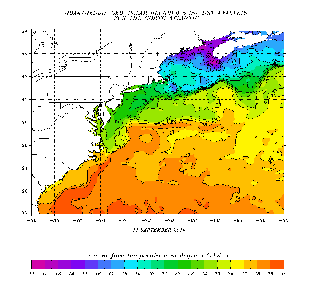
- Atlantic Ocean water temperatures remain above normal even though we did see cooling thanks to Tropical Storm Hermine. The warmer ocean could impact any early season snow events by sweeping in warmer air to the west. Water temperatures are still running several degrees above normal. Fall nor’easters or another tropical system moving up the east coast could correct this condition.

- The strong ridge in the east remains a huge factor. The persistent upper high that keeps rebuilding in the east would continue the pattern of warmer and drier than normal conditions into the start of the winter. This ridge in the east pattern needs to break down over the next several months.
Unknown variables include the following
The North Atlantic Oscillation or “Greenland Block” which is an unstable pattern that displaces cold air into the Eastern United States. This condition has been virtually absent for the last 4 winters. It is usually a pattern that sets up for a couple of weeks before reversing, though it has been known to last for months at a time.

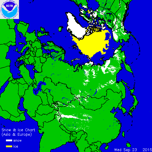
Also we watch the rate of snow cover growth in Siberia during the month of October. There is a connection (though far from perfect) that suggests that the rate of snow cover growth impacts winters in the Eastern US. The faster the rate, the colder and snowier it will be. This indicator did not work at all last year as it would have suggested a colder and snowier winter. The super El Nino trumped everything except during the time frame of the Blizzard of 2016. The map above is the snow cover as of 9/23 2016. As a comparison here is what it looked like on 09/23/2015
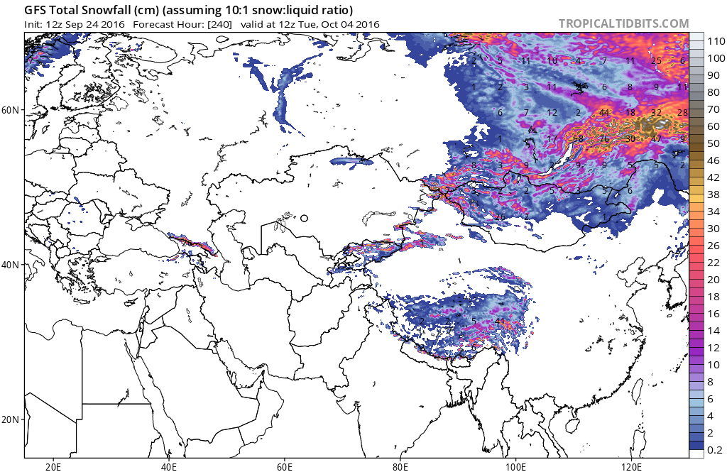
Little can be deduced from the comparison of the last 2 years as we are at the beginning of this process. During the next 2 weeks snowfall will begin to ramp up in northeastern regions of Asia as per the GFS model 2 week snowfall forecast.
As we take all this into account, I think at this point stating a more normal winter in terms of temperatures and snowfall would seem the no brainer forecast. As we move through the next 2 months we will continue to monitor all these indicators and zero in on a final forecast come early November.

MENTION JOE CIOFFI AND GET A 5% DISCOUNT
WINTER 2016-2017 PART 1 OCEAN WATER TEMPERATURES
WINTER 2016-2017 PART 2 ARCTIC SEA ICE AND SIBERIAN SNOW COVER
FiOS1 News Weather Forecast For Long Island
FiOS1 News Weather Forecast For New Jersey
FiOS1 News Weather Forecast For Hudson Valley
NATIONAL WEATHER SERVICE SNOW FORECASTS
LATEST JOESTRADAMUS ON THE LONG RANGE
Weather App

Don’t be without Meteorologist Joe Cioffi’s weather app. It is really a meteorologist app because you get my forecasts and my analysis and not some automated computer generated forecast based on the GFS model. This is why your app forecast changes every 6 hours. It is model driven with no human input at all. It gives you an icon, a temperature and no insight whatsoever.
It is a complete weather app to suit your forecast needs. All the weather information you need is right on your phone. Android or I-phone, use it to keep track of all the latest weather information and forecasts. This weather app is also free of advertising so you don’t have to worry about security issues with your device. An accurate forecast and no worries that your device is being compromised.
Use it in conjunction with my website and my facebook and twitter and you have complete weather coverage of all the latest weather and the long range outlook. The website has been redone and upgraded. Its easy to use and everything is archived so you can see how well Joe does or doesn’t do when it comes to forecasts and outlooks.
Just click on the google play button or the apple store button on the sidebar for my app which is on My Weather Concierge. Download the app for free. Subscribe to my forecasts on an ad free environment for just 99 cents a month.
Get my forecasts in the palm of your hand for less than the cost of a cup of Joe!
![]()

