Chilly Air Heading East Long Range

MENTION JOE CIOFFI AND GET A 5% DISCOUNT
Chilly Air Heading East Long Range
Temps 5 to 10 Degrees Below Normal
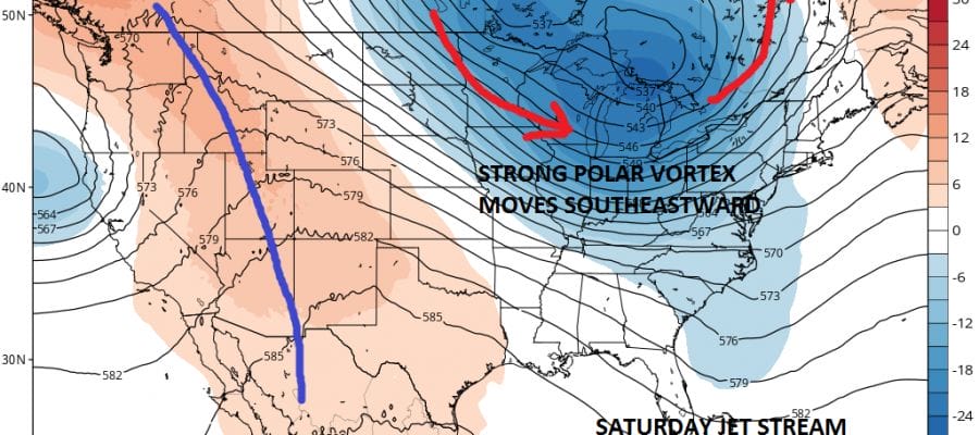
The overall pattern remains near or a little cooler than normal as we go into the weekend. Average highs this time of year are close to 70 or so plus or minus a few degrees. However the long range weather pattern is taking a decidedly chilly turn with a strengthening of the jet stream pattern out of Canada. This is going to bring down a shot of chilly air for Sunday and the first part of next week. An unusually strong polar vortex will be the driver here as it takes over the flow throughout Southern Canada and much of the northern half of the United States.
Chilly Air Heading East
GFS JET STREAM SATURDAY

Funny that we didn’t see something like this over the winter! When we did it only lasted a day or two. A flow like this will being tempertures down to as much as 10 degrees below normal. This time of year that would mean highs in the lower 60s and lows in the lower 40s or even 30s in cold spots. This cold air will arrive on Sunday. There will be a cold front coming through here Friday and then a second front late Saturday and both will have some showers when they pass.
Chilly Air Heading East
GFS MODEL TEMPERATURE DEPARTURE FROM NORMAL NEXT MONDAY
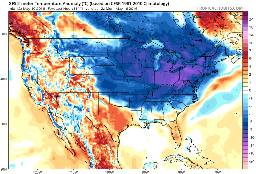
Saturday will be near 70 before the second front passes and then Sunday and Monday will be the two coldest days with highs just in the lower 60s. Temperatures may start to rebound a little by Tuesday of next week.
Chilly Air Heading East
GFS MODEL JET STREAM SUNDAY

Beyond early next week the pattern continues to look cooler than normal through the 10 day periods with weather fronts passing through every few days. There is no sign of any very warm air coming anytime soon unless there is an odd day here and there.
FiOS1 News Weather Forecast For Long Island
FiOS1 News Weather Forecast For New Jersey
FiOS1 News Weather Forecast For Hudson Valley
NATIONAL WEATHER SERVICE SNOW FORECASTS
LATEST JOESTRADAMUS ON THE LONG RANGE

NOMINATED FOR AN APPY AWARD FOR BEST WEATHER APP!!
Weather App

Don’t be without Meteorologist Joe Cioffi’s weather app. It is really a meteorologist app because you get my forecasts and my analysis and not some automated computer generated forecast based on the GFS model. This is why your app forecast changes every 6 hours. It is model driven with no human input at all. It gives you an icon, a temperature and no insight whatsoever.
It is a complete weather app to suit your forecast needs. All the weather information you need is right on your phone. Android or I-phone, use it to keep track of all the latest weather information and forecasts. This weather app is also free of advertising so you don’t have to worry about security issues with your device. An accurate forecast and no worries that your device is being compromised.
Use it in conjunction with my website and my facebook and twitter and you have complete weather coverage of all the latest weather and the long range outlook. The website has been redone and upgraded. Its easy to use and everything is archived so you can see how well Joe does or doesn’t do when it comes to forecasts and outlooks.
Just click on the google play button or the apple store button on the sidebar for my app which is on My Weather Concierge. Download the app for free. Subscribe to my forecasts on an ad free environment for just 99 cents a month.
Get my forecasts in the palm of your hand for less than the cost of a cup of Joe!
![]()

