
Brutal Heat Humidity Sunday
Brutal Heat Humidity Sunday
Highs 95-100 Heat Indices 105-110
Seeing some heat indices on Saturday hit above 110 was jaw dropping. The humidity levels were so high. It was as if the Northeast and Middle Atlantic States are now the new Gulf Coast. It reminded me of a hot day in mid summer in New Orleans when I lived there many years ago. Unofficially there was a report of a heat index hitting 113 over parts of Long Island. Sunday will be no different with highs climbing to between 95-100 and the dew points again in the middle 70s through most of the day.
Brutal Heat Humidity Sunday Forecast Highs

Brutal Heat Humidity Sunday Evening Dew Points

Now we do have a weather front that is forecast to move through Sunday night and there could be some thunderstorms developing ahead of it. The Storm Prediction Center of the National Weather Service is indicating a marginal risk of severe weather for Sunday in their preliminary forecast.
Brutal Heat Humidity Sunday Severe Weather Threat
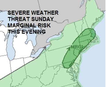
Below is the current satellite loop and you can see the front lining up to the west. Now models have been awful with regards to the development of thunderstorms both in terms of extent and strength. Suffice to say that given temperatures in the upper 90s and dew points in the 70s, you have a ripe atmosphere for some severe thunderstorms to develop. Again I would expect some areas to see them and some areas won’t


Monday & Tuesday Outlook
We should see some slight improvement as the extreme heat will be reduced. We should still see highs reaching the lower 90s in most places Monday afternoon. Humidity levels should be lower. Tuesday we could see the return of higher humidity and the chance for late afternoon thunderstorms. The warm tropical air won’t be that far away and another warm front will be setting up to our north. We could see the chance for showers and thunderstorms continue Tuesday night and Wednesday with very warm humid conditions.
FiOS1 News Weather Forecast For Long Island
FiOS1 News Weather Forecast For New Jersey
FiOS1 News Weather Forecast For Hudson Valley
NATIONAL WEATHER SERVICE SNOW FORECASTS
LATEST JOESTRADAMUS ON THE LONG RANGE
Weather App

Don’t be without Meteorologist Joe Cioffi’s weather app. It is really a meteorologist app because you get my forecasts and my analysis and not some automated computer generated forecast based on the GFS model. This is why your app forecast changes every 6 hours. It is model driven with no human input at all. It gives you an icon, a temperature and no insight whatsoever.
It is a complete weather app to suit your forecast needs. All the weather information you need is right on your phone. Android or I-phone, use it to keep track of all the latest weather information and forecasts. This weather app is also free of advertising so you don’t have to worry about security issues with your device. An accurate forecast and no worries that your device is being compromised.
Use it in conjunction with my website and my facebook and twitter and you have complete weather coverage of all the latest weather and the long range outlook. The website has been redone and upgraded. Its easy to use and everything is archived so you can see how well Joe does or doesn’t do when it comes to forecasts and outlooks.
Just click on the google play button or the apple store button on the sidebar for my app which is on My Weather Concierge. Download the app for free. Subscribe to my forecasts on an ad free environment for just 99 cents a month.
Get my forecasts in the palm of your hand for less than the cost of a cup of Joe!

MENTION JOE CIOFFI AND GET A 5% DISCOUNT


