Beware The Southeast Wind Today 70 Degree Highs Thursday Friday
Colder Weekend

Weather in 5/Joe & Joe Weather Show Latest Podcast
Beware The Southeast Wind Today 70 Degree Highs Thursday Friday
Colder Weekend
Today is going to be a bit if a different day. Yes we will have sunshine but we will have a south southeast wind all day long. This is going to put a lid on temperatures in a big way. We saw highs in the 60s on Tuesday but look for temperatures that will be about 10 degrees lower today in many locations.
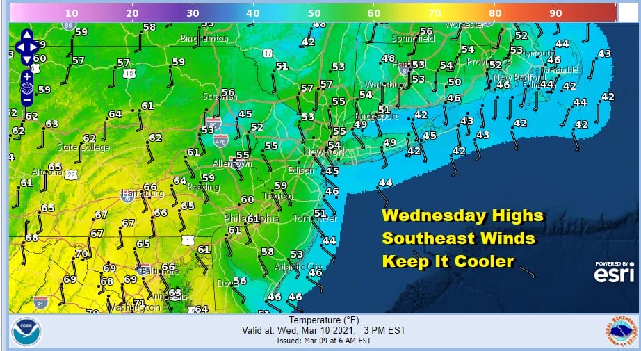
This is all thanks to a high that will be to our northeast and that is going to mean air coming off a 40 to 45 degree ocean. Highs along the immediate coast will likely not get out of the 40s. Inland highs will be in the 50s. Well inland is where you might see highs in the 60s but you will head to head to Southern Pennsylvania and points south into Maryland to see that.
SATELLITE

Usually the southeast wind is one that is loaded with moisture but not this time. Skies are mostly clear on the satellite and we should have plenty of sunshine today. The radars are nice and quiet and they will remain this way into Thursday night.
F5 WEATHER RADARS


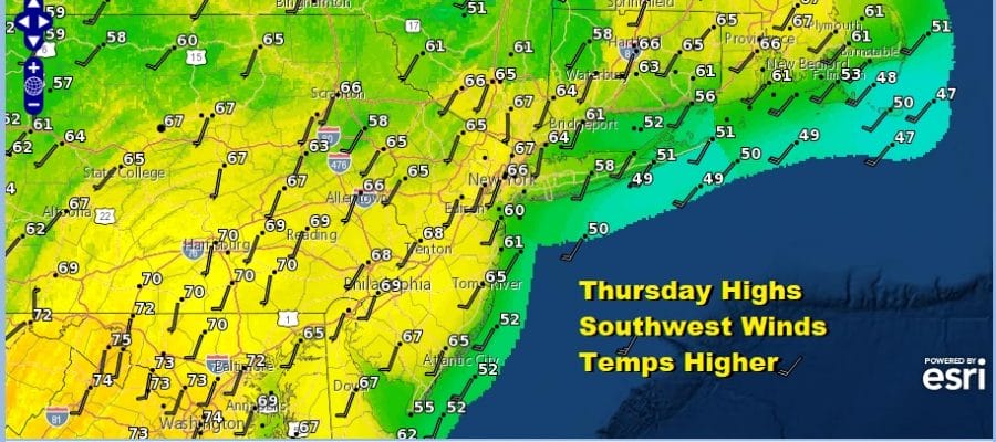
Tonight will be relatively mild with some patchy fog developing in some areas. Overnight lows will be in the upper 30s to mid 40s. The launching pad will be set for Thursday. The high changes position to just off the Mid Atlantic coast and that turns the wind Thursday to southwest. A solid launching pad, a better wind direction, and lots of sunshine means highs could reach the 70s just away from coastal areas.

Friday will bring a cold front through early with nothing more than a passing shower. Then with a west wind and developing sunshine, highs should be in the 60s to near 70 before colder air starts to come in Friday night.

Chilly air returns for the weekend. We should see some sunshine both Saturday and Sunday with highs back in the 40s along with an annoying gusty wind. The next storm system coming out of the west moves east and weakens. There is some question on timing. The GFS model seems a little fast and it shows a weakening area of precipitation coming into some colder air. This is way it shows a little snow and freezing precip in the mix on the loop above. The pattern overall remains drier than normal so we may have to wait until later next week for any kind of meaningful precipitation.
BE SURE TO DOWNLOAD THE FREE METEOROLOGIST JOE CIOFFI WEATHER APP &
ANGRY BEN’S FREE WEATHER APP “THE ANGRY WEATHERMAN!

MANY THANKS TO TROPICAL TIDBITS & F5 WEATHER FOR THE USE OF MAPS
Please note that with regards to any severe weather, tropical storms, or hurricanes, should a storm be threatening, please consult your local National Weather Service office or your local government officials about what action you should be taking to protect life and property.


