
Back to Gloom & Doom Next 3 Days
Heavy Rain Strong Winds Late Thursday Into Friday

Back to Gloom & Doom Next 3 Days
Heavy Rain Strong Winds Late Thursday Into Friday
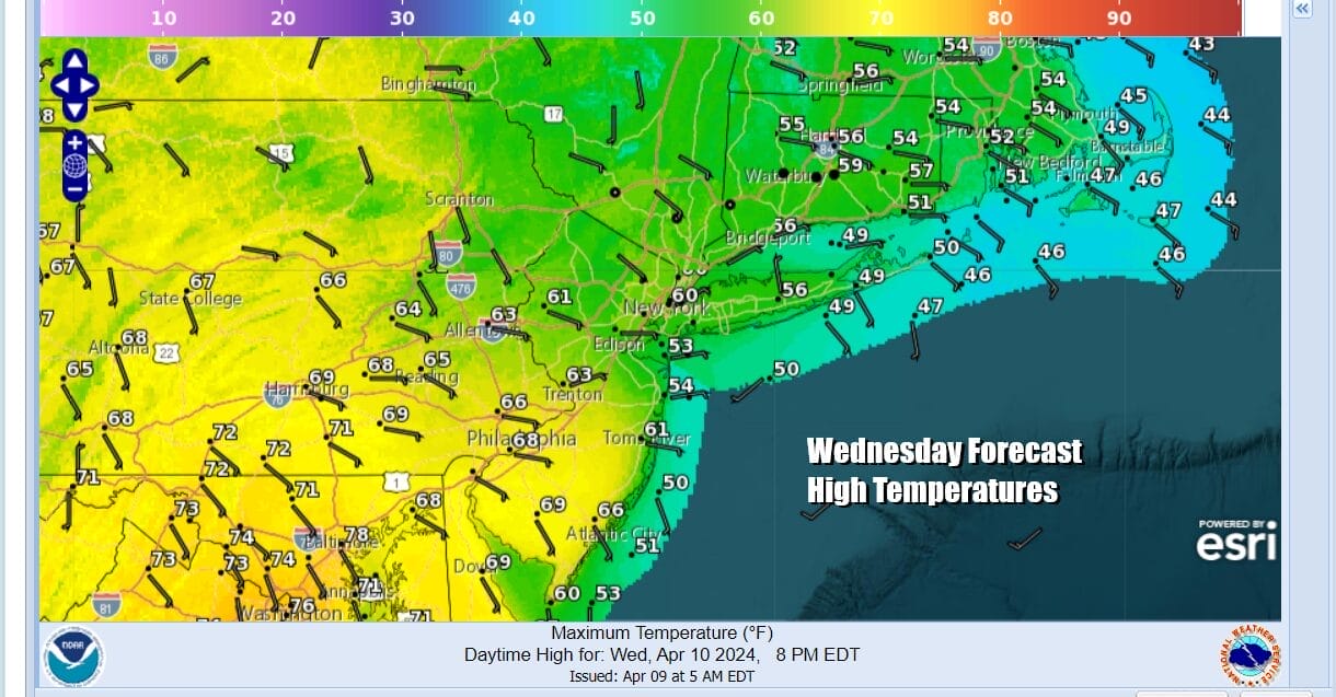
During the spring you usually get 1 or maybe 2 days of nice weather so we have appeared to reach our limit. After a day of highs in the 70s to near 80 degrees and a good deal of sunshine, it is now time for us to descend into the land of gloom & doom. However location will matter as a warm front begins to set up across Pennsylvania and New Jersey. Depending on which side of the front you are will determine how much cloud cover and whether you might have a shower or two of rain. From NYC eastward highs today will be in the 50s to near 60 with lots of clouds and the risk for some passing showers. South and southwest of Philadelphia (including South Jersey) will see clouds but some breaks of sunshine possible. Highs in these areas will be in the upper 60s and lower 70s. If you are in between the two areas it could go either way. Radars are picking up on some showers but it is not widespread coverage.
SATELLITE WITH LIGHTNING STRIKES

WEATHER RADAR

Low pressure is developing in East Texas today and this storm system is going to create a lot of severe weather today and tonight. Widespread severe thunderstorms are forecast across parts of the central Gulf Coast States. The potential will exist for several tornadoes, a few of which may be strong (EF2+), and widespread damaging winds, some of which may exceed 75 mph. Heavy rain is also an issue with a moderate risk for flash flooding. The area shifts to the East Coast later Thursday into Friday.

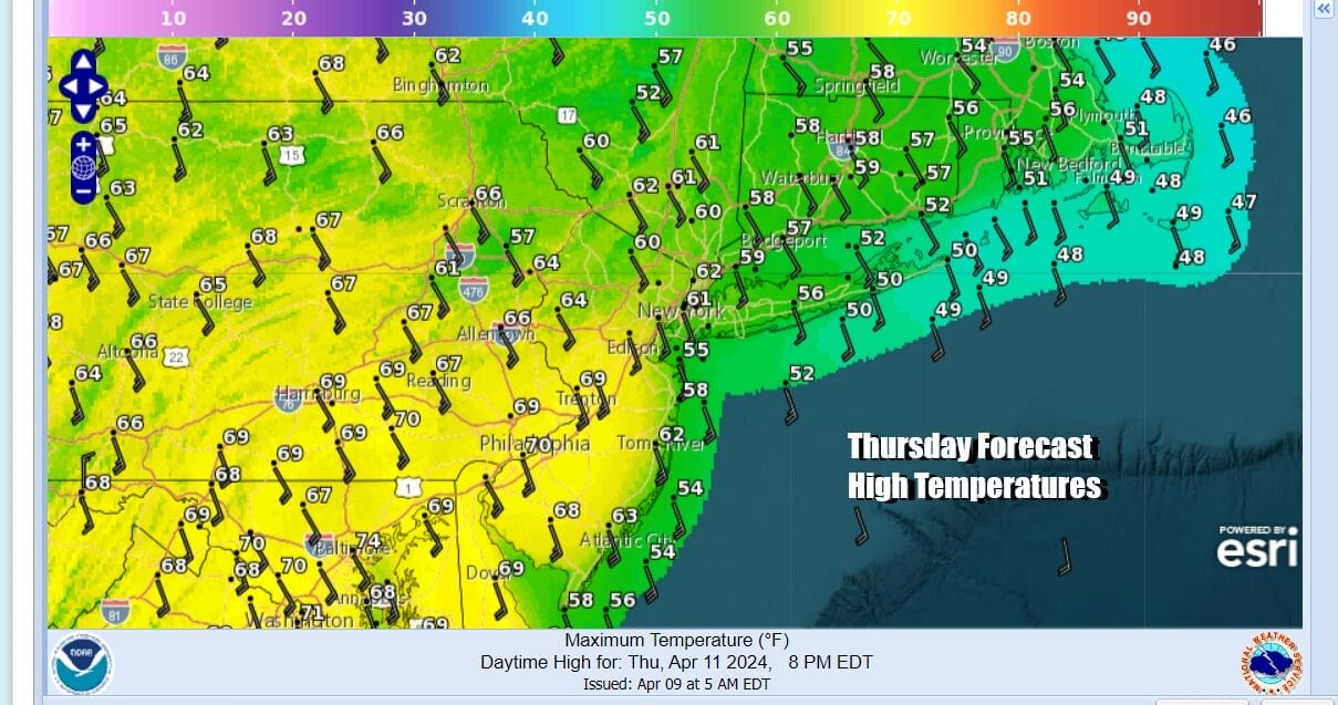
Tonight and Thursday across Eastern Pennsylvania to Southern New England we will see lots of clouds and some scattered showers. As the day wears on we will start to see southerly winds pick up especially along the coast and rain will develop during the late afternoon and evening from west to east. Thursday highs will be mostly in the 60s except along the immediate coast.
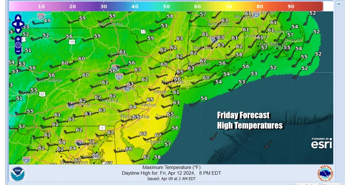
Thursday night into Friday morning we will see strong south winds with gusts over 40 mph possible especially along the coast. Rain will be heavy at times and there is the risk for a thunderstorm or two. Rainfall amounts at the moment are forecast to be in the range of 3/4 inch to 1.50 inches with higher amounts inland. This puts us close to the threshold of a flood watch so we will see what the National Weather Service does with this later today. Winds will shift from south to west during the day Friday as the rain ends but there will still be leftover clouds and showers with highs in the 60s.
Over the weekend it looks like Saturday might be a better day than Sunday as winds diminish and we have some sunshine and highs in the upper 50s and lower 60s. Sunday sees a cold front dropping southeast from the Great Lakes and that could bring clouds and the risk for showers later in the day and into Sunday night. Next week we get a break from this endless run of major storm systems as the overall pattern seems calmer though not necessarily rain free.
BE SURE TO DOWNLOAD THE FREE METEOROLOGIST JOE CIOFFI WEATHER APP &
ANGRY BEN’S FREE WEATHER APP “THE ANGRY WEATHERMAN!
MANY THANKS TO TROPICAL TIDBITS FOR THE USE OF MAPS
Please note that with regards to any severe weather, tropical storms, or hurricanes, should a storm be threatening, please consult your local National Weather Service office or your local government officials about what action you should be taking to protect life and property.
(Amazon is an affilate of Meteorologist Joe Cioffi & earns commissions on sales.)


