August Heat Humidity
[brid video=”58182″ player=”6390″ title=”tuesday”]
August Heat Humidity
We begin this Tuesday with dry air and plenty of sunshine and the satellite loop shows the dry air mass over the northeast has enough left in it to carry us through one more day. To the south in the Southeast, off Florida and in the Northeast Gulf of Mexico is a disturbance in the mid and upper layers of the atmosphere. With a ridge of high pressure aloft building along and just off the Middle Atlantic Coast, the door opens for humidity to return as well as some hot temperatures. Wednesday will be a day of transition as a warm front moves through. This will produce some downpours and scattered thunderstorms. Temperatures today will be in the mid to upper 80s. Wednesday’s highs will be in the low to mid 80s with more clouds.


August Heat Humidity
Thursday Through Saturday
Look for very warm steamy conditions to take over through Saturday. This means we will see clouds and sun during the day and there is the risk for scattered downpours or thunderstorms each afternoon and evening. Daytime highs Thursday through Saturday will be in the upper 80s to lower 90s. NIghttime lows will be in the steamy 70s. The next weather front of consequence will be here Saturday night or Sunday and it may take a while for it to work through. We will see if that results in any important rainfall.

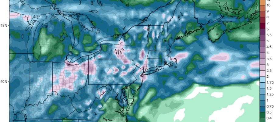
Rainfall through Sunday is forecast to be substantial in some places but it will be isolated with wide variations from place to place and day to day. Some areas that could use a widespread heavy rainfall may still wind up not getting it.
FiOS1 News Weather Forecast For Long Island
FiOS1 News Weather Forecast For New Jersey
FiOS1 News Weather Forecast For Hudson Valley
NATIONAL WEATHER SERVICE SNOW FORECASTS
LATEST JOESTRADAMUS ON THE LONG RANGE
Weather App

Don’t be without Meteorologist Joe Cioffi’s weather app. It is really a meteorologist app because you get my forecasts and my analysis and not some automated computer generated forecast based on the GFS model. This is why your app forecast changes every 6 hours. It is model driven with no human input at all. It gives you an icon, a temperature and no insight whatsoever.
It is a complete weather app to suit your forecast needs. All the weather information you need is right on your phone. Android or I-phone, use it to keep track of all the latest weather information and forecasts. This weather app is also free of advertising so you don’t have to worry about security issues with your device. An accurate forecast and no worries that your device is being compromised.
Use it in conjunction with my website and my facebook and twitter and you have complete weather coverage of all the latest weather and the long range outlook. The website has been redone and upgraded. Its easy to use and everything is archived so you can see how well Joe does or doesn’t do when it comes to forecasts and outlooks.
Just click on the google play button or the apple store button on the sidebar for my app which is on My Weather Concierge. Download the app for free. Subscribe to my forecasts on an ad free environment for just 99 cents a month.
Get my forecasts in the palm of your hand for less than the cost of a cup of Joe!

MENTION JOE CIOFFI AND GET A 5% DISCOUNT


