
Arriving Clouds & More Rain Through Friday Night
The Weekend & Mother’s Day Dry & Seasonal
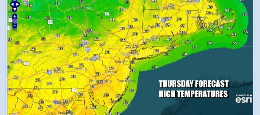
We are starting the day with not much cloud cover but we have a weakening cold front to the northwest and lower pressures across much of the Southeast US. Couple this with a strong upper trough that is dropping southeastward from Canada and you have the ingredients for a soaking heavy rain developing tonight and lasting into early Saturday morning. Back to today look for increasing clouds with most highs in the upper 60s and lower 70s.
SATELLITE WITH LIGHTNING STRIKES

WEATHER RADAR

Some showers will develop inland late this afternoon and this evening. As low pressure develops in the Carolinas tonight and Friday, and expanding area of rain will develop from Virginia to Southern New England. There will be some thunderstorms in the mix as well as the low moves northeastward up the coast Friday into Friday night.

The good news is that there is no blocking so the low will move along and that should lead to improving weather conditions Saturday. Also we have another upper trough across the Deep South and this system will remained pinned to our south at least into the early part of next week. The rainfall late Thursday into early Saturday will be substantial.
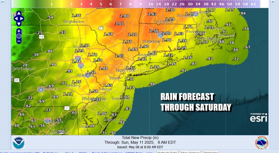
Forecasts for 1.5 to 2.5 inches of rain are in place for Eastern Pennsylvania to Southern New England. There is risk for some localized flash flooding especially for areas in Northeast Pennsylvania, Northwest New Jersey and parts of the Hudson Valley. While it rains Friday there will be a raw onshore wind and most temperatures will be in the upper 50s and lower 60s.

Most of the rain should be done by daybreak except perhaps for Eastern Connecticut and Eastern Long Island but most of Saturday will be spent in leftover clouds. There should be some sunshine developing though from west to east Saturday afternoon. Temperatures Saturday will be in the upper 60s and lower 70s. Sunday which is Mothers Day will be partly to mostly sunny and a perfect May day with highs in the low to middle 70s.
BE SURE TO DOWNLOAD THE FREE METEOROLOGIST JOE CIOFFI WEATHER APP &
ANGRY BEN’S FREE WEATHER APP “THE ANGRY WEATHERMAN!
MANY THANKS TO TROPICAL TIDBITS FOR THE USE OF MAPS
Please note that with regards to any severe weather, tropical storms, or hurricanes, should a storm be threatening, please consult your local National Weather Service office or your local government officials about what action you should be taking to protect life and property.


