Another Winner of a Day Sunshine Temperatures Reaching 70 or Better

Weather in 5/Joe & Joe Weather Show Latest Podcast
Another Winner of a Day Sunshine Temperatures Reaching 70 or Better
Overnight an upper air disturbance passed by with little fanfare other than a few clouds and now we are left in pretty much the same place we were yesterday. To the northeast we have a storm south of Nova Scotia which is going no where fast. Clouds from this storm are as far west as coastal Eastern New England. To the northwest we have another upper air disturbance that is moving southeast and will weaken as it does so. In between we sit with another good looking day of weather.

Temperatures should reach into the 70s in many locations today and even along coastal areas the sea breeze will be minimal if you get a sea breeze at all. It will also be another dry day of very low humidity in the 20-30% range or less in some places so once again there is brush fire risk. It will be breezy at times but the wind should be a little less than yesterday,.
SATELLITE

This is what happens when you are in the sweet spot of a blocking pattern. That should hold for another day or two before the traffic jam breaks down enough to allow weather systems to our west to move east. Tonight the upper air disturbance from the Great Lakes will pass by with clouds and maybe a scattered shower in parts of Central and Southeastern Pennsylvania to Delaware and Southern New Jersey but there is a fair chance any showers will fall apart. Otherwise Wednesday will be partly to mostly sunny (just some leftover clouds in the morning hours for some). Highs again will be in the upper 60s and lower 70s in most places.
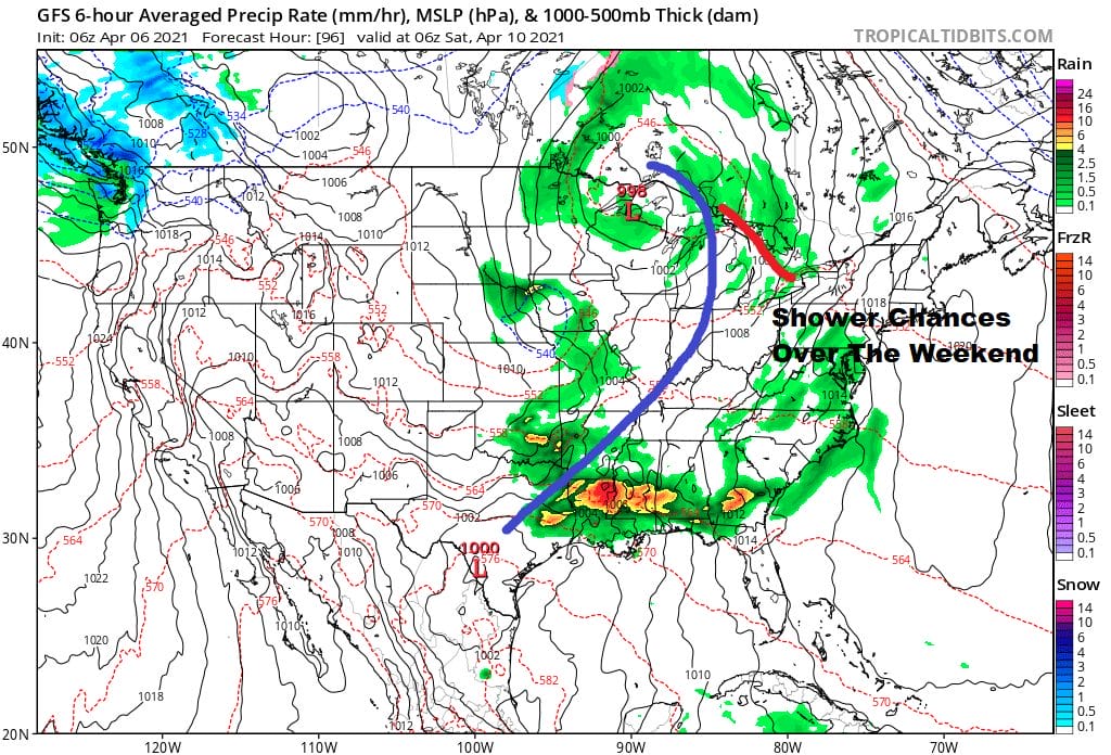
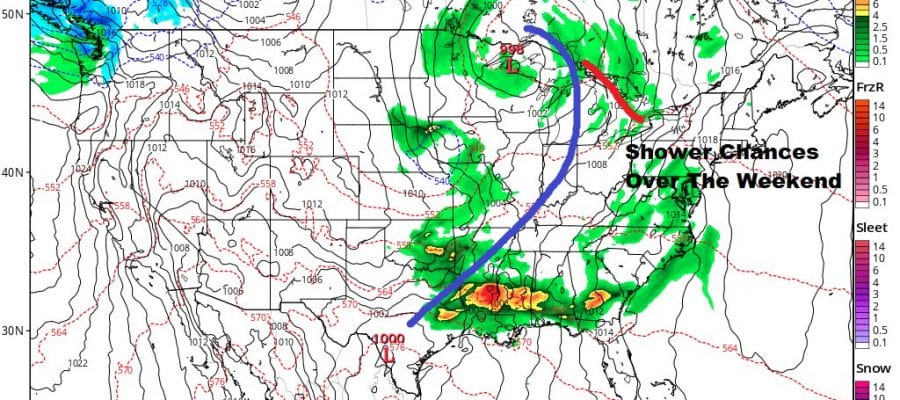
The block begins to weaken and shift eastward on Thursday which allows the wind to go more onshore and high pressure builds south from Eastern Canada. It isn’t a strong high so we should see highs reach the 60s Thursday with a mix of sun and clouds. Low pressure starts to try and push east from the Great Lakes but the Nova Scotia storm will remain offshore. Though further out to the east, it still doesn’t leave much room for anything major to occur. We could see a few scattered showers on Friday and probably more clouds. The risk for showers will carry us through the weekend though it will not be a washout by any means. Clouds will limit temperatures and keep them in the 50s Friday and Saturday and perhaps upper 50s and lower 60s on Sunday.
BE SURE TO DOWNLOAD THE FREE METEOROLOGIST JOE CIOFFI WEATHER APP &
ANGRY BEN’S FREE WEATHER APP “THE ANGRY WEATHERMAN!
MANY THANKS TO TROPICAL TIDBITS FOR THE USE OF MAPS
Please note that with regards to any severe weather, tropical storms, or hurricanes, should a storm be threatening, please consult your local National Weather Service office or your local government officials about what action you should be taking to protect life and property.


