Another Front Another Shot of Chilly Air No Rain Through Late Next Week

Another Front Another Shot of Chilly Air No Rain Through Late Next Week

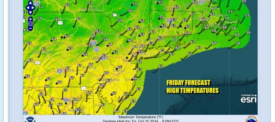
We have arrived at the doorstep of the weekend under a clear sky and another day of sunshine and no rain. This is the 26th consecutive day of no measurable rain for the vast majority of residents of Eastern Pennsylvania to Southern New England. Today is a sunny day and coming off a chilly overnight, temperatures will rebound this afternoon into the low and middle 60s. Nothing is on the radar. Not much is on the satellite as far as clouds are concerned. We do see clouds from the next cold front moving through the Great Lakes. This will be another weather front where any showers with the front will completely fall apart before they arrive here.
SATELLITE WITH LIGHTNING STRIKES

WEATHER RADAR

The weather front will pass through tonight into Saturday morning with nothing more than clouds. Lows will be in the 40s inland and low to mid 50s coast and warmer urban areas. Saturday we will see decreasing clouds and increasing sunshine along with a gusty breeze developing and temperatures in the mid 60s to around 70 degrees.

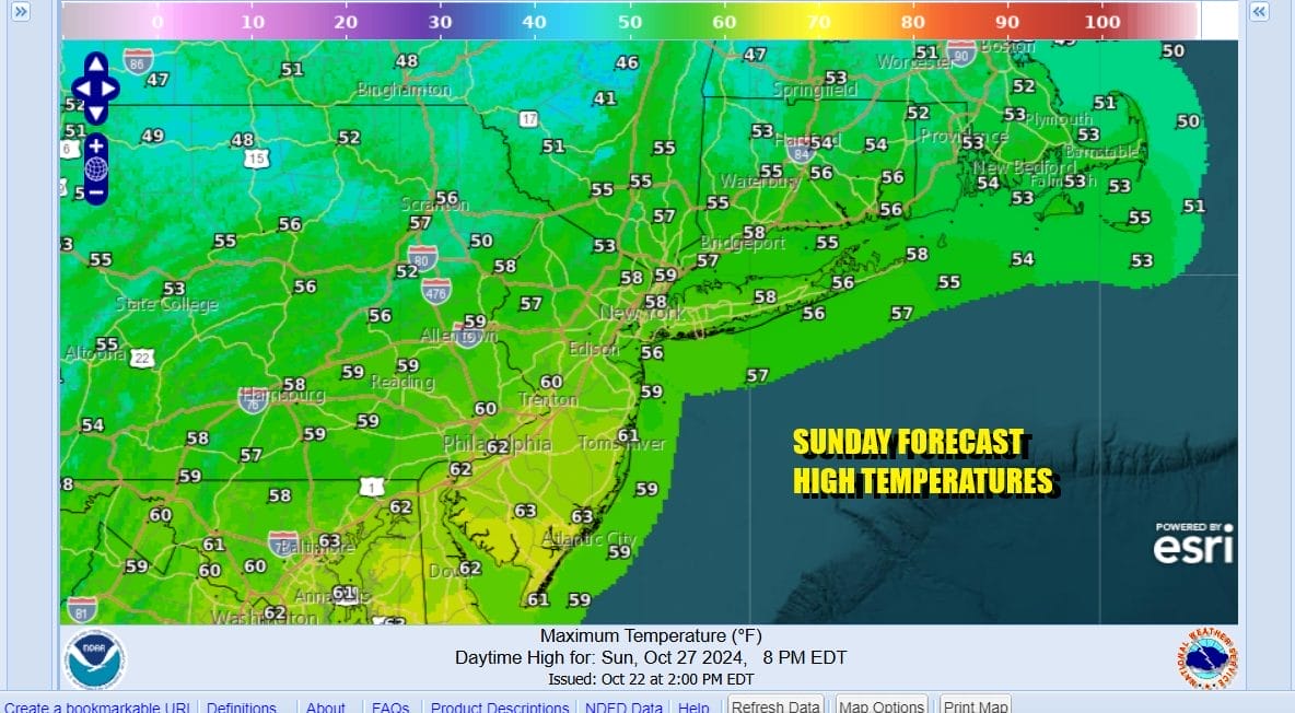
The next shot of colder air comes in Saturday night and we will be down in the 30s inland and low to mid 40s coast by Sunday morning. Sunday will be a mostly sunny day but it will be a chilly day. Most highs will be just in the 50s. Sunday night night into Monday morning will be quite chilly with low 40s in warmer urban areas, lots of 30s inland and even a few 20s in cold spots.
Next week will start out chilly but the cold high moves out and we begin the next bounce higher in steps. Monday will be sunny and chilly with highs in the mid 50s to around 60 or so. Then after a chilly night, we see temperatures begin to rise Tuesday through Friday. Tuesday we will be in the mid to upper 60s. By Wednesday we will be in the 70s. By Thursday we will be in the 70s to around 80 for Halloween. There is no rain in the forecast all week. Friday we will see another cold front approach but this front will, as the others, probably be just some clouds moving through. If this verifies we will see many cities setting records, not only for the driest October ever but in many cases the driest month ever. For some places it will also be the first time with no measurable rainfall for an entire calendar month!
BE SURE TO DOWNLOAD THE FREE METEOROLOGIST JOE CIOFFI WEATHER APP &
ANGRY BEN’S FREE WEATHER APP “THE ANGRY WEATHERMAN!
MANY THANKS TO TROPICAL TIDBITS FOR THE USE OF MAPS
Please note that with regards to any severe weather, tropical storms, or hurricanes, should a storm be threatening, please consult your local National Weather Service office or your local government officials about what action you should be taking to protect life and property.


