Another Day of Sunshine Warm Up Begins No Rain Through Sunday
WEATHER IN 5 PODCAST 9/23/2020
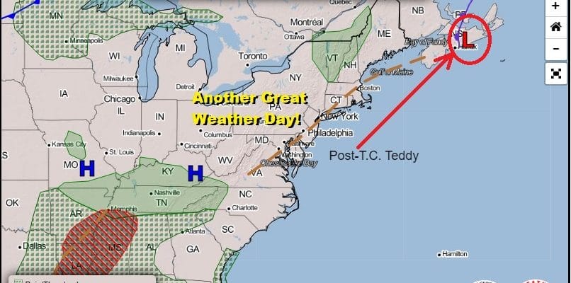
Our great weather continues today after a night of northwest winds behind Post Tropical Cyclone Teddy. Teddy is on the upper right hand corner of the satellite picture and is moving through Nova Scotia, heading for Newfoundland late today and tonight. It is a large cyclone in terms of circulation and lots of dry air has been drawn southward. This basically re-enforces our dry air for another few days. It also means with the high now to our south, we are going to warm up. Highs today will reach the 70s to near 80. It should be mostly sunny all day long and nothing shows up on the radar,
SATELLITE

REGIONAL RADAR

Tonight should be mainly clear sky wise and it won’t be as cool as past nights. Most lows will settle in the 50s though there will be 40s in cooler spots inland. Thursday will be a repeat of today with mainly sunny skies. Some high clouds from the remnants of Tropical Storm Beta will reach up into the Mid Atlantic states on Thursday but the rains should never reach this far north. Highs will be in the 70s to near 80. High pressure remains offshore Friday through Sunday. We will start to get into scenarios where low clouds could develop during the nighttime and early morning hours and then burn off to some sunshine. Highs will be in the 70s to near 80 each day with no rain forecast for the weekend.

Next week the pattern changes to a more active one with weather systems moving back into play and no tropical storms bookending the upper and keeping systems in place. The first of two cold fronts arrives with widespread showers for Monday. The great weather we have been having has now created very dry conditions in parts of Eastern Pennsylvania to Southern New England so the showers should bring some relief. A second front will arrive on Wednesday with the chance for more showers.

Behind the second front will be much cooler air coming in as a large high drops southward from Central Canada. Temperatures will trend below normal after that second front comes through. We might also see the front stall out and create a set up for another wave of low pressure late next week and rain. In the meantime, no major storms, no issues, just sunshine most of the time now through Sunday.
BE SURE TO DOWNLOAD THE FREE METEOROLOGIST JOE CIOFFI WEATHER APP &
ANGRY BEN’S FREE WEATHER APP “THE ANGRY WEATHERMAN!
MANY THANKS TO TROPICAL TIDBITS FOR THE USE OF MAPS
Please note that with regards to any severe weather, tropical storms, or hurricanes, should a storm be threatening, please consult your local National Weather Service office or your local government officials about what action you should be taking to protect life and property.


