A Sunday of Sunshine But Showers Overnight into Early Monday
Week Ahead Outlook

A Sunday of Sunshine But Showers Overnight into Early Monday
Week Ahead Outlook

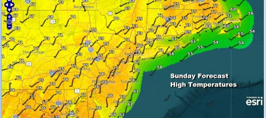
We are going to enjoy a mostly nice Sunday. The satellite loop this morning does show clouds and what is the leading edge of some showers to the west but they aren’t in a rush to get here and we should see a good deal of sunshine this morning and then some clouds will start to move in from west during this afternoon. There is enough sunshine to boost temperatures nicely today and highs should reach the middle to some upper 70s except for right along the immediate coast where sea breezes will hold temperatures back somewhat. Overall though the dayside today looks fine.
SATELLITE

WEATHER RADAR

Tonight’s weather system is the first of two disturbances that will be moving through. Both of these systems look to be on the weak side and won’t produce much in the way of rain. We are thinking maybe a tenth of an inch to maybe 2 tenths tops. The second disturbance comes through later Tuesday into Tuesday night in the form of a cold front moving southeastward.

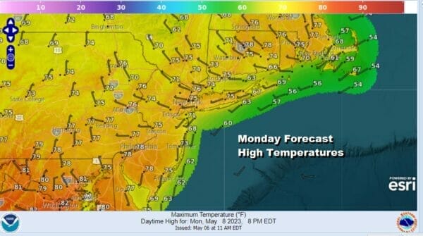
Once tonight’s showers are done we should see improving weather conditions by Monday daybreak and skies should be partly to mostly sunny Monday. The air behind tonight’s weather system is no different from the air ahead of it so high temperatures Monday will again be in the mid to upper 70s.
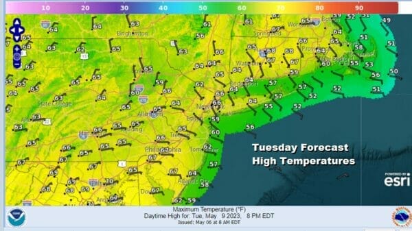
Tuesday will be a different sort of day with clouds moving in and we will have more of a southeast wind off the ocean. That will make for temperatures Tuesday 10 degrees lower than Monday. Also look for some showers to move in the mid to late afternoon and then pass offshore Tuesday night. High temperatures Tuesday will be in the cooler 60s.
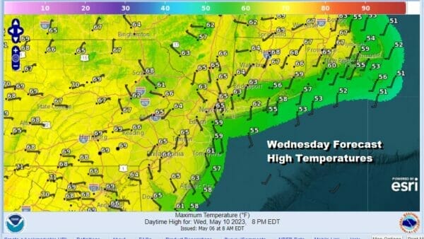
Wednesday and Thursday will be nice days with sunshine as high pressure builds in from the Midwest. Wednesday highs will be in the 60s. Thursday we should warm up somewhat ahead of another cold front. Sunshine should take highs Thursday well into the mid and upper 70s.
Before that front passes late Friday, we will see very warm temperatures reaching into the 80s. Right now we can be optimistic for next Saturday into at least the first part of Sunday but depending on timing we might be dealing with some showers late Mother’s Day though it is rather early to make definitive statements about next weekend.
BE SURE TO DOWNLOAD THE FREE METEOROLOGIST JOE CIOFFI WEATHER APP &
ANGRY BEN’S FREE WEATHER APP “THE ANGRY WEATHERMAN!
MANY THANKS TO TROPICAL TIDBITS & F5 WEATHER FOR THE USE OF MAPS
Please note that with regards to any severe weather, tropical storms, or hurricanes, should a storm be threatening, please consult your local National Weather Service office or your local government officials about what action you should be taking to protect life and property.


