
A Mixed Weekend of Clouds & Sun Warmer Springlike Weather Next Week
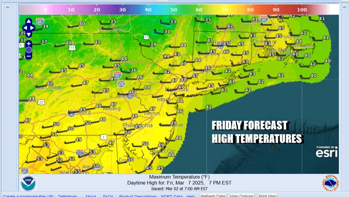
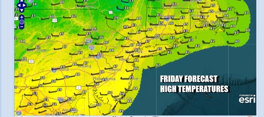
We have arrived at the doorstep of the weekend. Wind advisories continue today as the gradient remains very tight across the Northeast. West winds will gust to 40 mph or more at times. At least we will have a decent weather day with sunshine mixed with clouds. Temperatures this afternoon will reach the upper 40s and lower 50s. Winds will begin to ease late today and tonight as the gradient relaxes. Temperatures will cool off tonight but it won’t be especially cold. Lows Saturday morning will be in the low to middle 30s.
SATELLITE WITH LIGHTNING STRIKES

WEATHER RADAR

A snow storm in the Western US will be heading eastward but due to the presence of a storm system in Atlantic Canada, and a northwest flow aloft. That system will weaken rather rapidly today and it will completely fall apart. Other than some clouds and maybe a few scattered rain or snow showers overnight, there will be no important impact from this system.

Also we have a storm system moving across the Deep South and that system will head straight east and off the Southeast US coast over the weekend. It can’t move north because the Atlantic Canada storm is in the way. This leaves us with a decent weekend. Saturday will see clouds, some sun, and breezy conditions. Most highs will be in the 40s to around 50.

Sunday offers more of the same as we will see sunshine and just a few passing clouds at worst. High temperatures Sunday. Morning lows will be in the 20s to near 30 and afternoon highs will be in the upper 40s and lower 50s. Don’t forget that Daylight Saving Time begins Sunday so clouds go an hour ahead Saturday night.
Next week brings a big warm up for the first half of the week. Warm west-southwest winds on the backside of a high off the Southeast US coast will take temperatures into the 60s in many locations. We will have sunshine and we are at the time of year where sunshine can boost temperatures higher than advertised thanks to the strengthening sun angle. Tuesday we could see highs in the 60s to near 70 degrees for the first time since November.
BE SURE TO DOWNLOAD THE FREE METEOROLOGIST JOE CIOFFI WEATHER APP &
ANGRY BEN’S FREE WEATHER APP “THE ANGRY WEATHERMAN!
MANY THANKS TO TROPICAL TIDBITS FOR THE USE OF MAPS
Please note that with regards to any severe weather, tropical storms, or hurricanes, should a storm be threatening, please consult your local National Weather Service office or your local government officials about what action you should be taking to protect life and property.


