80 DEGREE TEMPERATURES IN SOUTHERN NEW JERSEY
80 DEGREE TEMPERATURES IN SOUTHERN NEW JERSEY
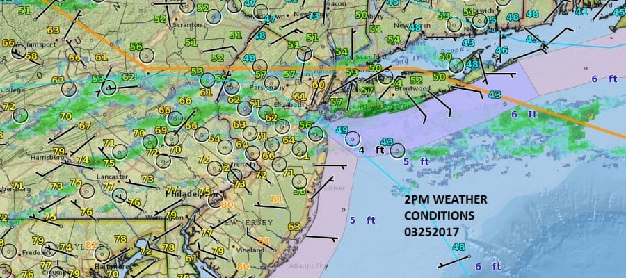
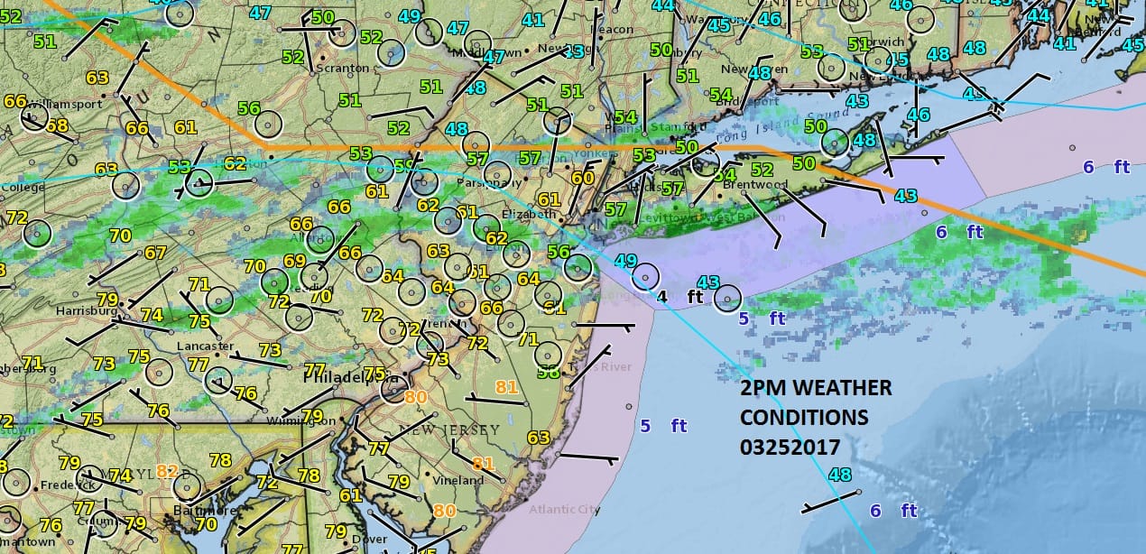
You have to love backdoor cold fronts this time of year. As of 2pm the front sits across Northern New Jersey where temperatures right now area in the upper 40s with a northeast wind and on their way down. Just a relatively short distance away in South Jersey south of Route 195 it is in the 70s and in the Southern Counties temperatures have reached the 80s! 200 miles or so gives you a spread of some 35 degrees! You can see the backdoor front on the surface map above as it cuts across New Jersey, New York City and Long Island. It is in the 40s in the areas to the north including the Hudson Valley and Connecticut.
SATELLITE LOOP

You can see how this is all connected to a storm in Western Missouri with the front snaking across the Great Lakes and out to another low developing offshore near Nova Scotia. Meanwhile northeast of the Bahamas we have a developing gale center there which would likely be a subtropical system if this were June and not late March. Some showers are strung out on the regional radar along the frontal boundary while to the north in Upstate NY and extending into Central New England we have some snow and rain with mostly snow on the New England side.
REGIONAL RADAR

LOCAL RADAR NEW YORK CITY

LOCAL RADAR PHILADELPHIA


Look for that front to continue to move south and you will know when it passes as the wind will go around to the northeast and you will also begin to sense the temperature dropping. Sunday’s highs will be a lot colder everywhere. Areas today that hit 80 will be in the 50s to perhaps 60 on Sunday while around Northern New Jersey to Southern New England it is likely to be damp and dreary with highs just in the upper 30s and lower 40s.
 GET JOE A CIGAR IF YOU LIKE

SNOW REMOVAL COMPANIES FOR YOUR WINTER NEEDS
LONG ISLAND ROCKLAND COUNTY Connecticut

![]()

ROCKLAND COUNTY TRI STATE SNOW REMOVAL JOHNSTOWN PA


FiOS1 News Weather Forecast For Long Island
FiOS1 News Weather Forecast For New Jersey
FiOS1 News Weather Forecast For Hudson Valley
NATIONAL WEATHER SERVICE SNOW FORECASTS
LATEST JOESTRADAMUS ON THE LONG RANGE
Weather App

Don’t be without Meteorologist Joe Cioffi’s weather app. It is really a meteorologist app because you get my forecasts and my analysis and not some automated computer generated forecast based on the GFS model. This is why your app forecast changes every 6 hours. It is model driven with no human input at all. It gives you an icon, a temperature and no insight whatsoever.
It is a complete weather app to suit your forecast needs. All the weather information you need is right on your phone. Android or I-phone, use it to keep track of all the latest weather information and forecasts. This weather app is also free of advertising so you don’t have to worry about security issues with your device. An accurate forecast and no worries that your device is being compromised.
Use it in conjunction with my website and my facebook and twitter and you have complete weather coverage of all the latest weather and the long range outlook. The website has been redone and upgraded. Its easy to use and everything is archived so you can see how well Joe does or doesn’t do when it comes to forecasts and outlooks.
Just click on the google play button or the apple store button on the sidebar for my app which is on My Weather Concierge. Download the app for free. Subscribe to my forecasts on an ad free environment for just 99 cents a month.
Get my forecasts in the palm of your hand for less than the cost of a cup of Joe!


