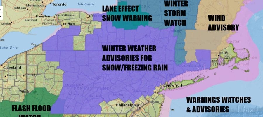
Winter Weather Advisory Snow & Ice Heavy Rain Sunday
Week Ahead Cold & Potentially Stormy

Winter Weather Advisory Snow & Ice Heavy Rain Sunday
Week Ahead Cold & Potentially Stormy
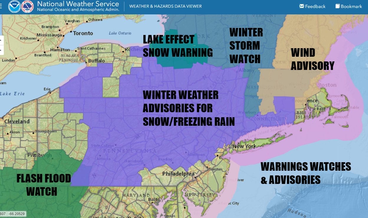
The next storm system will be playing out all weekend and we have Winter Weather Advisories up for areas just inland of the coast for later Saturday into Saturday night and, in some places north in the Hudson Valley and Northwest Connecticut, lasting into Sunday morning. Ahead of this is a windy and cold Friday as temperatures have bottomed in the 20s this morning. We will have a good deal of sunshine with high temperatures today mostly in the low to mid 30s.

Most of tonight skies should be clear. Some clouds however will arrive late at night or first thing Saturday morning with temperatures bottoming in the upper teens inland and low to mid 20s coast and warmer urban areas. Satellite and radar loops are picking up on some patchy cloudiness in Northeast and a little bit of lake effect is going on in parts of Upstate NY. This should diminish as the day wears on.
SATELLITE WITH LIGHTNING STRIKES

WEATHER RADAR

Saturday we watch low pressure heading out of the Tennessee and lower Ohio Valley. The low will head for the Appalachians and then head northeast, tracking into Western NY and eventually over New England Saturday night and Sunday. A warm front is setting up to the south and ahead of that we have snow that will break out from west to east Saturday afternoon into Saturday evening.
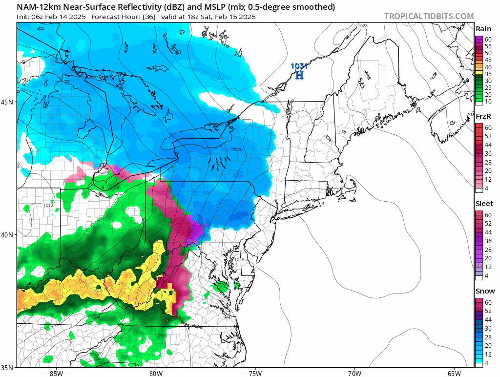
Cold air is wedged into the Northeast at least into Saturday evening. Gradually as the warm front pushes northward and warm air surges aloft, a change to sleet and freezing rain will occur and then, depending on temperature and location, ultimately to rain. This will happen rather fast on Long Island, Northern New Jersey and points to the south and southwest but it may take awhile for any change to rain to occur in the Hudson Valley as well as interior Southern New England. Most temperatures Saturday will reach their highs sometime in the evening hours to midnight, and low to middle 30s should do it for most places except South Jersey and points south which will be rising into the 40s.
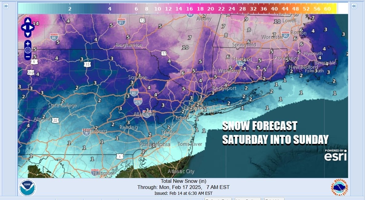
Snow amounts should be on the order of an inch or two coast with amounts rising as you head north and northeastward. Weather service forecast numbers could be a tad on the high side given the limited amount of time before a change over begins. We are talking about a 6 hour window for he any snow to fall. Inland areas where the climb above 32 will be much slower there is the potential for some ice accumulation.

Sunday as the low moves across Northern New England, a cold front will head east and this will likely set off an area of showers and perhaps even a thunderstorm or two. This will come through sometime late morning to mid afternoon. Temperatures Sunday from Central and South Jersey south will be in the mid to upper 50s while to the north we see temperatures lower but still in the 40s. You get far enough north in the Hudson Valley and Northern Connecticut and we are talking 30s.

Much colder air follows Sunday night and we will have a very cold week ahead. Monday through Wednesday will be dry however we have a set up in the upper atmosphere across North America that we don’t see too often. Higher than normal pressure across the Arctic region is going to force the polar vortex southward into the Western Great Lakes. Blocking in the Atlantic Ocean will force this low to dig southeast and there will be a resulting storm that will develop late this coming week along the East Coast.

Weather models have been circling around this idea for the better part of a week now and last night models all basically converged on this idea of a potential nor’easter later next week. There is still of course a high degree of uncertainty as well as the fact that we are talking 6 to 7 days out into the future. We will be monitoring the developments in the coming days very carefully.
BE SURE TO DOWNLOAD THE FREE METEOROLOGIST JOE CIOFFI WEATHER APP &
ANGRY BEN’S FREE WEATHER APP “THE ANGRY WEATHERMAN!
MANY THANKS TO TROPICAL TIDBITS FOR THE USE OF MAPS
Please note that with regards to any severe weather, tropical storms, or hurricanes, should a storm be threatening, please consult your local National Weather Service office or your local government officials about what action you should be taking to protect life and property.


