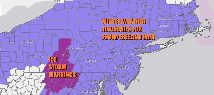
Winter Weather Advisory Snow Freezing Rain & Rain
Next Storm System Saturday Night into Sunday

Winter Weather Advisory Snow Freezing Rain & Rain
Next Storm System Saturday Night into Sunday

Our storm system is playing through Eastern Pennsylvania to Southern New England with freezing rain and some snow. Rain will eventually take over from south to north as we move through the morning hours. Snow will be on the northern flank and spread across the Hudson Valley and into New England. We saw no important changes overnight and as the HRRR model loop shows, this should be ending from west to east around midday. Snow amounts wiil finish up in the range of a coating to as much as an inch or 2 for most areas from Northern New Jersey to Southern New England before change to freezing rain or in some cases just plain rain.
SATELLITE WITH LIGHTNING STRIKES

WEATHER RADAR

Weather conditions are set to improve during this afternoon though there will be a lot of clouds around. Most highs will be in the 30s. Colder areas inland and northwest as well as northeast of the coast will probably have a harder time getting over the freezing mark. Temperatures tonight will likely be in the upper 20s inland and low to mid 30s elsewhere. A gusty wind will develop from the northwest which should keep refreezing to a minimum and perhaps allow for drying on paved surfaces.
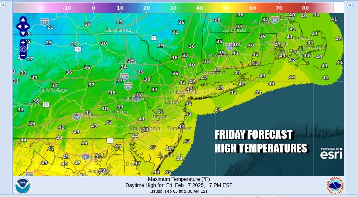
Friday will be a partly sunny windy and seasonal day with most highs in the upper 30s and lower 40s. Colder air will return Friday night and by Saturday morning most lows will be in the upper teens to mid 20s. Saturday we see the next storm system coming out of the Middle Mississippi Valley so look for any sunshine to give way to increasing clouds. Highs will be in the low to middle 30s.

This next storm system is the second in a series of 4 storms and while it is similar to today’s system in many ways there are a few subtle differences. One is that the low will be tracking further south and this will mean a slightly colder atmosphere. It will once again be a snow to freezing rain to rain situation Saturday night into Sunday morning. The low will move into West Virginia and then redevelop off the Delaware coast.

Once again we will see snow change to freezing rain across Pennsylvania. In New Jersey snow will fall along and north of Interstate 78 to NYC, Long Island, the Hudson Valley and Southern New England. A change to freezing rain or just rain is possible along southern and coastal areas but we could see at least a 2 to 4/3-5 inch snowfall from this.

This system will move out Sunday morning and we will see improving weather conditions Sunday afternoon with developing sunshine. Temperatures will be in the 30s. Monday into Tuesday looks to be dry and colder but then yet another storm (number 3) will develop in the Southeast US and take a northeast track off the Mid Atlantic coast. Snow is likely later Tuesday into early Wednesday. This system does have some potential to produce a solid accumulation from Eastern Pennsylvania to Southern New England including coastal areas of New Jersey and Long Island. There likely will be little risk of freezing rain from this system so at least ice will be off the table with this. We will speak more of this storm over the weekend especially once we are done with the Saturday night Sunday morning storm system.
BE SURE TO DOWNLOAD THE FREE METEOROLOGIST JOE CIOFFI WEATHER APP &
ANGRY BEN’S FREE WEATHER APP “THE ANGRY WEATHERMAN!
MANY THANKS TO TROPICAL TIDBITS FOR THE USE OF MAPS
Please note that with regards to any severe weather, tropical storms, or hurricanes, should a storm be threatening, please consult your local National Weather Service office or your local government officials about what action you should be taking to protect life and property.


