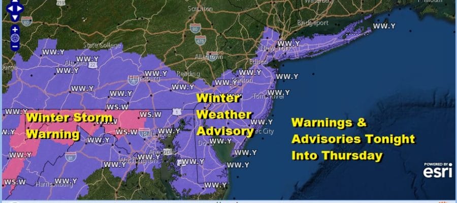
Winter Weather Advisory Overnight Into Thursday
1 to 3 Inches Possible 4 Or More South

Weather in 5/Joe & Joe Weather Show Latest Podcast
Winter Weather Advisory Overnight Into Thursday 1 to 3 Inches Possible 4 Or More South
When you are in a bowling alley pattern and you are the 10 pin, this is what happens. We have watched this system inch slowly northward since yesterday and it looks like we will get snow overnight into Thursday morning. Winter Weather Advisories are up for most of New Jersey, NYC and Long Island. We could see some additional counties added once the snow gets here in areas to the north of the coast but the amount of snow that falls there should be limited.

High clouds are arriving as this latest disturbance moves across the Lower Ohio Valley and into West Virginia. Look for snow to arrive from west to east late this evening reaching the coast around midnight or so. It will last into the morning hours and come to end from north to south between 7am in northern areas of the Hudson Valley and northernmost New Jersey and shortly afterwards in NYC and Long Island. The dry line pushes south in to Central NJ by mid morning and all gone in South Jersey by noon at the latest.
SATELLITE

Regional radars are starting to pick up on the leading edge of snow back in Ohio and Kentucky. Additional snow will break out this evening across Pennsylvania and then the area moves to the east.
F5 WEATHER RADARS


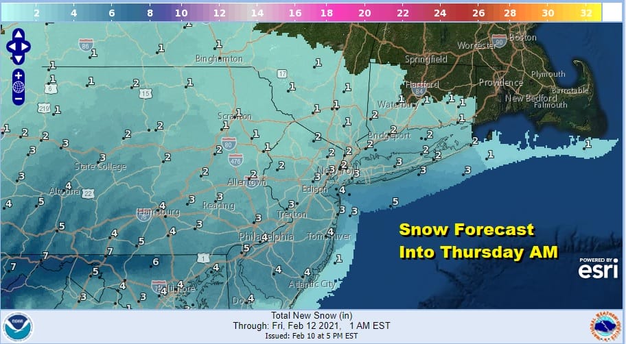
Overnight temperatures will be in the 20s so this will be more of powdery snow rather than a heavy wet one which should make it easier to clear in the morning. Snow amounts will average 2 to 3 inches with 4 inches or more south and 1 to 2 inches as you head north.
Look for leftover clouds later Thursday. High Temperatures will be in the upper 20s to some lower 30s. Another disturbance will pass to our south on Friday likely keeping us in clouds and only limited sunshine. Highs will be in the mid to upper 20s.

On to the next one Saturday as low pressure heads out of the Gulf States and makes it’s way to coastal Virginia. Clouds thicken up Saturday and snow and sleet develop Saturday afternoon into Saturday night. The low level temperatures will be cold but there may be some warm air aloft to put some sleet into the game. Highs will be in the 20s to near 30. I don’t think this changes to rain. It will simply end overnight into early Sunday morning. the precipitation with this looks a bit more blotchy in nature so we will deal with what that means as far as accumulations go after we are done with this one.
BE SURE TO DOWNLOAD THE FREE METEOROLOGIST JOE CIOFFI WEATHER APP &
ANGRY BEN’S FREE WEATHER APP “THE ANGRY WEATHERMAN!

MANY THANKS TO TROPICAL TIDBITS & F5 WEATHER FOR THE USE OF MAPS
Please note that with regards to any severe weather, tropical storms, or hurricanes, should a storm be threatening, please consult your local National Weather Service office or your local government officials about what action you should be taking to protect life and property.


