Winter Weather Advisory New Jersey South of Route 78
to Southeast Pennsylvania, Snow Tonight into Saturday Morning

Winter Weather Advisory New Jersey South of Route 78
to Southeast Pennsylvania, Snow Tonight into Saturday Morning
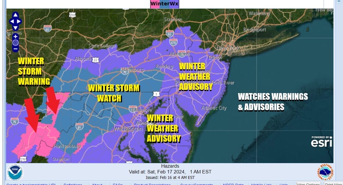
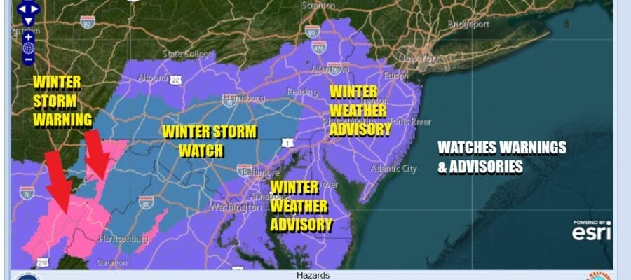
We have Winter Weather Advisories up for New jersey south of Route 78 as well as much of Eastern and Southeastern Pennsylvania. Winter Storm Watches continue across Southern & South Central Pennsylvania southwardinto Maryland, northwest of Washington and Baltimore. Low pressure is heading across the Central Appalachians and this low will move off the coast of the Delmarva Peninusla overnight. From there it will continue to the east northeast.

We are thinking that this will be a fast moving 6 hour or so event with snow amounts ranging from an inch to maybe two for areas just north of NYC including Northern NJ north of Route 80 to the Lower Hudson Valley (South of Route 4), 2 to perhaps 3 inches for Long Island and Northern New Jersey between Route 78 to Route 195. 3 to 4 inches likely south of Route 195 and west into Eastern, Southeastern, and South Central Pennsylvania. The Weather Prediction Center map above shows the probability of at least 2 inches.
SATELLITE WITH LIGHTNING STRIKES

WEATHER RADAR

Meanwhile this morning we continue to see windy conditions with gusts of 30 to 40 mph and that is thanks to an intensifying low moving off the coast of Maine and heading east. Snow is on the radar in North Central NY south to the Northwest Catskills. We will see some sunshine along with arriving clouds later today and temperatures this afternoon will be mostly in the 30s.

This is a minor system and there isn’t much room for upside due to the fast movement, but I would not surprise me if a few places finish above forecast amounts or at least at the high end of the range. Snow develops from west to east tonight as the low moves along and then ends from west to east around or shortly after daybreak Saturday. Temperatures overnight will be in the mid to upper 20s in most places. Saturday we will see leftover clouds and there could be some leftover snow showers around as the upper trough moves through. Most highs will be in the 30s. The rest of the President’s Day holiday weekend looks good with sunshine for both Sunday and Monday. Most high temperatures both days will be in the upper 30s to some lower 40s. Enjoy the holiday weekend.
BE SURE TO DOWNLOAD THE FREE METEOROLOGIST JOE CIOFFI WEATHER APP &
ANGRY BEN’S FREE WEATHER APP “THE ANGRY WEATHERMAN!
MANY THANKS TO TROPICAL TIDBITS FOR THE USE OF MAPS
Please note that with regards to any severe weather, tropical storms, or hurricanes, should a storm be threatening, please consult your local National Weather Service office or your local government officials about what action you should be taking to protect life and property.
(Amazon is an affilate of Meteorologist Joe Cioffi & earns commissions on sales.)