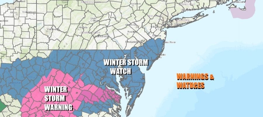
Winter Storm Watch Central & South Jersey
Ahead of Storm Passing To The South of Long Island

Winter Storm Watch Central & South Jersey
Ahead of Storm Passing To The South of Long Island
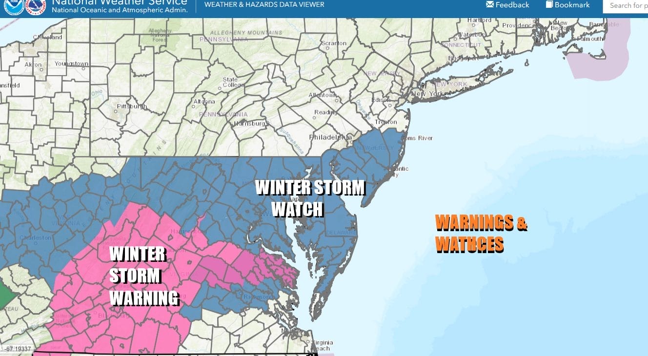
The busy and wintry weather pattern continues this week and we have the first of 3 storm systems to contend with. Winter Storm Warnings are up for parts of West Virginia and Virginia and additional winter storm warnings will likely go up later today and tonight. Winter Storm Watches cover much of Maryland, Delaware and the southern half of New Jersey from Ocean and Burlington counties southward.
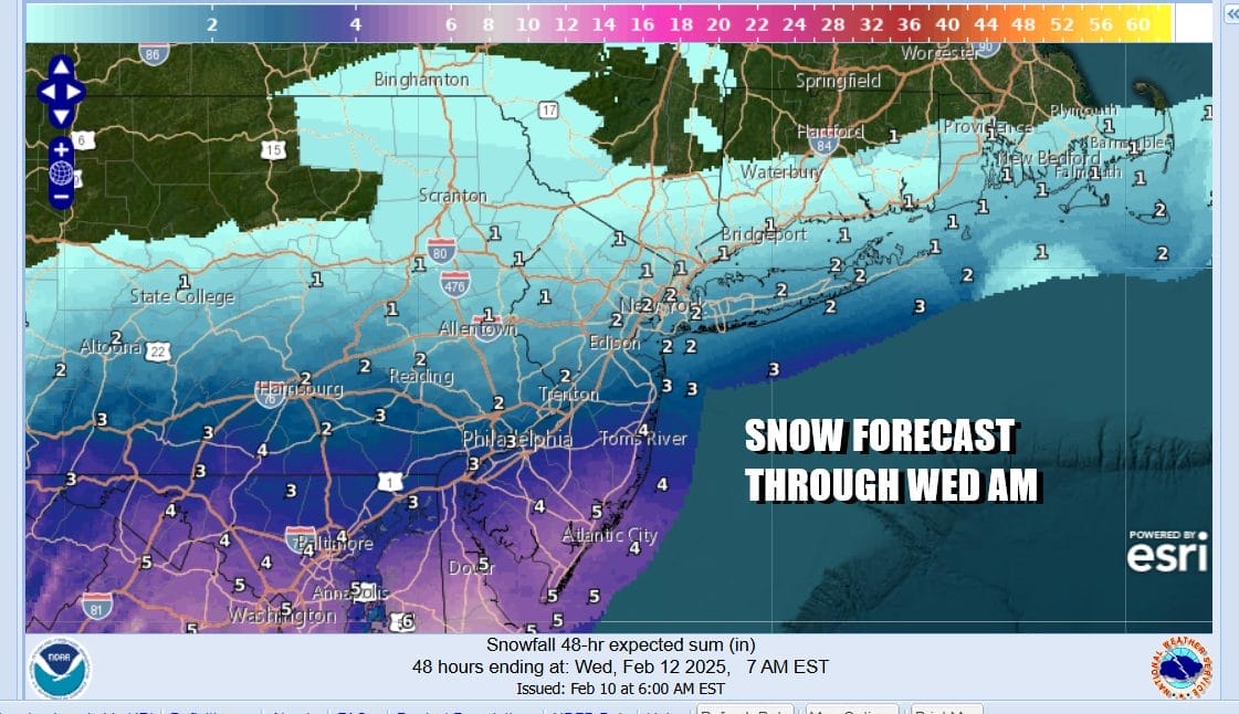
For Eastern Pennsylvania to Southern New England this system is going to have a sharp northern cutoff probably running across Southern Connecticut west to the Hudson Valley and Northern New Jersey. Accumulating snows of an inch or maybe 2 will reach as far north as Route 78 in New Jersey and Long Island. A coating of snow at most is likely as you head northward and then amounts pick up to a few inches south of Interstate 78 to Interstate 195. In the watch area we are looking at the possibility of 4 inches or more.
SATELLITE WITH LIGHTNING STRIKES

WEATHER RADAR

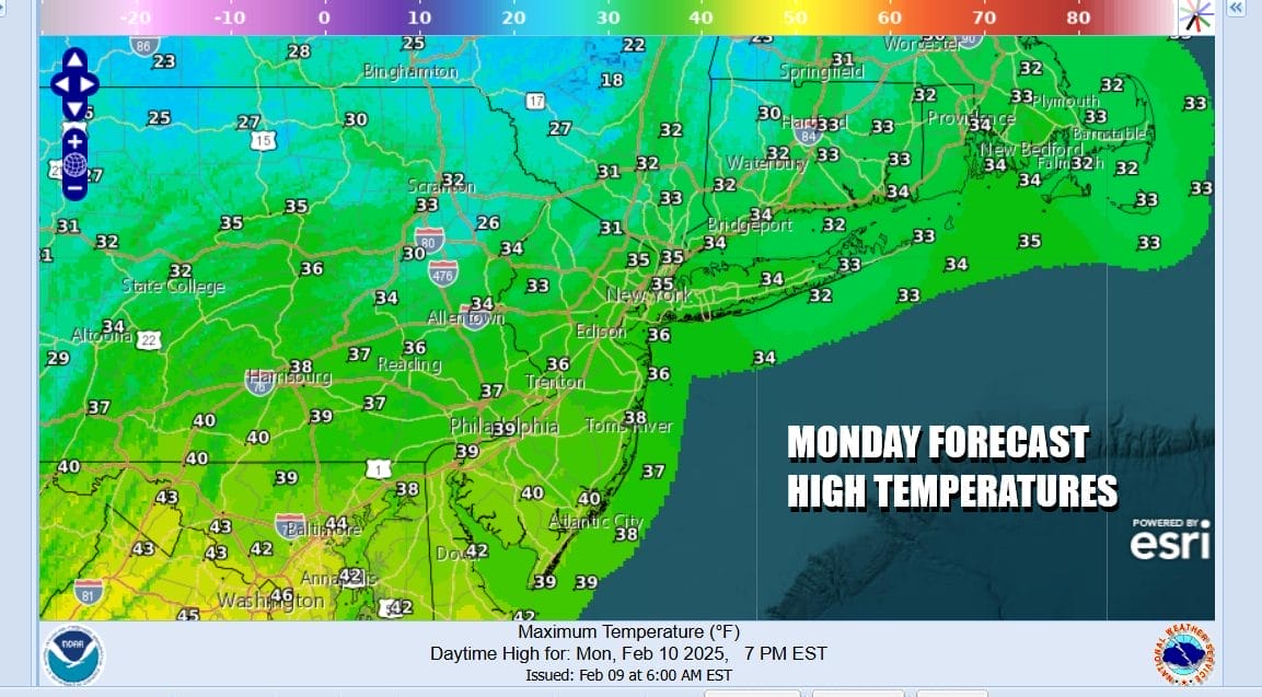
Today however it s a quiet but cold weather day across the Northeast and Middle Atlantic states. There are some clouds around as satellite loops show everything racing along from west to east. We could see some clouds increase later today or tonight but for the most part we will see some sunshine across Eastern Pennsylvania to Southern New England. Most highs today will be in the 30s.
A stalled frontal boundary lies from the Carolinas west to Tennessee and it is along this boundary that we see a wave develop and track straight to the east. The upper pattern is still strongly west to east so it will be hard for storms to gain latitude once they reach the Carolinas. That said we will se a band of moderate to occasionally heavy snow develop from Eastern Kentucky to Virginia Tuesday and it will be a matter of how far north this all gets late Tuesday into Tuesday night before it all slides to the east.

The snow area and the low pressure wave exits to the east later Tuesday night and that should bring an end to the snow. However right behind this system is the next storm system that will likely take a track to the west up the west side of the Appalachians. As soon as this one is done, snow will develop ahead of a warm front and that will pass through Wednesday night before changing to rain and then ending by Thursday morning.
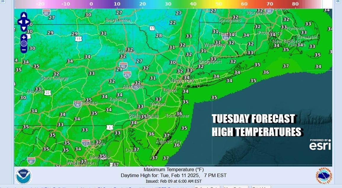
As far as temperatures are concerned, Tuesday temperatures will top in the 30s but once it starts snowing they should drop into the upper 20s and lower 30s just above everywhere. Snow will be gone before daybreak Wednesday but clouds will remain as the next system quickly moves in. Highs Wednesday will be in the 30s. Snow develops Wednesday night and the changes to rain. We could get a quick coating to a few inches ahead of the changeover. We will evaluate this in additional forecasts later today. Another complex storm system is set to arrive in time for the President’s Day holiday weekend.
BE SURE TO DOWNLOAD THE FREE METEOROLOGIST JOE CIOFFI WEATHER APP &
ANGRY BEN’S FREE WEATHER APP “THE ANGRY WEATHERMAN!
MANY THANKS TO TROPICAL TIDBITS FOR THE USE OF MAPS
Please note that with regards to any severe weather, tropical storms, or hurricanes, should a storm be threatening, please consult your local National Weather Service office or your local government officials about what action you should be taking to protect life and property.


