
Winter Storm Warnings Winter Weather Advisory Inland Heavy Rain Coast
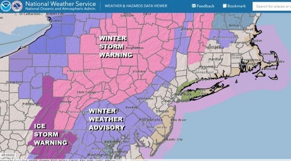
Winter Storm Warnings are up from Central and Northeast Pennsylvania northeast to the Catskills and throughout much of upstate NY and interior New England. Winter Weather advisories surround those winter storm warnings in Western New Jersey, Southeast and South Central Pennsylvania south into Maryland.
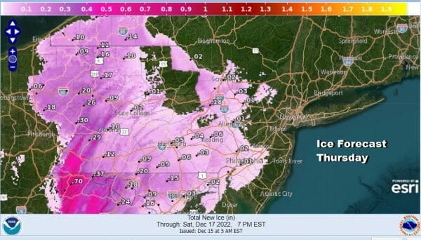
This is a situation where we have lots of moisture coming into marginally cold air and that will lead to heavy wet snows of generally 6 inches or more in areas under winter storm warnings. For winter weather advisories that are up on the southern edge of this, it will be for mainly some sleet and freezing rain before changing to rain.
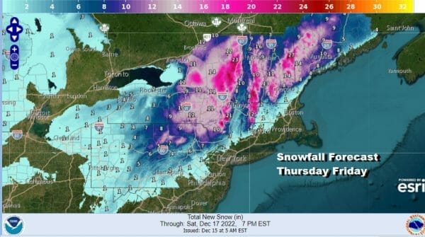
The satellite shows the moisture sweeping northward up the coast into the cold air lying between it and a storm that is southeast of Nova Scotia on the upper right. Radar is loaded with moisture as it lifts northward. This is going to be a long duration event as low pressure forms in the Carolinas and moves northward hugging the coast into Friday and then pulling away to the northeast.
SATELLITE

WEATHER RADAR

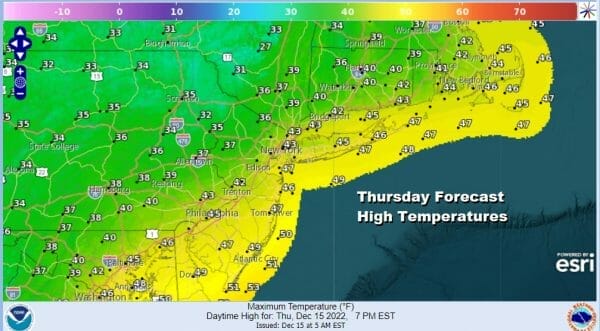
Warm air will sweep northward into NY State so a lot of areas could see heavy wet snow go over to sleet or even some rain while along the coast 1.5 to 2 inches or more of rain is forecast. Temperatures today will be in the 30s though it will reach into the 40s along the immediate coast.
Precipitation will continue tonight and through the daytime Friday as the low inches northeasward. We will start to see precipitation ending to the southwest of the low track but we may not see some genuine improvement until Saturday across much of Eastern Pennsylvania to Southern New England.

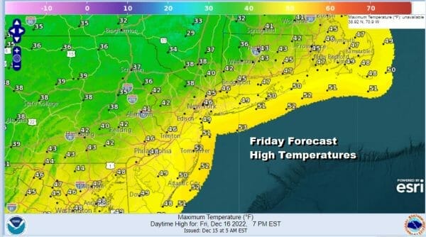
Temperatures Friday once again will be in the 30s inland and in the 40s along the coast. We should also mention that there will be some minor tidal flooding at high tide over the next 2 days given the track of the low but fortunately we are in between moon phases.
Over the weekend weather conditions will improve with some sun returning for Saturday though there could still be some clouds leftover early in the day. Sunday we will see some sunshine. Both days will be cold with highs just in the 30s. Next week we will be setting up for the arrival of a bitter cold arctic air mass at the end of the week and the question is whether the arrival of that bitter cold air comes with a major storm to usher it in. Stay tuned.
BE SURE TO DOWNLOAD THE FREE METEOROLOGIST JOE CIOFFI WEATHER APP &
ANGRY BEN’S FREE WEATHER APP “THE ANGRY WEATHERMAN!
MANY THANKS TO TROPICAL TIDBITS & F5 WEATHER FOR THE USE OF MAPS
Please note that with regards to any severe weather, tropical storms, or hurricanes, should a storm be threatening, please consult your local National Weather Service office or your local government officials about what action you should be taking to protect life and property.


