
Winter Storm Warning & Winter Weather Advisories
Eastern Pennsylvania to Southern New England

Winter Storm Warning & Winter Weather Advisories
Eastern Pennsylvania to Southern New England
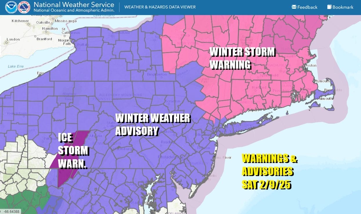
The latest winter storm is moving through the Northeast and Mid Atlantic states today producing all sorts of weather. Winter Storm Warnings are posted for most inland areas from NY to New England with Winter Winter Weather Advisories for Long Island and almost all of New Jersey save for Bergen & Passaic counties which are under Winter Storm Warnings.
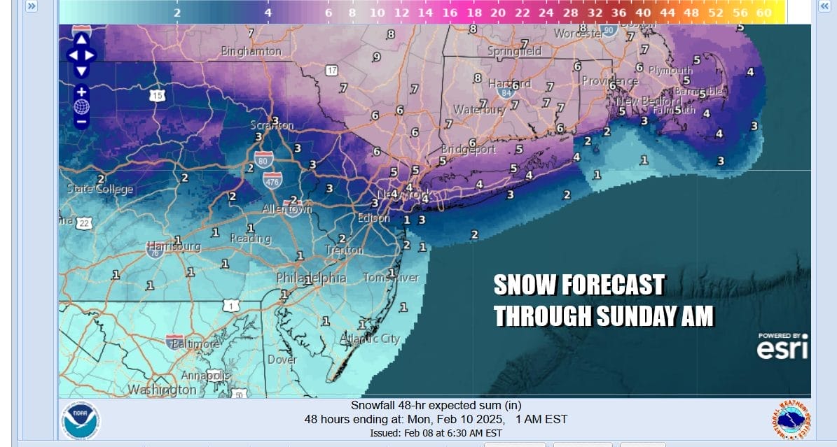
The National Weather Service snow forecast has not changed since last night. My only general view is that these snow amounts are too high for Long Island and Northern New Jersey and I would probably be more comfortable with an inch or 2 less than what is being advertised. For areas inland in the Winter Storm Warning zone I’m generally more comfortable with a 4 to 6 inch snowfall. Areas across Southern Pennsylvania and Central and South Jersey will see minimal snow and more in the way of sleet and freezing rain with some icing conditions developing especially in Pennsylvania which is seeing its second round of icing in 3 days.
SATELLITE WITH LIGHTNING STRIKES

WEATHER RADAR

We will begin to see precipitation spreading northeastward this afternoon reaching Philadelphia and nearby areas around 4 ot 5pm and New York City around 6 or 7pm. Snow will change quickly to sleet and freezing rain in Central and South Jersey and Southern Pennsylvania. Snow will change across NYC, Long Island and the lower Hudson Valley south of Interstate 84 between 11pm and 2am from south to north. For Connecticut it is an all snow event for the most part.
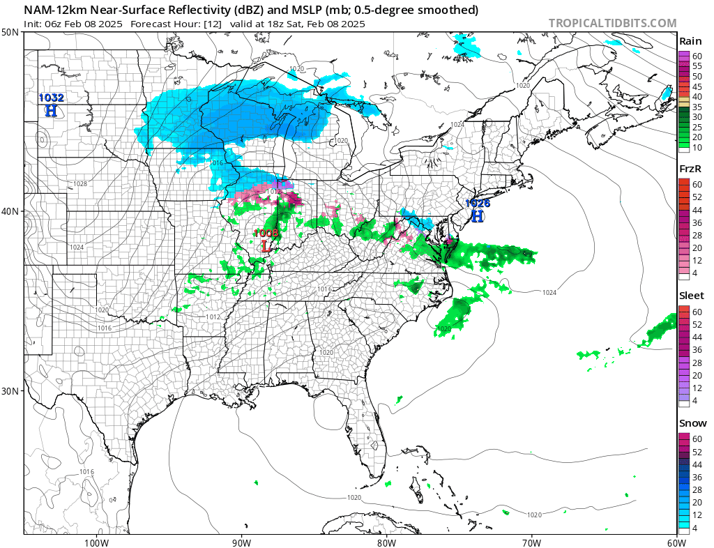
Low pressure moves out of Kentucky to West Virginia and then redevelops off the coast of Delaware and New Jersey overnight before moving away to the northeast Sunday morning. This will all come to an end overnight and we should see improving weather conditions Sunday. Temperatures today will be mostly in the 30s for highs. Where it is mostly snow or while it is snowing temperatures will settle in the upper 20s. Sunday look for partly sunny and breezy conditions with highs mostly in the mid to upper 30s. The storm parade continues next week with the next storm going by to the south Tuesday bringing potentially heavy snow to Virginia Maryland and Delaware but the northern fringe will reach Central and South Jersey. This storm is likely to slide underneath us to the south from what we are seeing at the moment.
BE SURE TO DOWNLOAD THE FREE METEOROLOGIST JOE CIOFFI WEATHER APP &
ANGRY BEN’S FREE WEATHER APP “THE ANGRY WEATHERMAN!
MANY THANKS TO TROPICAL TIDBITS FOR THE USE OF MAPS
Please note that with regards to any severe weather, tropical storms, or hurricanes, should a storm be threatening, please consult your local National Weather Service office or your local government officials about what action you should be taking to protect life and property.


