Wind Advisory A Coating to a Couple of Inches of Snow Inland
As Strong Storm Moves Across Southern Canada

Wind Advisory A Coating to a Couple of Inches of Snow Inland
As Strong Storm Moves Across Southern Canada

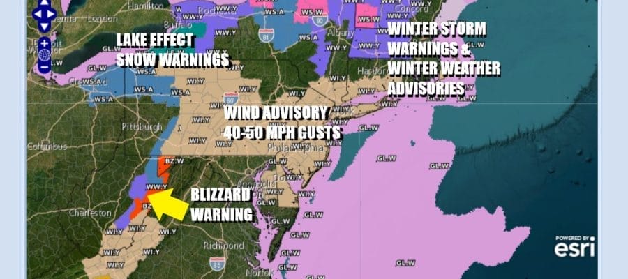
A powerful storm will be moving across Southern Canada and Northern New England Wednesday night and Thursday and it will produce a wide variety of winter weather from the Central Appalachians to Northern New England. Snow is going to be a bigger problem over a wider area and we once again have Lake Effect Snow Warnings from Northeast Ohio to North Central NY. Also we have numerous Winter Storm Warnings & Winter Weather Advisories across NY State to Northern New England. We also have Blizzard Warnings posted for the Central Appalachians in West Virginia where snow and wind will combine to create whiteout conditions there tonight into Thursday. Wind Advisories are also posted for much of the Northeast into the Mid Atlantic Thursday for west to northwest winds gusting to 50 mph at times.
SATELLITE WITH LIGHTNING STRIKES

WEATHER RADAR

We don’t see much going on during today though snow will begin to break out across Ohio and Western NY and then head east. For Eastern Pennsylvania to Southern New England today it is a day of increasing clouds with high temperatures mostly in the 30s to around 40 degrees. Southwest winds will pick up to 15 to 20 mph with higher gusts later today into tonight.

This low will move eastward near the Canadian border tonight and strengthening along the way. Notice that the lines of equal pressure or isobars on the map become very tight indeed indicating a tight pressure gradient. This is going to whip up the west to northwest wind Thursday across a wide area of the Northeast and Mid Atlantic with 50 mph wind gusts.
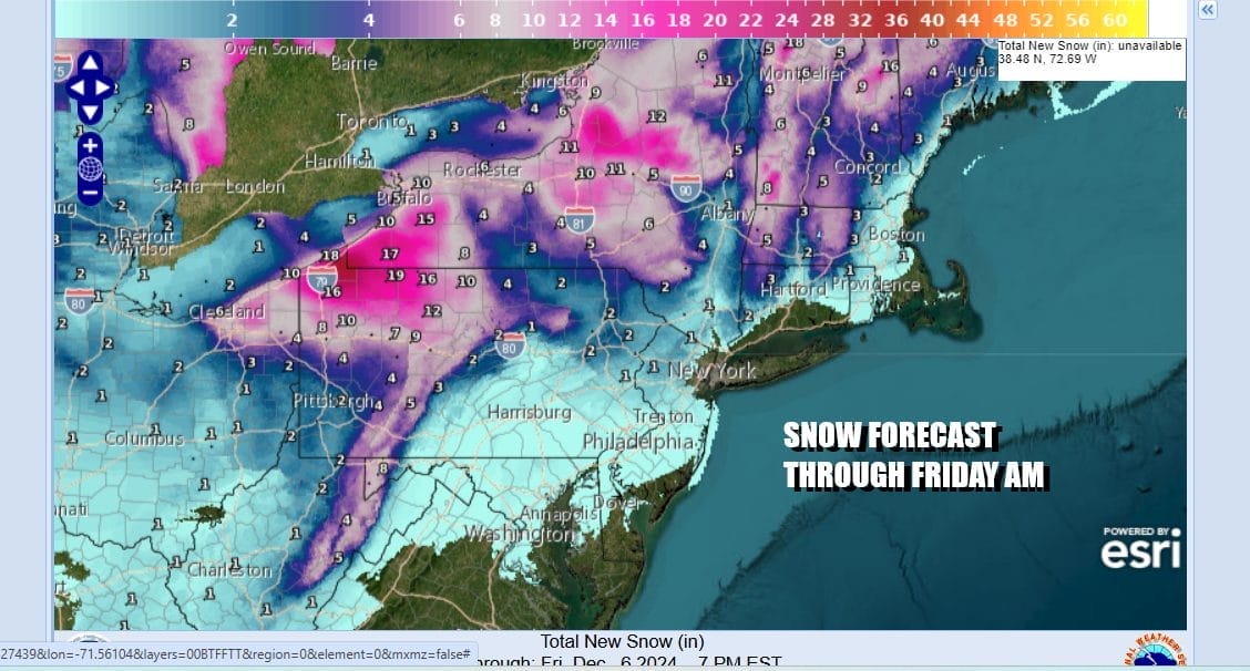
The Lake Effect snow machine goes on again from Northeast Ohio to Northwest Pennsylvania, Western NY as well as Central and North Central NY where 1 to 2 feet is forecast. On the southern end of this across Eastern Pennsylvania we are talking about a coating to maybe a couple of inches inland in Northwest New Jersey and Northeast Pa as well as the Hudson Valley and Connecticut north of route 84.
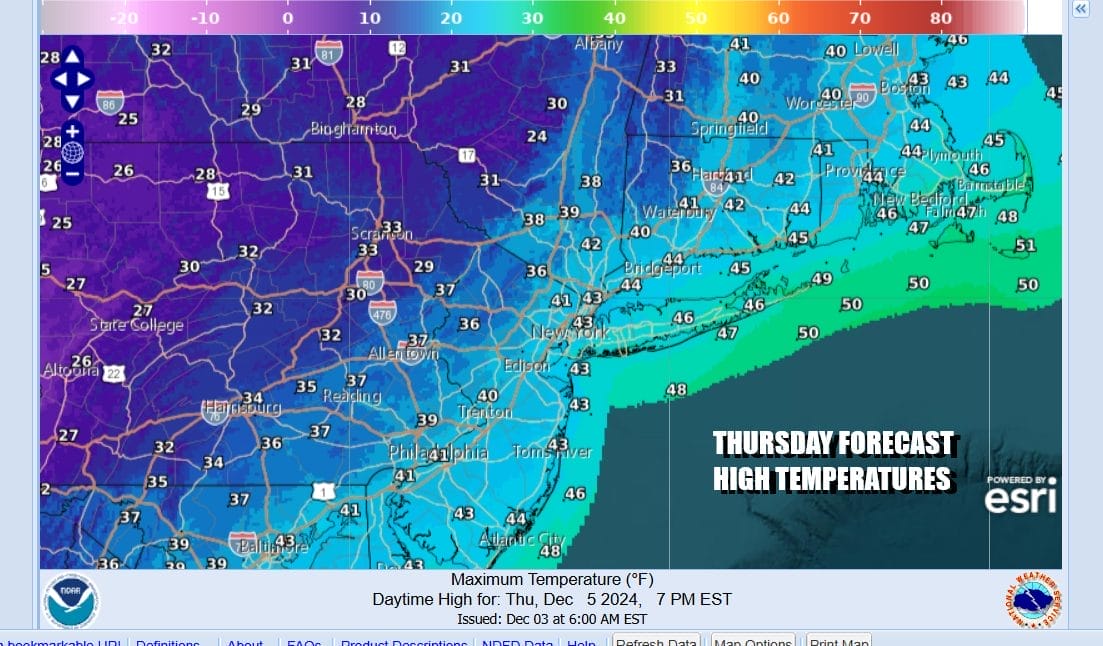
Most of the snow will play out in bands of rain changing to snow into Thursday morning followed by windy and cold conditions. Temperatures will settle in the upper 30s to some lower 40s for highs and then head down to the teens and 20s Friday morning. Couple this with the strong wind gusts and you will see wind chills drop to the teens and low 20s. Friday dayside will be very cold with sunshine and gusty wind. Highs just in the low to mid 30s at best.

Weather conditions will likely settle down over the weekend with sunshine for Saturday and most of Sunday. Highs will be in the mid 30s to around 40 Saturday and in the low to mid 40s Sunday. Lower pressures from the west and south will arrive Monday with rain along with milder temperatures. Much of next week will see temperatures going a little above average as the cold weather pattern of the last 10 days takes a break.
BE SURE TO DOWNLOAD THE FREE METEOROLOGIST JOE CIOFFI WEATHER APP &
ANGRY BEN’S FREE WEATHER APP “THE ANGRY WEATHERMAN!
MANY THANKS TO TROPICAL TIDBITS FOR THE USE OF MAPS
Please note that with regards to any severe weather, tropical storms, or hurricanes, should a storm be threatening, please consult your local National Weather Service office or your local government officials about what action you should be taking to protect life and property.


