
Weekend Weather Improvement

MENTION JOE CIOFFI AND GET A 5% DISCOUNT
Weekend Weather Improvement
Skies Brighten Saturday With Passing Showers
Sunday Showers Early Then PM Sun
At least this long miserable week of clouds and on and off rain is finally coming to an end . We are going to see Weekend Weather Improvement but it is going to be a slow process and it is not going to be picture perfect. First off there is still a lot of moisture still left around which mean there will be lots of clouds around tonight and on Saturday. There will be some passing brief showers going forward from here but during the day Saturday there will be some brightening of skies. Temperatures at least should get back into the 60s during Saturday.
Weekend Weather Improvement
NAM Model Saturday Evening
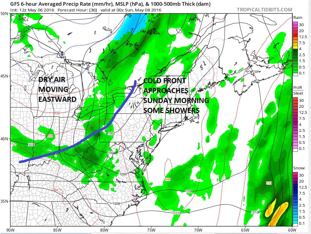
Sunday morning there could be a few passing showers with the approaching cold front. That front finally cleans house around here as it sweeps all the moisture and marine air out of here. By mid morning or certainly by Sunday afternoon it should go partly sunny. Temperatures will be in the 60s. I think we will have a nice start to next week with some sunshine on Monday with highs in the upper 60s to lower 70s.
With regards to Tuesday and beyond it will hinge on whether an onshore flow sets up again. Models have been bouncing back and forth on this idea for the last few days. Today’s European model suggests a compromise where high pressure builds down from the north with some New England dry air but the frontal boundary and the rain will be close by especially Tuesday night into Wednesday. It may lie across Southern New Jersey and points southward. Its kind of a tough call a this point. But at least we have some slow improvement to look forward to over the weekend and into Monday so lets enjoy that.
FiOS1 News Weather Forecast For Long Island
FiOS1 News Weather Forecast For New Jersey
FiOS1 News Weather Forecast For Hudson Valley
NATIONAL WEATHER SERVICE SNOW FORECASTS
LATEST JOESTRADAMUS ON THE LONG RANGE

NOMINATED FOR AN APPY AWARD FOR BEST WEATHER APP!!
Weather App

Don’t be without Meteorologist Joe Cioffi’s weather app. It is really a meteorologist app because you get my forecasts and my analysis and not some automated computer generated forecast based on the GFS model. This is why your app forecast changes every 6 hours. It is model driven with no human input at all. It gives you an icon, a temperature and no insight whatsoever.
It is a complete weather app to suit your forecast needs. All the weather information you need is right on your phone. Android or I-phone, use it to keep track of all the latest weather information and forecasts. This weather app is also free of advertising so you don’t have to worry about security issues with your device. An accurate forecast and no worries that your device is being compromised.
Use it in conjunction with my website and my facebook and twitter and you have complete weather coverage of all the latest weather and the long range outlook. The website has been redone and upgraded. Its easy to use and everything is archived so you can see how well Joe does or doesn’t do when it comes to forecasts and outlooks.
Just click on the google play button or the apple store button on the sidebar for my app which is on My Weather Concierge. Download the app for free. Subscribe to my forecasts on an ad free environment for just 99 cents a month.
Get my forecasts in the palm of your hand for less than the cost of a cup of Joe!
![]()

