
Weather Models Downgrade Snow Threat

MENTION JOE CIOFFI AND GET A 5% DISCOUNT
For many days beginning last weekend weather models were advertising possibilities along the east coast. And for many days I stood skeptical and took a strong stand against it all for a number of reasons. This has been going on all winter with models showing major storms only to back away. The only exception was the Blizzard 2016 back in January. All the systems evolved in pretty much the same way except that was the only time the upper lined up to create an intense storm close enough to the coast. I stood against it until 3 runs of the European in a row convinced me on Wednesday morning that something was going to happen. Of course right after that the rug began to get pulled out starting with the NAM model and going from there. It appears at this point that anything we get out of this is going to be minimal. National Weather Service snowfall forecasts are too high even though they lowered. Only the European and Canadian models this morning are showing snows of up to a few inches, and frankly I am highly doubtful at this point about that.
Weather Models Downgrade Snow Threat
Satellite Loop
The satellite loop shows what is happening. You can see three distinct areas of clouds with one approaching the east coast. A second flare up of storms in the western Gulf and a third twist of clouds over the upper Midwest. This illustrates the problem that has been happening all along. All this energy is running around and each one impacts the other. Models time things out differently every run. There is still a fourth disturbance in Canada that is going to get involved with this on Sunday and instead of lifting all this up, it winds up kicking it out!

Radar is showing some precipitation to the south moving across Northern Virginia and touching Southern Pennsylvania. That first area should stay south of us though clouds will move in to Southern areas of Pennsylvania and Southern New Jersey with rain or a few wet snowflakes getting close to those areas, at least aloft later today and tonight.
Weather Models Downgrade Snow Threat
Radar Loop

Weather Models Downgrade Snow Threat
Local Radar Loops


It looks to me like southern areas could see some spotty light precipitation tonight and Sunday, gradually spreading northeastward but Im thinking that whatever comes up will be mostly light rain, maybe mixing with some wet snow late Sunday into Sunday evening. Little accumulation is forecast for most areas except maybe a coating to an inch in one or two odd areas along the coast…if that ! I’m inclined to believe we get little or nothing out of this and given that temperatures are going to be warmer with the absence of major storm developing, this is now much ado about nothing. Temperatures will be mostly in the 40s Sunday.
Monday we will see sunshine with highs in the 40s. Then a nice warmup into the middle of next week with highs reaching the 60s to near 70 by Thursday.
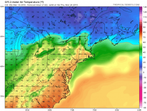
Weather Models Downgrade Snow Threat
Temperature Forecasts Thursday Afternoon
FiOS1 News Weather Forecast For Long Island
FiOS1 News Weather Forecast For New Jersey
FiOS1 News Weather Forecast For Hudson Valley
NATIONAL WEATHER SERVICE SNOW FORECASTS
LATEST JOESTRADAMUS ON THE LONG RANGE
Weather App

Don’t be without Meteorologist Joe Cioffi’s weather app. It is really a meteorologist app because you get my forecasts and my analysis and not some automated computer generated forecast based on the GFS model. This is why your app forecast changes every 6 hours. It is model driven with no human input at all. It gives you an icon, a temperature and no insight whatsoever.
It is a complete weather app to suit your forecast needs. All the weather information you need is right on your phone. Android or I-phone, use it to keep track of all the latest weather information and forecasts. This weather app is also free of advertising so you don’t have to worry about security issues with your device. An accurate forecast and no worries that your device is being compromised.
Use it in conjunction with my website and my facebook and twitter and you have complete weather coverage of all the latest weather and the long range outlook. The website has been redone and upgraded. Its easy to use and everything is archived so you can see how well Joe does or doesn’t do when it comes to forecasts and outlooks.
Just click on the google play button or the apple store button on the sidebar for my app which is on My Weather Concierge. Download the app for free. Subscribe to my forecasts on an ad free environment for just 99 cents a month.
Get my forecasts in the palm of your hand for less than the cost of a cup of Joe!
![]()
![]()
<


