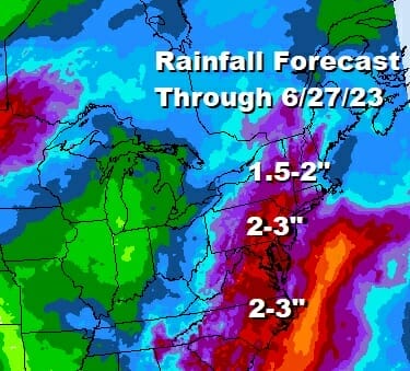

Waves Of Rain Thunderstorms Moving Up The East Coast Next Several Days
The onshore flow is all set up and now we sit back and watch an upper air storm system in the Tennessee Valley meander around for another couple of days before it starts to turn northeastward. In the meantime the upper flow is turing to the south and this is going to be the beginning of days of rain. When it is all said and done some areas will wind up with several inches of rain but it will be spread out over the next 7 days. There will be a chance for some rain each day from now through next Tuesday 6/27/2023!

This is not to say that it rains every minute for 7 days. To the contrary we will see the rain come up in waves from the south starting today as it will be touching Southern New Jersey and Southern Pennsylvania as the radar shows this morning. To the north clouds will be increasing and rain will move northward through New Jersey and Eastern Pennsylvania tonight and reaching the Hudson Valley and Southern New England overnight.
SATELLITE

WEATHER RADAR

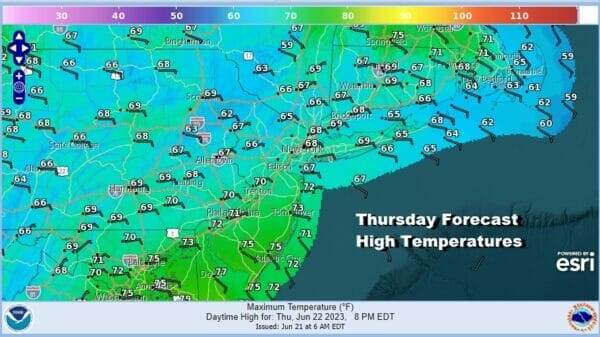
While this is all going on today with the advancement of clouds moving north and rain not far behind, whatever sun we see will be limited. The east wind will be an issue and that will hold temperatures down considerably. Look for highs along the coast probably not out of the 60s and inland highs only back to the upper 60s and lower 70s at best.

The first wave of rain that comes through tonight into Thursday morning will move to the northeast. Then there will likely be a bit of a break before another wave of rain moves northward later Thursday and Thursday night. There might also be a thunderstorm in the mix. Again the east wind will prevail with the onshore flow so look for highs Thursday in many areas having a tough time getting out of the 60s.
Starting Friday the upper low begins to move north and northeastward. This will turn the surface winds more to the south and the rain will become more showery in nature. Friday through Sunday we will see 3 days where the mornings might start out dry, but then areas of showers and thunderstorms will develop. Some areas in Eastern Pennsylvania to Southern New England will see more rain than others and it is not going to be continuous. Highs will be in the mid to upper 70s Friday and inland highs should reach into the 80s over the weekend with 70s along the coast. The song remains the same for Monday and Tuesday as a cold front swings east from the Great Lakes and that will likely mean the risk for more showers and thunderstorms on both days. We may finally see some improvement by the middle of next week.
BE SURE TO DOWNLOAD THE FREE METEOROLOGIST JOE CIOFFI WEATHER APP &
ANGRY BEN’S FREE WEATHER APP “THE ANGRY WEATHERMAN!
MANY THANKS TO TROPICAL TIDBITS FOR THE USE OF MAPS
Please note that with regards to any severe weather, tropical storms, or hurricanes, should a storm be threatening, please consult your local National Weather Service office or your local government officials about what action you should be taking to protect life and property.
(Amazon is an affilate of Meteorologist Joe Cioffi & earns commissions on sales.)


