
Warm Humid Day But Cooler Dry Air Starts to Arrive Thursday Weekend Outlook
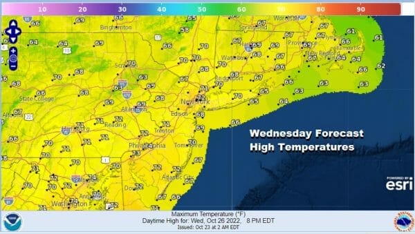
We still have some work to do before we get out of this warm humid air mass. Overnight we see dense fog develop and some areas will struggle to get rid of that today. Other areas may see brightening of skies and even some sun could brea through. Temperatures will be in the 70s for highs. To the east we are seeing moisture from the tropicsl streaming northward and that is bringing showers to Southeastern New England while the front to the west has rain that will pass well west and north. We don’t expect much in the way of showers from this front today. We will throw in the chance there could be some scattered showers late today when the front passes but the chances appear low.
SATELLITE

WEATHER RADAR

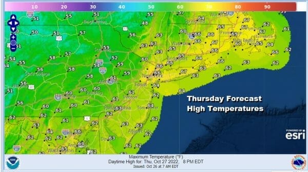
Skies will clear out tonight with lows in the upper 40s inland and low to mid 50s coast and warmer urban areas. High pressure over the Great Lakes will build into the northeast and it looks to hang around into the weekend. Initially there will be some leftover warmer air around for Thursday so the sunshine will take highs to the low and middle 60s along with a nice northwest breeze.
Thursday night will be nice and clear with lows in the 30s inland and low to mid 40s coast and warmer urban areas. Friday will be a nice day with sunshine however there will be some high clouds around thanks to lower pressures to the south and a system developing off the Florida coast. This system will meander off the southeast coast for a few days so we don’t expect issues from this through the weekend. Friday highs will be mostly in the 50s.

The weekend is looking good with sunshine for Saturday and sunshine giving way to arriving clouds Sunday. Saturday highs will be in the 50s to near 60 and Sunday highs will be in the upper 50s and lower 60s. Sunday night and Monday that meandering low to the south will start to move north and we will have a low coming out of Texas and heading for the west side of the Appalachians. This will probably bring the chance for some rain later Sunday night and Monday.
BE SURE TO DOWNLOAD THE FREE METEOROLOGIST JOE CIOFFI WEATHER APP &
ANGRY BEN’S FREE WEATHER APP “THE ANGRY WEATHERMAN!
MANY THANKS TO TROPICAL TIDBITS & F5 WEATHER FOR THE USE OF MAPS
Please note that with regards to any severe weather, tropical storms, or hurricanes, should a storm be threatening, please consult your local National Weather Service office or your local government officials about what action you should be taking to protect life and property.


