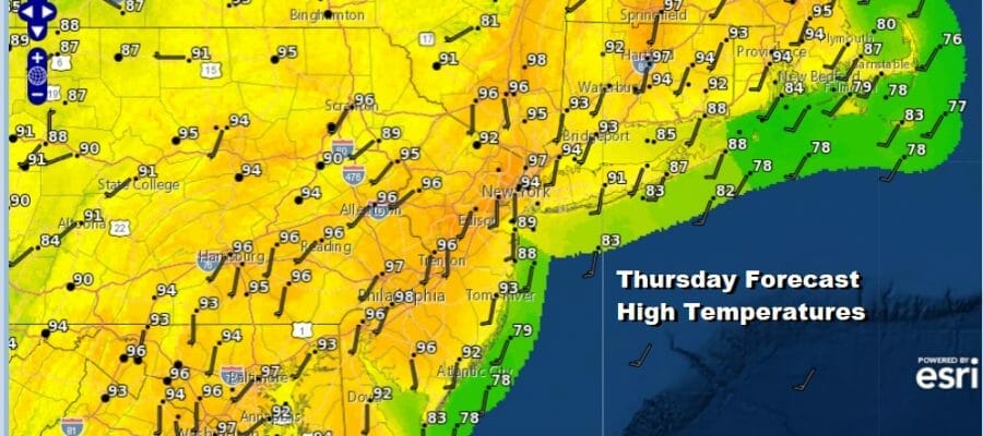
Very Hot Very Humid Highs 95 to 100 Some Thunderstorm Risk Friday
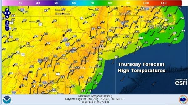
Today is the hottest weather day of the week and it is coming in combination with very high humidity. Dew points will be above 70 everywhere and it will be like living inside a hot wet sponge. We will have cloud free skies for most of the day with sunshine taking highs up to the mid 90s to near 100 degrees. The hottest temperatures will be around and to the west of the warmer urban settings like NYC, Newark, and Boston. Also it will be close to 100 to the west of the Route 1 Corridor in New Jersey.
SATELLITE

WEATHER RADAR

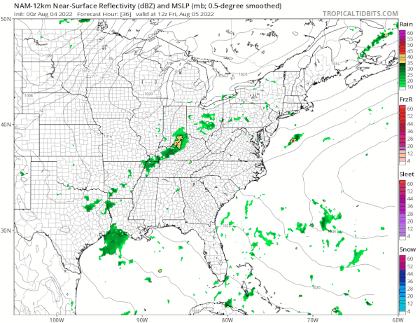
All this heat and humidity should create an unstable atmosphere but the mechanism to trigger off thunderstorms will be well inland in Pennsylvania and north in parts of Upstate NY where there are risks for isolated severe thunderstorms. Other than an isolated shower or thunderstorm, for much of the area we will be rain free. Some patchy clouds will be around tonight with lows in the mid to upper 70s.
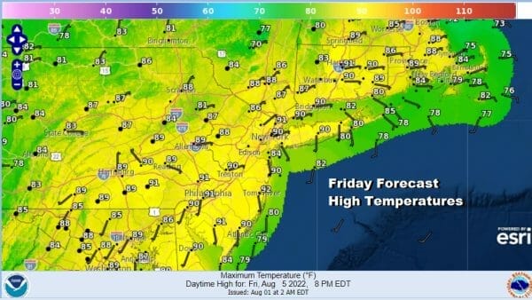
Friday will be hot and humid but it will be a solid 5 to 7 degrees lower than today. Most highs will be in the lower 90s. We will have sunshine but clouds will develop as a cold front nears. That front should produce some scattered thunderstorms late in the day Friday into Friday night. There should be more in the way of downpours and thunderstorms around giving more of the area the chance for at least some rain.
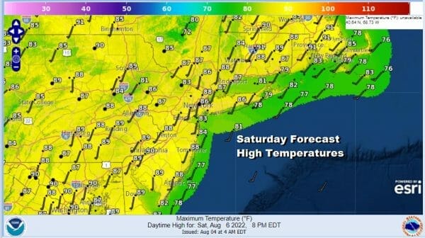
This weather front will move through and then completely fall apart. This means that we can’t even get humidity relief this weekend. In fact humidity levels will be high on Saturday and ridiculously high on Sunday. The remnant corpse of this cold front could help to set off scattered thunderstorms Saturday but they are likely to be few and far between. Otherwise it is clouds and sun with highs in the upper 80s to around 90 in most places.
Sunday dew points are going to be so high you will be able to cut it with a knife. We will see dew points in the low to mid 70s. On top of that temperatures will likely top out between 90 and 95 degrees with sunshine and low chances for scattered thunderstorms.

Next week starts hot and humid for Monday and Tuesday and another weather front approaches late Tuesday bringing with it some thunderstorms. This front has some drier air behind it so we could see some humidity relief provided the front keeps on moving.
BE SURE TO DOWNLOAD THE FREE METEOROLOGIST JOE CIOFFI WEATHER APP &
ANGRY BEN’S FREE WEATHER APP “THE ANGRY WEATHERMAN!
MANY THANKS TO TROPICAL TIDBITS & F5 WEATHER FOR THE USE OF MAPS
Please note that with regards to any severe weather, tropical storms, or hurricanes, should a storm be threatening, please consult your local National Weather Service office or your local government officials about what action you should be taking to protect life and property.


