
Tropical Storm Ida continues to meander out in the South Central Atlantic as it is moving east southeast right now at a very slow rate of speed. Steering currents have collapsed and IDA remains the prisioner of an upper trough which is distorting the cyclone though it seems to be holding together enough to maintain tropical storm strength. All the models forecast this trough to lift our and a ridge to replace it relaxing the shear. Conditions should become favorable for gradual strengthening and all the global models seem to show this right now so it is possible Tropical Storm Ida could become a hurricane in a few days assuming that trough lifts out. The drifting motion will continue for awhile until the ridge begins to build and that will allow Tropical Storm Ida to resume a northwest or north northwest course.
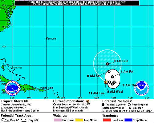
SUMMARY OF 1100 AM AST...1500 UTC...INFORMATION
-----------------------------------------------
LOCATION...20.5N 47.5W
ABOUT 1030 MI...1655 KM E OF THE NORTHERN LEEWARD ISLANDS
MAXIMUM SUSTAINED WINDS...45 MPH...75 KM/H
PRESENT MOVEMENT...ESE OR 120 DEGREES AT 8 MPH...13 KM/H
MINIMUM CENTRAL PRESSURE...1005 MB...29.68 INCHES
The loop is interesting because you can see the strong upper low north of Puerto Rico and how it is pulling clouds to the west across the western edge of the circulation of Tropical Storm Ida. You can also see the westerly shear to the north of the storm as those clouds blow away to the east. There appears to be a ball of convection however sitting closer to the circulation center which is helping Ida to maintain strength.


The visible satellite loop above shows the extent of clouds along the east coast and the onshore flow. Off the Carolinas you can a concentration of showers and thunderstorms there near where low pressure is located. Conditions could become favorable for some development over the next few days as this lows meaders about. High pressure to the north is interacting with the low to the south to produce the onshore flow and gusty winds that we are seeing here along with cloud cover. Marine conditions from Southern New England southward are not very good with rough ocean seas of 6 feet or higher and that will continue into Wednesday. Check the latest marine forecast for our area and the local forecast for what it all means. Small Craft Advisories are posted from Southern New England southward to the middle Atlantic states into Wednesday.
Be sure to download my weather app and subscribe to my forecasts. The app is free and the subscription is just 99 cents a month. The app is free of advertisement and there are no tracking or security issues.