Tropical Storm Darby Hits Hawaii
Tropical Storm Darby Hits Hawaii
While things have been quiet in the Atlantic Tropics for the last 5 weeks the Pacific has been busy producing 7 named storms in the last 3 weeks. Tropical Storm Darby has survived the trip across the East Central Pacific and is looking to move directly over the entire Hawaiian Island chain.
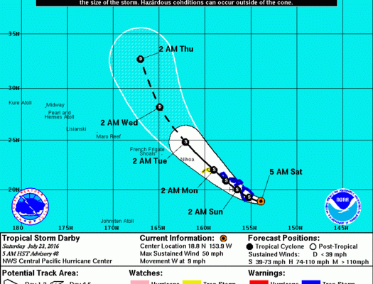
...DARBY TRACKING SLOWLY TOWARD THE BIG ISLAND...


SUMMARY OF 800 AM HST...1800 UTC...INFORMATION
----------------------------------------------
LOCATION...18.8N 154.3W
ABOUT 80 MI...130 KM SE OF HILO HAWAII
ABOUT 295 MI...475 KM ESE OF HONOLULU HAWAII
MAXIMUM SUSTAINED WINDS...50 MPH...85 KM/H
PRESENT MOVEMENT...W OR 275 DEGREES AT 9 MPH...15 KM/H
MINIMUM CENTRAL PRESSURE...1002 MB...29.59 INCHES


WATCHES AND WARNINGS
--------------------
CHANGES WITH THIS ADVISORY:

None.

SUMMARY OF WATCHES AND WARNINGS IN EFFECT:

A Tropical Storm Warning is in effect for...
* Hawaii County
* Maui County, including the islands of Maui, Molokai, Lanai and
Kahoolawe
* Oahu

A Tropical Storm Watch is in effect for...
* Kauai

A Tropical Storm Warning means that tropical storm conditions are
expected within the warning area within 36 hours.

A Tropical Storm Watch means that tropical storm conditions are
possible within the watch area within 48 hours.

Interests in the eastern portion of the Papahanaumokuakea Marine
National Monument should monitor the progress of Darby.

For storm information specific to your area, please monitor
products issued by the National Weather Service office in
Honolulu.


DISCUSSION AND 48-HOUR OUTLOOK
------------------------------
At 800 AM HST (1800 UTC), the center of Tropical Storm Darby was
located by aircraft and radar near latitude 18.8 North, longitude
154.3 West. Darby is moving toward the west near 9 mph (15 km/h).
Darby's forward motion is expected to slow slightly today followed
by a gradual turn toward the northwest tonight and Sunday. On the
forecast track, the center of Darby is forecast to pass over the Big
Island later today and close to Maui County tonight. Darby will
approach Oahu on Sunday and Kauai Monday.

Maximum sustained winds are near 50 mph (85 km/h) with higher gusts.
Some weakening is forecast during the next 48 hours.

Tropical-storm-force winds extend outward up to 125 miles (205 km)
from the center.

The estimated minimum central pressure is 1002 mb (29.59 inches).


HAZARDS AFFECTING LAND
----------------------
WIND:  Tropical storm force winds are expected over the Big Island
today, over portions of Maui County this afternoon and evening, and
over Oahu Sunday. Tropical storm force winds are possible over Kauai
Monday.

SURF:  Swells generated by Darby are expected to impact the
Hawaiian Islands over the next couple of days.

RAINFALL:  Storm total rainfall of 10 to 15 inches, with possible
isolated maximum amounts of 20 inches. These rains could
produce life-threatening flash floods and landslides.

It appears based on the satellite loops that Darby actually seems to be maintaining strength. There even looks like there has been an increase in convection around the well defined circulation. The center is forecast to pass very close or over the entire Hawaiian chain as a tropical storm which is a pretty rare occurrence.

You can watch the storm circulation on the real time radar loop above.
FiOS1 News Weather Forecast For Long Island
FiOS1 News Weather Forecast For New Jersey
FiOS1 News Weather Forecast For Hudson Valley
NATIONAL WEATHER SERVICE SNOW FORECASTS
LATEST JOESTRADAMUS ON THE LONG RANGE
Weather App

Don’t be without Meteorologist Joe Cioffi’s weather app. It is really a meteorologist app because you get my forecasts and my analysis and not some automated computer generated forecast based on the GFS model. This is why your app forecast changes every 6 hours. It is model driven with no human input at all. It gives you an icon, a temperature and no insight whatsoever.
It is a complete weather app to suit your forecast needs. All the weather information you need is right on your phone. Android or I-phone, use it to keep track of all the latest weather information and forecasts. This weather app is also free of advertising so you don’t have to worry about security issues with your device. An accurate forecast and no worries that your device is being compromised.
Use it in conjunction with my website and my facebook and twitter and you have complete weather coverage of all the latest weather and the long range outlook. The website has been redone and upgraded. Its easy to use and everything is archived so you can see how well Joe does or doesn’t do when it comes to forecasts and outlooks.
Just click on the google play button or the apple store button on the sidebar for my app which is on My Weather Concierge. Download the app for free. Subscribe to my forecasts on an ad free environment for just 99 cents a month.
Get my forecasts in the palm of your hand for less than the cost of a cup of Joe!