
SUMMARY OF 500 PM AST...2100 UTC...INFORMATION
----------------------------------------------
LOCATION...11.5N 42.0W
ABOUT 1325 MI...2130 KM E OF THE LESSER ANTILLES
MAXIMUM SUSTAINED WINDS...50 MPH...85 KM/H
PRESENT MOVEMENT...W OR 280 DEGREES AT 10 MPH...17 KM/H
MINIMUM CENTRAL PRESSURE...1000 MB...29.53 INCHES


WATCHES AND WARNINGS
--------------------
There are no coastal watches or warnings in effect.
 Latest satellite trends this afternoon shows that Danny has not changed all that much. After a convective burst earlier today it seems to have died out for now and the circulation is inside the cloud that extend back to the African coast. For now the National Hurricane Center is leaving things the same with top winds at 50 mph. Dry air is getting entrained in the circulation so this is going to be an issue going forward as is the Saharan dust among other things. At this stage we are basically going to look at this a day at a time. The European this afternoon shows a weaker system that moves further west while the GFS develops a deeper system that moves further north! God forbid they should agree.
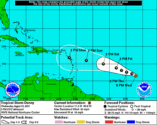
The hurricane center forecast is pretty much consistent with prior forecasts which takes it to hurricane status but not much beyond a category 1 at this point.