Tropical Depression 19 Tropical Storm Watch Southeast Florida
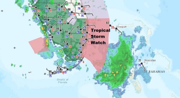
Disturbed weather off the east coast of Florida has been getting better organized all day long. Low pressure has formed and we now have Tropical Depression 19. Tropical Storm Watch is posted for Southeast Florida from Jupiter Inlet south to Ocean Reef which includes Miami, Fort Lauderdale, and West Palm Beach. Satellite pictures show most of the convection is east of the center so the weather in South Florida right now is relatively calm but that will change overnight as the depression heads to the west and rains begin to spread inland.

5PM LOCATION…25.4N 79.0W
ABOUT 80 MI…130 KM ESE OF MIAMI FLORIDA
MAXIMUM SUSTAINED WINDS…35 MPH…55 KM/H
PRESENT MOVEMENT…WNW OR 285 DEGREES AT 8 MPH…13 KM/H
MINIMUM CENTRAL PRESSURE…1009 MB…29.80 INCHES
There is a burst of deep convection near the center and if this holds up we could see this system quickly upgraded to a tropical storm tonight. This system will cross southern most Florida and then emerge into the Gulf of Mexico on Saturday where conditions are favorable for strengthening with very warm water and very light wind conditions aloft.
SATELLITE
REGIONAL RADAR
The concentrated area of convection is now just west of Grand Bahama Island and has come into range of the Miami radar. Wehave also added the view of the Key West Radar as this will become active later tonight and Saturday morning.
LOCAL RADAR MIAMI
LOCAL RADAR PHILADELPHIA

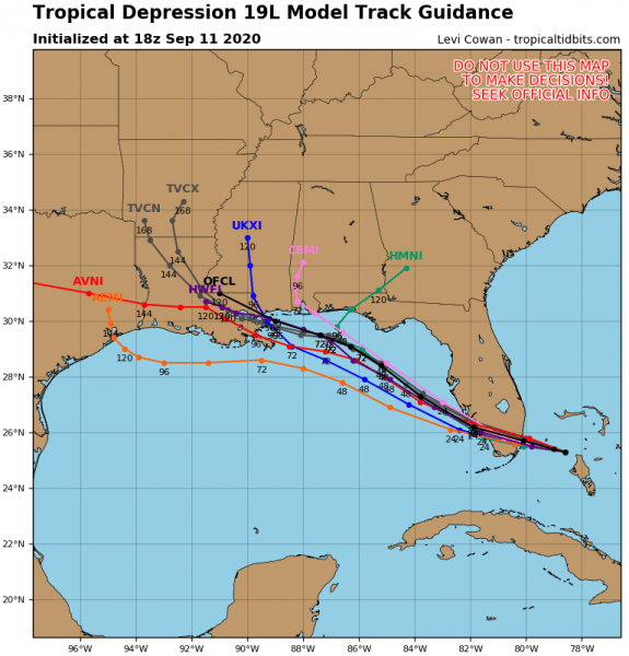
Once in the Gulf of Mexico strengthening will occur at a steady rate. As mentioned earlier Gulf of Mexico water temperatures are in the mid to upper 80s. There is minimal if any wind shear being indicated by weather models in the Eastern Gulf of Mexico and the system will have the aid of a developing upper high over it. All the ingredients are here for strengthening to a hurricane but the track is uncertain.
Hurricane model forecast tracks are taking aim for Louisiana for landfall sometime on Tuesday but the flow in the Gulf could take this further west under higher pressures across the Gulf States. The ridge of high pressure is not overly strong so this creates some variability in model tracks.
The track that is furthest to the south follows much like the NAM model which was among the first models showing this system developing a few days ago. We will be watching this closely over the weekend.
BE SURE TO DOWNLOAD THE FREE METEOROLOGIST JOE CIOFFI WEATHER APP &
ANGRY BEN’S FREE WEATHER APP “THE ANGRY WEATHERMAN!
MANY THANKS TO TROPICAL TIDBITS FOR THE USE OF MAPS
Please note that with regards to any severe weather, tropical storms, or hurricanes, should a storm be threatening, please consult your local National Weather Service office or your local government officials about what action you should be taking to protect life and property.


