Tropical Cyclone Potential Next 7 Days

Tropical Cyclone Potential Next 7 Days
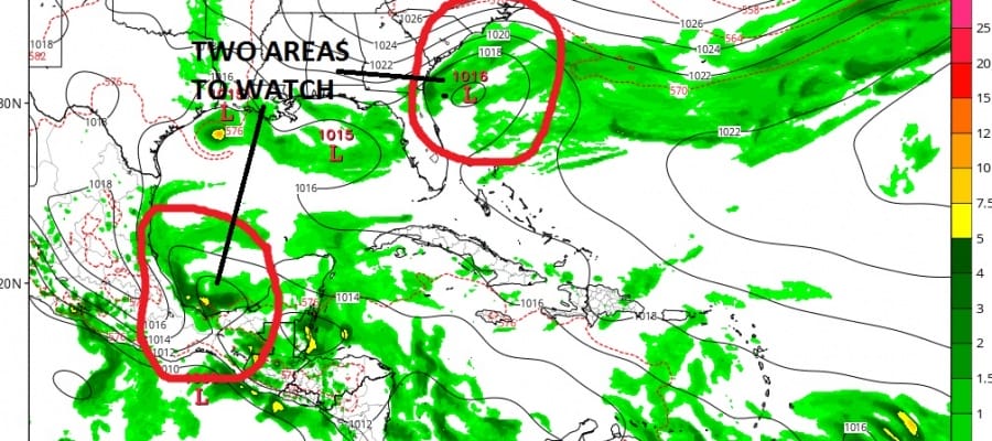
2 Possible Areas To Watch
Today’s view of the tropicsl remains very quiet and rather normal for mid June. The Gulf of Mexico is shown to be just about free of any clouds . This should be the case for the next couple of days. Now over the weekend and early next week, pressures are going to be low in the Southwest Gulf of Mexico and some models are forecasting low pressure to form there. More in this in just a bit.
Tropical Cyclone Potential Next 7 Days
Gulf of Mexico Satellite Loop

Western Atlantic Satellite Loop

On the wider Western Atlantic view there is a disturbance in the southern Caribbean that is moving westward. No development from this is forecast though some of this moisture may eventually find its way into the Northwest Caribbean and Southwest Gulf of Mexico late this week. The wider view of the Tropical Atlantic show that area to be quiet though there is a frontal boundary northeast of Puerto Rico. No development is expected from this as that area moves northeastward.

The two areas of interest pop up over the weekend. One is low pressure that moves off the Middle Atlantic Coast and drops southwestward to off the Southeast Coast. This is an upper air low that moves off the coast and gets suppressed to the south. Two things that stands against development here is the fact that the system is cold core in nature. The second is time. It would need to sit there for a few days in order to make a transition from a cold core to a warm core system and time might be working against this. The low is forecast to move westward and inland early next week.
Tropical Cyclone Potential Next 7 Days
GFS MODEL SUNDAY MORNING
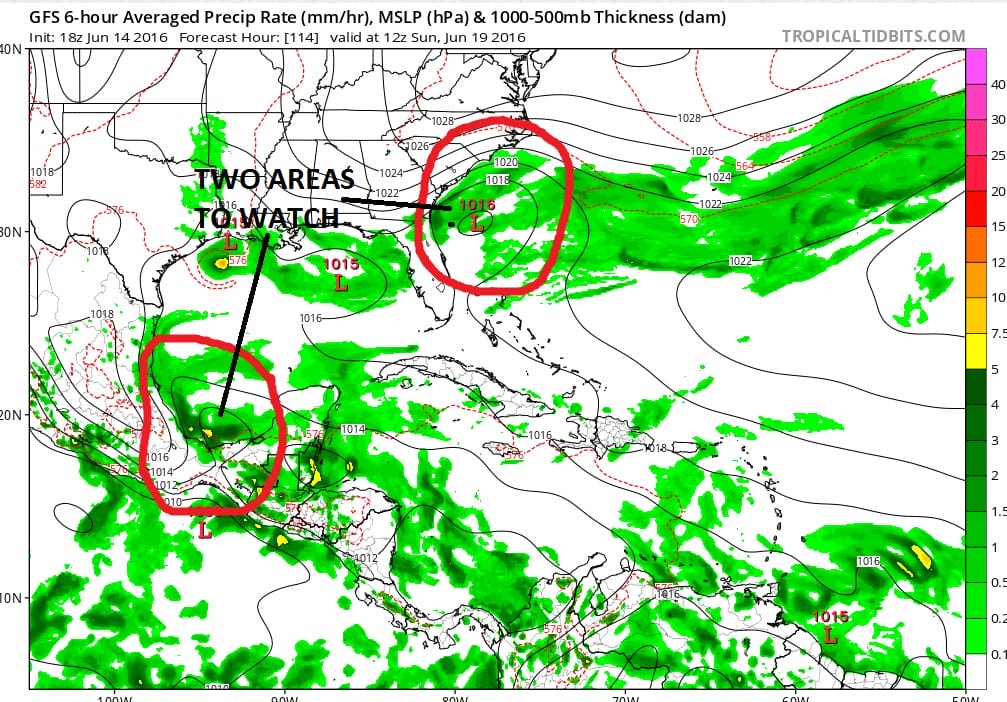
The second area is low pressure as mentioned early in the Southwest Gulf. Some models are developing in this and some aren’t. The GFS model has been going back and forth on this and I think this has a shot to develop into something early next week. We will continue to monitor this over the next several days.
JOESTRADAMUS HURRICANE SEASON GUEST FORECAST
FiOS1 News Weather Forecast For Long Island
FiOS1 News Weather Forecast For New Jersey
FiOS1 News Weather Forecast For Hudson Valley
NATIONAL WEATHER SERVICE SNOW FORECASTS
LATEST JOESTRADAMUS ON THE LONG RANGE
Weather App

Don’t be without Meteorologist Joe Cioffi’s weather app. It is really a meteorologist app because you get my forecasts and my analysis and not some automated computer generated forecast based on the GFS model. This is why your app forecast changes every 6 hours. It is model driven with no human input at all. It gives you an icon, a temperature and no insight whatsoever.
It is a complete weather app to suit your forecast needs. All the weather information you need is right on your phone. Android or I-phone, use it to keep track of all the latest weather information and forecasts. This weather app is also free of advertising so you don’t have to worry about security issues with your device. An accurate forecast and no worries that your device is being compromised.
Use it in conjunction with my website and my facebook and twitter and you have complete weather coverage of all the latest weather and the long range outlook. The website has been redone and upgraded. Its easy to use and everything is archived so you can see how well Joe does or doesn’t do when it comes to forecasts and outlooks.
Just click on the google play button or the apple store button on the sidebar for my app which is on My Weather Concierge. Download the app for free. Subscribe to my forecasts on an ad free environment for just 99 cents a month.
Get my forecasts in the palm of your hand for less than the cost of a cup of Joe!
![]()
![]()

MENTION JOE CIOFFI AND GET A 5% DISCOUNT