TROPICAL CYCLONE FORMATION POSSIBLE NEXT 5 DAYS
The National Hurricane Center has begun issuing tropical disturbance statements regarding the area of disturbed weather developing in the Southwest Atlantic East of the Bahamas. Weather models for days have been showing this and conditions are going to be somewhat favorable for some development through the holiday weekend.
TROPICAL CYCLONE FORMATION
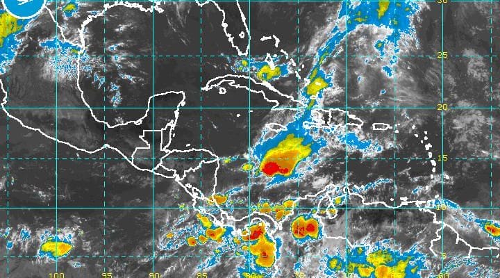
POSSIBLE SATELLITE LOOP

The satellite loop this morning shows disorganized weather east northeast of the Bahamas as part of an old front that is falling apart. What will be left will be an area of showers and thunderstorms and weak low pressure is forecast to develop and move westward. As we pointed out yesterday in our story about an early start to hurricane season, water temperatures right now are borderline. There will be a light wind shear environment developing over time which is a plus for organization.
TROPICAL CYCLONE FORMATION POSSIBLE
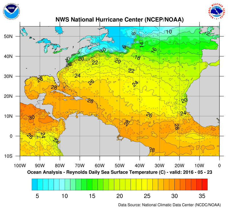
NATIONAL HURRICANE CENTER 5 DAY OUTLOOK

Water temperatures are not only borderline but they are actually now cooler than normal in the Southwest Atlantic for the first time in ages.
We will monitor this of course and given the time of year, conditions have to really line up for tropical storm formation. It is not impossible but the atmosphere will have a lot of work to do.
FiOS1 News Weather Forecast For Long Island
FiOS1 News Weather Forecast For New Jersey
FiOS1 News Weather Forecast For Hudson Valley
NATIONAL WEATHER SERVICE SNOW FORECASTS
LATEST JOESTRADAMUS ON THE LONG RANGE

NOMINATED FOR AN APPY AWARD FOR BEST WEATHER APP!!
Weather App

Don’t be without Meteorologist Joe Cioffi’s weather app. It is really a meteorologist app because you get my forecasts and my analysis and not some automated computer generated forecast based on the GFS model. This is why your app forecast changes every 6 hours. It is model driven with no human input at all. It gives you an icon, a temperature and no insight whatsoever.
It is a complete weather app to suit your forecast needs. All the weather information you need is right on your phone. Android or I-phone, use it to keep track of all the latest weather information and forecasts. This weather app is also free of advertising so you don’t have to worry about security issues with your device. An accurate forecast and no worries that your device is being compromised.
Use it in conjunction with my website and my facebook and twitter and you have complete weather coverage of all the latest weather and the long range outlook. The website has been redone and upgraded. Its easy to use and everything is archived so you can see how well Joe does or doesn’t do when it comes to forecasts and outlooks.
Just click on the google play button or the apple store button on the sidebar for my app which is on My Weather Concierge. Download the app for free. Subscribe to my forecasts on an ad free environment for just 99 cents a month.
Get my forecasts in the palm of your hand for less than the cost of a cup of Joe!
![]()
