Tornado Watch Posted Western New Jersey Pennsylvania
Flash Flood Watch Most of New Jersey & Pennsylvania
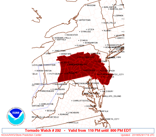
The NWS Storm Prediction Center has issued a
* Tornado Watch for portions of
Extreme northern Delaware
Extreme northeastern Maryland
Western and southern New Jersey
Much of central and eastern Pennsylvania
Coastal Waters
* Effective this Wednesday afternoon and evening from 110 PM
until 800 PM EDT.
* Primary threats include…
A couple tornadoes possible
Scattered large hail likely with isolated very large hail events
to 2 inches in diameter possible
Scattered damaging wind gusts to 70 mph likely
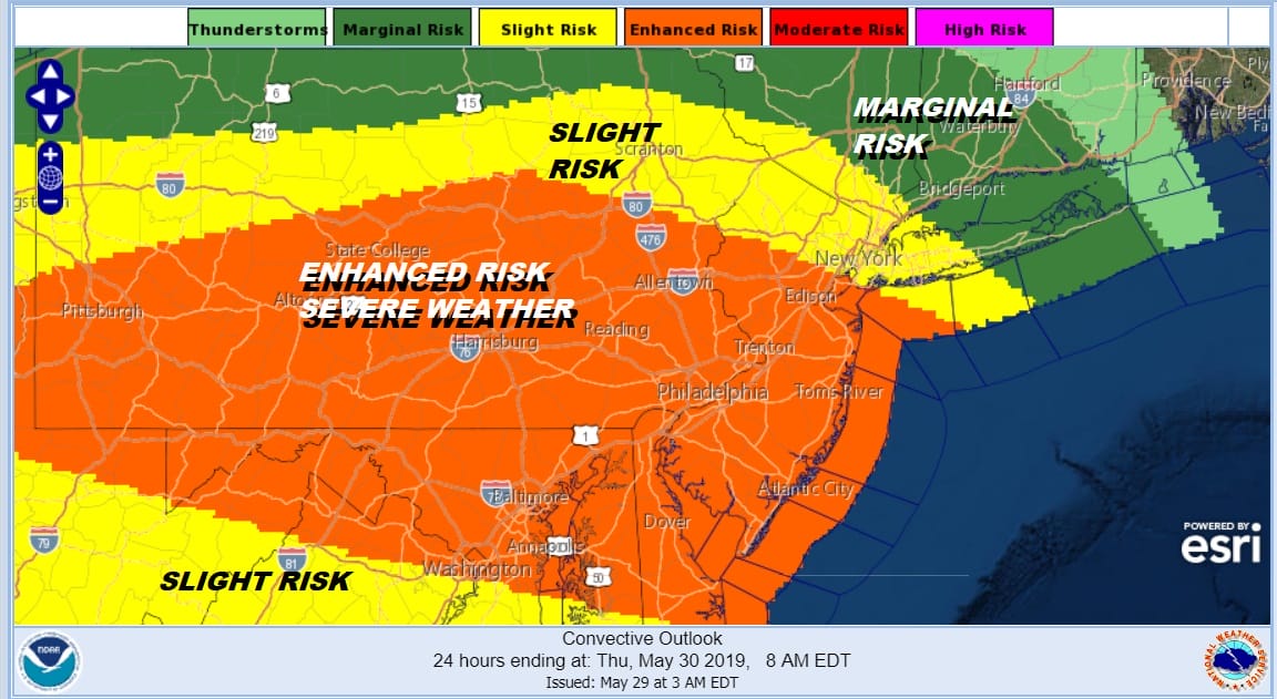
SUMMARY…Scattered supercell development is expected this afternoon
across central/eastern Pennsylvania and the storms will move
east-southeastward into New Jersey this afternoon/evening. Large
hail and damaging winds are likely with these storms, and a couple
of tornadoes will also be possible with storm and boundary
interactions.
The tornado watch area is approximately along and 60 statute miles
north and south of a line from 40 miles northwest of Altoona PA to
10 miles east northeast of Trenton NJ. For a complete depiction of
the watch see the associated watch outline update (WOUS64 KWNS
WOU2).
PRECAUTIONARY/PREPAREDNESS ACTIONS…
REMEMBER…A Tornado Watch means conditions are favorable for
tornadoes and severe thunderstorms in and close to the watch
area. Persons in these areas should be on the lookout for
threatening weather conditions and listen for later statements
and possible warnings.
We have a tornado watch posted for the same area that we did yesterday though the Storm Prediction Center did add the South Jersey counties this time around. They cover the counties in Western New Jersey from Warren & Hunterdon Counties southward and westward across most of Pennsylvania with the exception of the extreme north. Bear in mind that last night’s tornadoes occurred in areas inside as well as just outside the watch area so if you are in the Eastern Counties of New Jersey not under the watch I would pay close attention to the weather this afternoon.
SATELLITE

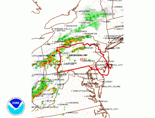
The satellite picture this afternoon looks much the same like yesterday. A warm front lies just south of New York City. Daytime heating is sending temperatures in the 70s and 80s south of that warm front while it is in the 60s to the north. Regional & local radars are picking up on the activity developing to the west in Pennsylvania. The thunderstorms will be coming in a bit earlier than yesterday and could impact the evening commute so allow yourself some extra time.
REGIONAL RADAR

LOCAL RADAR NEW YORK CITY

LOCAL RADAR PHILADELPHIA


NEW JERSEY COUNTIES INCLUDED ARE
ATLANTIC BURLINGTON CAMDEN
CAPE MAY CUMBERLAND GLOUCESTER
HUNTERDON MERCER SALEM
WARREN
Thunderstorms will be moving through this evening and into the first part of tonight. They will also impact areas to the east of the watch area as well out to Long Island, Southern New England, the Hudson Valley, and Eastern New Jersey. Flash Flood Watch is also posted for much of New Jersey & Eastern Pennsylvania. A second day of potential heavy rains means the threshold for flooding is low. It won’t take much to cause flooding from heavy rains.
Keep your eyes on the radar this evening. Once the thunderstorms move out weather conditions will improve tonight. Then another and final cold front approaches on Thursday with another round of late day thunderstorms until better weather arrives on Friday.
MANY THANKS TO TROPICAL TIDBITS FOR THE USE OF MAPS
Please note that with regards to any tropical storms or hurricanes, should a storm be threatening, please consult your local National Weather Service office or your local government officials about what action you should be taking to protect life and property.