
Thunderstorms Into This Evening Some Severe Then Heat Humidity Arrive

Weather in 5/Joe & Joe Weather Show Latest Podcast
Thunderstorms Into This Evening Some Severe Then Heat Humidity Arrive
The Storm Prediction Center has issued a Severe Thunderstorm Watch from Southwest Connecticut to the Hudson Valley, Western Long Island to NYC, all of New Jersey (except Sussex County) and a small portion of Southeast Pennsylvania and this includes the surrounding coastal waters.

The upper trough that is moving east is creating a very unstable atmosphere and we are seeing strong to severe thunderstorms coming out of Pennsylvania and moving eastward. There is no ocean wind to weaken these storms so they will hold together as they track eastward.

The radar shortly before 3pm showed three active severe thunderstorm warning in Eastern Pennsylvania and loops show these storms heading into New Jersey and they should eventually reach the coast this evening. Look for heavy rains and strong gusty winds from these storms. Once the upper trough moves offshore weather conditions will improve tonight as skies clear. Morning lows will be in the low to mid 60s.
SATELLITE

On to the weekend where a hot humid stretch of weather begins and lasts through next Wednesday.There are no changes in the outlook. Places away from the coast will be stringing together 4 to 6 days of 90 degree plus highs. We are looking at sunshine for Saturday, moderate levels of humidity, and highs reaching 85 to near 90 degrees in most places. Look for cooler temperatures at the shore where local sea breezes will take hold.
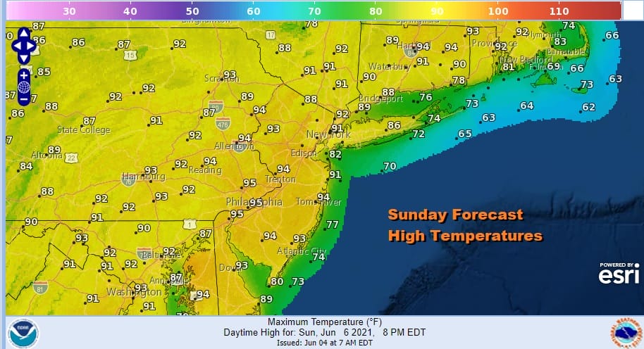
An upper ridge builds northward along the East Coast this weekend and holds into early next week so with sunshine Sunday, nothing should stop temperatures from reaching 90 to 95 across inland areas with 80s to near 90 in Southern New England and Long Island.

We can pretty much wash rinse repeat this forecast through Tuesday as the upper ridge holds. Winds will have a westerly component rather than a southerly component and that should keep sea breezes confined to the immediate coast. As far as thunderstorms are concerned, the upper ridge will suppress downpour or thunderstorm formation through Tuesday other than perhaps some isolated cells that could form. Even if they do, they don’t last and you get caught in one, just wait a few minutes. The next cold front will drop southward from Eastern Canada and pass through late Wednesday with a shower or thunderstorm. It should turn a little cooler for Thursday and Friday of next week.

BE SURE TO DOWNLOAD THE FREE METEOROLOGIST JOE CIOFFI WEATHER APP &
ANGRY BEN’S FREE WEATHER APP “THE ANGRY WEATHERMAN!
MANY THANKS TO TROPICAL TIDBITS FOR THE USE OF MAPS
Please note that with regards to any severe weather, tropical storms, or hurricanes, should a storm be threatening, please consult your local National Weather Service office or your local government officials about what action you should be taking to protect life and property.


