Thunderstorm Scattered This Evening Could Be Severe
Thunderstorm Scattered This Evening Could Be Severe
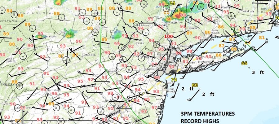
We are seeing some thunderstorms popping up on the radars this evening and we have seen on Severe Thunderstorm Warning for Dutchess County this afternoon and now we have one for Eastern Putnum and North Central Fairfield County in Connecticut
The National Weather Service in Upton NY has issued a
* Severe Thunderstorm Warning for…
North central Fairfield County in southern Connecticut…
Eastern Putnam County in southeastern New York…
* Until 400 PM EDT
* At 316 PM EDT, a severe thunderstorm was located near Pawling,
moving southeast at 25 mph.
HAZARD…60 mph wind gusts and quarter size hail.
SOURCE…Radar indicated.
IMPACT…Hail damage to vehicles is expected. Expect wind damage
to roofs, siding, and trees.
* This severe thunderstorm will be near,
Sherman around 335 PM EDT.
New Fairfield around 340 PM EDT.
Danbury and Brookfield around 355 PM EDT.
Newtown and Bethel around 400 PM EDT.
SATELLITE LOOP

REGIONAL RADAR

LOCAL RADAR NEW YORK CITY

LOCAL RADAR PHILADELPHIA


The cold front that will break this heat wave is approaching however we don’t see widespread thunderstorm activity this evening. However there will be some scattered strong thunderstorms that could develop as the Storm Prediction Center does have us in a marginal risk for severe weather this evening.
 GET JOE A CIGAR IF YOU LIKE

FiOS1 News Weather Forecast For Long Island
FiOS1 News Weather Forecast For New Jersey
FiOS1 News Weather Forecast For Hudson Valley
NATIONAL WEATHER SERVICE SNOW FORECASTS
LATEST JOESTRADAMUS ON THE LONG RANGE