Temperatures Warming Up Chance For Showers Thursday Into Friday

Weather in 5/Joe & Joe Weather Show Latest Podcast
Temperatures Warming Up Chance For Showers Thursday Into Friday
Some areas started out with clouds this morning but on the whole it is a nice day of sunshine from Eastern Pennsylvania to Southern New England. Checking on the satellite loops and pictures today, except for that stick of clouds in Upstate NY that extends into parts of Central New England, much of the east is sitting in sunshine. Radars are nice and quiet and are not an issue through Wednesday.
SATELLITE

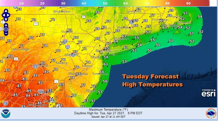
Temperatures this afternoon are going to vary widely. For example across Maryland into Virginia many areas will break 80 degrees this afternoon. However north and east of NYC into Southern New England the Hudson Valley mostly 60s should be the highs.
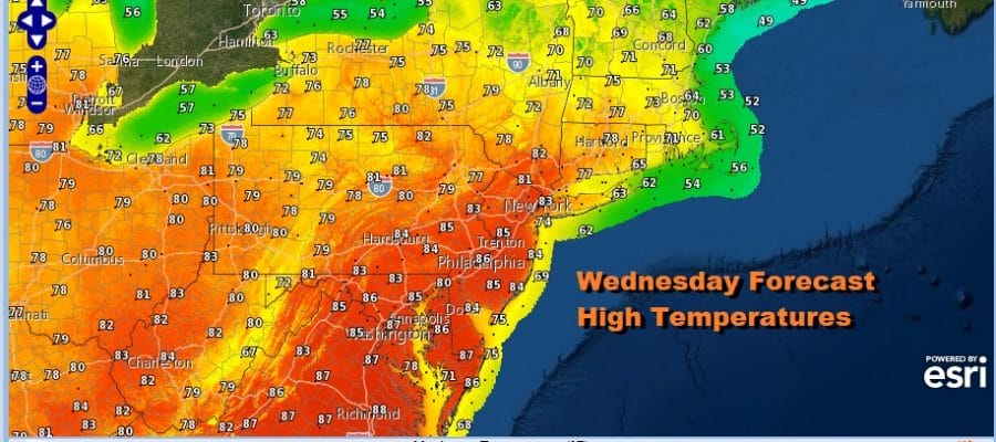
Temperatures will not drop much tonight in the upper 40s to mid 50s under mainly clear skies, and that sets us up with a great launching pad for Wednesday. We are on course for sunshine taking highs into the 80s away from the coast. Cooler temperatures will be over south and east facing shorelines. Wednesday will be the warmest day of the week.

Wednesday night a cold front will approach and move through. I will throw in the mention of a shower or thunderstorm (widely scattered) as the front passes and stalls virtually right over us on Thursday. This makes the Thursday forecast a bit of a challenge because location will be a big deal here.

Thursday will be a day of clouds and sun. More sun if you head south. More clouds around and north of the frontal boundary. This is why highs north of NYC will be in the upper 60s and lower 70s while head down to Southern New Jersey, Southeastern Pennsylvania and points south it will be in the 80s.
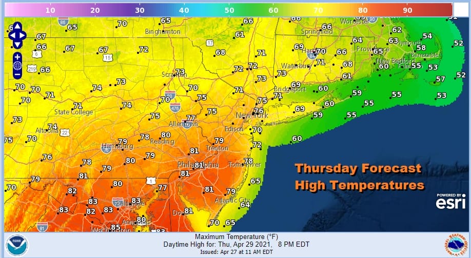
With the frontal boundary over head we will watch for some scattered showers or a thunderstorm in the afternoon and evening. Friday it appears the front will start sinking southward and we could see improving and cooler weather conditions with clouds giving way to some sunshine. Highs will be in the upper 60s and lower 70s. The profile for Friday could mean no showers or thunderstorms of consequence. Only the GFS holds on to the idea of showers and thunderstorms for Friday. The weekend is looking okay though cool on Saturday with some sunshine. Highs will be in the upper 50s and lower 60s. Sunday some sunshine should take highs through the 60s to near 70. Overall it should be a good weekend.

BE SURE TO DOWNLOAD THE FREE METEOROLOGIST JOE CIOFFI WEATHER APP &
ANGRY BEN’S FREE WEATHER APP “THE ANGRY WEATHERMAN!
MANY THANKS TO TROPICAL TIDBITS FOR THE USE OF MAPS
Please note that with regards to any severe weather, tropical storms, or hurricanes, should a storm be threatening, please consult your local National Weather Service office or your local government officials about what action you should be taking to protect life and property.


