Sunshine Warmer Temperatures Into A No Rain Weekend!
No Issues For NYC, Hudson Valley, New Jersey, Long Island

Sunshine Warmer Temperatures Into A No Rain Weekend!
No Issues For NYC, Hudson Valley, New Jersey, Long Island
We have not only arrived at the doorstep of the weekend but it will be the first time in nine weekend that we have no rain in the forecast for either weekend day. The core of the cold air mass over the Eastern US is moving offshore today as high pressure exits to the east. A west wind will allow temperatures to bounce higher and well off the morning lows which once again were in the 20s and 30s. Skies today should be no worse than partly sunny across Eastern Pennsylvania to Southern New England and temperatures this afternoon will top out in the 50s area wide. Radars are nice and quiet and they will not be an issue into Monday.
SATELLITE WITH LIGHTNING STRIKES

WEATHER RADAR

As the days warm up, the nights will be warming up as well. Skies will be clear tonight with lows by Saturday morning in the upper 30s to mid 40s in most places. Some cold spots could see lows below freezing but they will be the exception rather than the rule.

As the atmosphere warms up on a west wind we may see some patchy clouds around for Saturday as well as for Sunday. However this should be no big deal and skies should be no worse than partly sunny for both weekend days. We will warm up but only back to where we should be for this time of year as the ridge in the Eastern US is rather flat unlike last week when we saw record highs.

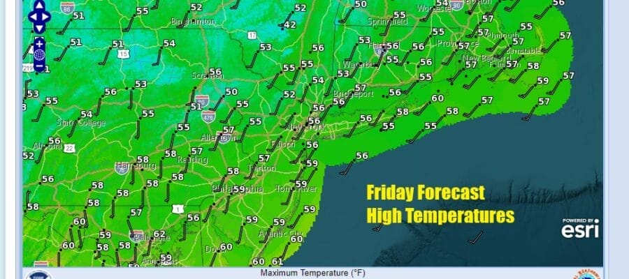
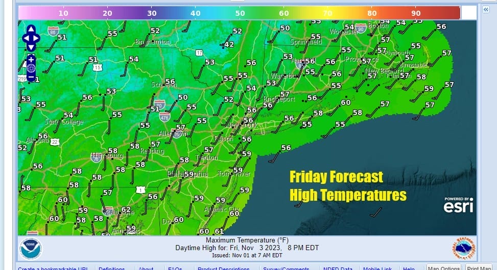
Most highs Saturday will be in the upper 50s and lower 60s. Some wrm spots in South Jersey could push it up to 64 or 65. The same holds for Sunday as we will have no worse than partly sunny skies. Afternoon highs again will be in the upper 50s and lower 60 with a few warm spots pushing it up a little higher. No rain is forecast for either weekend day so take your pick as both will be equally as good.
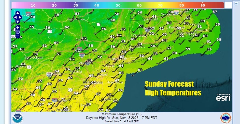
Next week we see a couple of weak weather systems moving along in the flow. No major storms are on the horizon but we do have a cold front to deal with on Tuesday. Low pressure will be moving across the Great Lakes to Northern New England. The traling front doesn’t have much moisture with it, it may have enougn to produce some showers when it moves through later Monday night into Tuesday. This leaves much if not all of Monday dry with some sunsnine and clouds with highs in the 60s. Later Monday night and Tuesday we are likely to see some showers followed by somewhat colder air coming in behind it. It will not be as cold as this current air mass it will take temperatures lower for the rest of the week. A second system may be in the cards for Thursday with a chilly rain likely as low pressure moves across the Ohio Valley and redevelops nearby offshore. This system might bring some snow to areas in Upstate NY and interior New England but it is a long way off and it doesn’t appear to be anything to be concerned with.
BE SURE TO DOWNLOAD THE FREE METEOROLOGIST JOE CIOFFI WEATHER APP &
ANGRY BEN’S FREE WEATHER APP “THE ANGRY WEATHERMAN!
MANY THANKS TO TROPICAL TIDBITS FOR THE USE OF MAPS
Please note that with regards to any severe weather, tropical storms, or hurricanes, should a storm be threatening, please consult your local National Weather Service office or your local government officials about what action you should be taking to protect life and property.
(Amazon is an affilate of Meteorologist Joe Cioffi & earns commissions on sales.)


