Sunshine Through A Smokey Haze As Temperatures Warm
Showers Thunderstorms Monday

Sunshine Through A Smokey Haze As Temperatures Warm
Showers Thunderstorms Monday
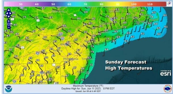
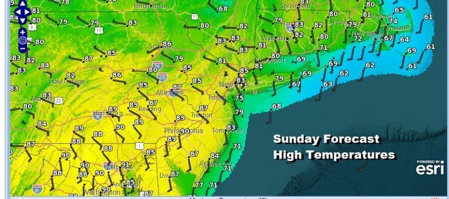
Today will be a very warm day across Eastern Pennsylvania to Southern New England. Winds both at thes urface and aloft are turning south which will allow temperatures to warm up nicely inland. Dew points are going to come up a bit today as they reach the mid to upper 50s but it will still be reasonably comfortable and I really wouldn’t describe this as a humid day by any means. Highs will reach the mid to upper 80s inland. An odd hot spot or two could approach 90. Meanwhile along the coast it will be in the cooler 60s and 70s especially along south and east facing shorelines. We will mention a teeny tiny chance for an isolated pop up shower or thunderstorm inland but the chances are very low and the vast majority of you won’t see a thing.
SATELLITE

WEATHER RADAR

As far as smoke is concerned, we will likely see some hazy conditions today and Southeastern Pennsylvania is under an air quality alert though no other areas have been put into an air quality alert as of 7am. This could change during the day so be aware of what is happening to avoid being in an unhealthy situation. Milky white areas are showing up on satellite loops which are higher than yesterday but not nearly as high as they were back last Wednesday.
Most lows tonight will be in the low to mid 60s with just some patchy clouds which takes us into Monday. Humidity levels will be higher as dew points climb into the 60s and we have an approaching cold front. This should set off showers and thunderstorms from west to east during the day though the greatest risk will be during the afternoon and evening hours.

It will be a warm and rather humid Monday ahead of the front but we probably won’t see much in terms of susnhine. That will keep temperatures in check with most highs in the mid to upper 70s. The south wind will keep it cooler along south and east facing shorelines. This may temper thunderstorms a bit as they head eastward.
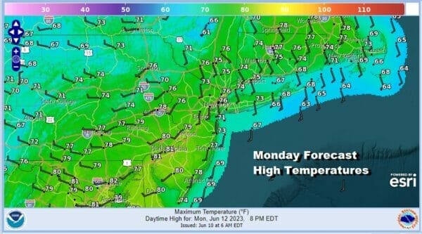
As for right now the Storm Prediction Center has a marginal risk for isolated severe thunderstorms from Delaware to Southern New Jersey Monday afternoon and evening but I think there is a chance we could see this area extended further northward come Monday, especially if it looks as if we could get some sunshine and daytime heating to throw into the mix. As for rainfall amounts it appears that areas inland will see more rain than those to the east. Half an inch to an inch seems fair with locally higher amounts in thunderstorms

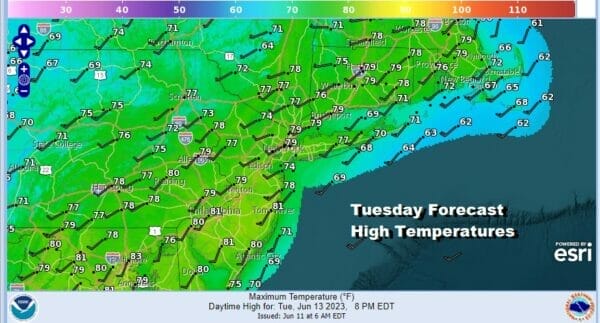
The week ahead will be about a series of cold fronts moving through from west to east. We will also see temperatures day to day be on the cooler side of average but not by much. Tuesday we look for a mix of sun and clouds thanks to a slightly cold and unstable atmosphere aloft. Highs will be in the mid 70s to around 80.
We will continue the same idea for Wednesday temperature wise but we do have another cold front and upper trough coming through. That opens the door for the chance for showers or a thunderstorm in the afternoon and evening. Highs again will be in the mid 70s to around 80 degrees.

A brief break comes Thursday and we will likely warm up into the 80s in most places with sunshine. Another front will arrive Thursday night and there is a chance for showers or thunderstorm overnight into Friday morning. Then weather conditions should improve with some developing sunshine Friday, though there still could be the odd shower or thunderstorm in the afternoon and evening. Highs Friday will be in the upper 70s and lower 80s
BE SURE TO DOWNLOAD THE FREE METEOROLOGIST JOE CIOFFI WEATHER APP &
ANGRY BEN’S FREE WEATHER APP “THE ANGRY WEATHERMAN!
MANY THANKS TO TROPICAL TIDBITS FOR THE USE OF MAPS
Please note that with regards to any severe weather, tropical storms, or hurricanes, should a storm be threatening, please consult your local National Weather Service office or your local government officials about what action you should be taking to protect life and property.
(Amazon is an affilate of Meteorologist Joe Cioffi & earns commissions on sales.)


