
Sunday Sunshine Very Warm Severe Weather Risks Monday Autumn Arrives Friday
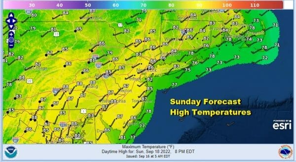
Here we are in the second half of the last weekend of the summer season and it will go out in the way that most weekends did this summer. It will be very warm, technically it will be more humid today but not unreasonable. We have sunny skies for much of the day and nothing more than a few passing clouds. Most highs today will be in the mid to upper 80s though it will be a little cooler along the shore with local sea breezes developing. No rain is forecast. Tonight will be warm with most lows in the 60s, 50s in cool spots with clear skies though some pathcy low clouds and fog could develop.

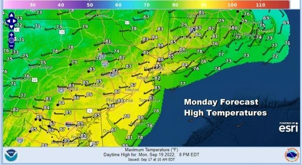
Monday brings partly sunny skies very warm and humid conditions with highs in the mid to upper 80s. We do have a cold front that will be approaching and that could set off some scattered showers and thunderstorms late in the day. The Storm Prediction Center continues to indicate a marginal risk for severe weather across Pennsylvania into Northern New Jersey and the Hudson Valley. Marginal risk means isolated severe thunderstorms.
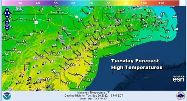
Once the front passes it will turn a little cooler and less humid for Tuesday with sunshine coming back. Highs will be in the upper 70s and lower 80s. Then it is back to a southwest flow for Wednesday when it will be very warm and more humid. We will high sunshine taking highs Wednesday to the mid and upper 80s. Some warm spots might even tough 90 degrees.

It looks like the timing for another cold front will be Wednesday night into early Thursday morning. This front will bring in the beginnings of a very cool dry air mass for Thursday and into the weekend. This will definitely be an Autumn air mass with the new season arriving Friday afternoon. Thursday clouds will give way to some sun with a gusty wind. Highs will be in the mid 70s to lower 80s.
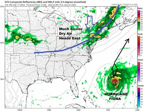
The front will not only bring the coolest air mass since back last May, but it will sweep what will be Hurricane Fiona and keep it offshore though it could come very close to Bermuda. Fiona will merge with the deep trough in Eastern Canada and we will see very cool temperatures Thursday into Saturday afternoon. We are looking at high temperatures not getting out of the 60s for Friday and possibly Saturday as well. Nighttime lows will be in the 40s to lower 50s.
BE SURE TO DOWNLOAD THE FREE METEOROLOGIST JOE CIOFFI WEATHER APP &
ANGRY BEN’S FREE WEATHER APP “THE ANGRY WEATHERMAN!
MANY THANKS TO TROPICAL TIDBITS & F5 WEATHER FOR THE USE OF MAPS
Please note that with regards to any severe weather, tropical storms, or hurricanes, should a storm be threatening, please consult your local National Weather Service office or your local government officials about what action you should be taking to protect life and property.


