
Nice Weekend, Severe Weather Risk Monday, Late Next Week Autumn Arrives

The weekend is underway and we have a lovely start. There are some patchy clouds around in a few places but they won’t last long and skies should be partly to mostly sunny for the rest of this Saturday. Some areas are experiencing some haze and that is due to smoke from the Western US wildfires that are being brought eastward by upper level west winds. Highs this afternoon from NYC east will be in the mid 70s while most other areas will see highs in the upper 70s to lower 80s. No rain is forecast for today nor is any rain forecast for Sunday. Humidity levels today are rising but remain reasonable.
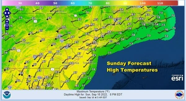
Sunday begins a stretch of very warm and more humid weather that will last into Thursday of this coming week. Starting with tonight when it won’t be as cool as past nights. Lows will be in the upper 50s to mid 60s. Sunday will be very warm and more humid with sunshine taking highs to the mid to upper 80s in most places. Temperatures both today and Sunday will be cooler at the shore.
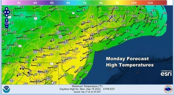
Monday will be very warm and humid with sunshine into the afternoon but we do have a cold front that will be approaching from the Great Lakes. This will likely produce a few scattered showers and thunderstorms late in the day as the front passes. There is a risk for some of the thunderstorms to develop into isolated severe cells. The Storm Prediction Center is indicating a marginal risk for isolated severe thunderstorms Monday.

Tuesday we will see the humidity break as dew points drop and we will have some sunshine returning. Highs will be in the upper 70s and lower 80s. Wednesday will be another day with some sunshine with highs reaching the mid to upper 80s. Then a stronger cold front arrives Thursday.
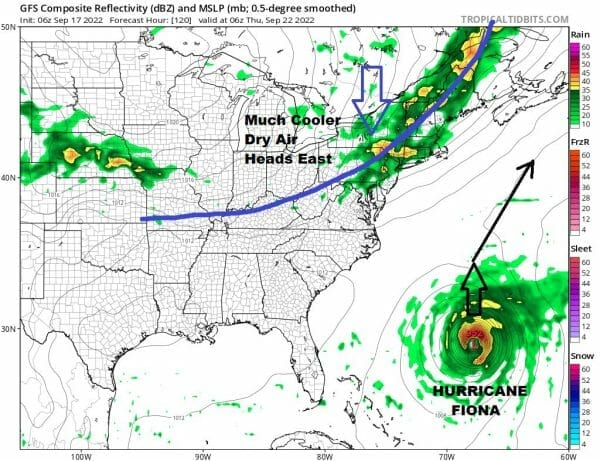
Tropical Storm Fiona is nearing Puerto Rico where Hurricane Warnings are posted. We also have Tropical Storm Warnings for the northern Leeward and Virgin Islands as well as the east coast of the Domincan Republic. Late this week we have a deep upper trough dropping into Southeastern Canada. It is represented by a strong cold front moving into the Northeast US. That front will bring the chance for showers and thunderstorms Thursday but it will also do 2 other things. One is that it will act like a broom and once offshore it will sweep Fiona to the Northeast. It will also strengthen the upper trough and create a strong northwest flow from Canada. This will usher in a rather cool and very dry air mass for Friday and next weekend just in time with the arrival of Autumn! Other than the two fronts and the chance for showers and storms with their passage, little to no rain is forecast for the next 7 days or longer.
BE SURE TO DOWNLOAD THE FREE METEOROLOGIST JOE CIOFFI WEATHER APP &
ANGRY BEN’S FREEr t WEATHER APP “THE ANGRY WEATHERMAN!
MANY THANKS TO TROPICAL TIDBITS & F5 WEATHER FOR THE USE OF MAPS
Please note that with regards to any severe weather, tropical storms, or hurricanes, should a storm be threatening, please consult your local National Weather Service office or your local government officials about what action you should be taking to protect life and property.


