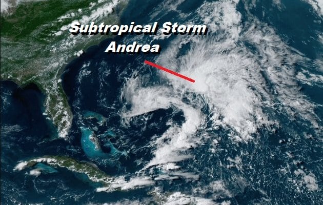
Subtropical Storm Andrea Forms in the Southwest Atlantic
Disturbed weather that has been sitting between the Bahamas and Bermuda has become better organized and for the 5th year in a row we are seeing a tropical or subtropical storm before the official start of hurricane season which is June 1st. Andrea can be seen and the satellite picture below as that bright white ball of convection stands out. An Air Force Recon found 40 mph winds and a well defined low level circulation center.
SATELLITE
Early storms usually have very short shelf lifes and this one will be gone in a couple of days. The cold front moving offshore tonight over us with low pressure moving across New England will eventually absorb this system, probably sometime on Wednesday. In the meantime the storm is southwest of Bermuda and should pass south of the island based on the forecast track and what is going on in the upper air.
Subtropical Storm Andrea
Subtropical Storm Andrea Special Advisory Number 1
NWS National Hurricane Center Miami FL AL012019
630 PM AST Mon May 20 2019
…SUBTROPICAL STORM ANDREA FORMS OVER THE WESTERN ATLANTIC…
SUMMARY OF 630 PM AST…2230 UTC…INFORMATION
———————————————-
LOCATION…28.8N 68.7W
ABOUT 335 MI…540 KM SW OF BERMUDA
MAXIMUM SUSTAINED WINDS…40 MPH…65 KM/H
PRESENT MOVEMENT…N OR 350 DEGREES AT 14 MPH…22 KM/H
MINIMUM CENTRAL PRESSURE…1006 MB…29.71 INCHES
WATCHES AND WARNINGS
——————–
There are no coastal watches or warnings in effect. Interests in
Bermuda should monitor the progress of this system.
DISCUSSION AND OUTLOOK
———————-
At 630 PM AST (2230 UTC), the center of Subtropical Storm Andrea was
located near latitude 28.8 North, longitude 68.7 West. The storm is
moving toward the north near 14 mph (22 km/h). A decrease in
forward speed and a turn to the northeast is expected on Tuesday,
followed by an eastward motion by Tuesday night. On the forecast
track, the center of Andrea is expected to remain southwest or
south of Bermuda during the next day or two.
Data from an Air Force Reserve Hurricane Hunter plane indicate that
the maximum sustained winds are near 40 mph (65 km/h) with higher
gusts. Slight strengthening is possible overnight. Weakening should
begin late Tuesday, and Andrea is expected to dissipate on
Wednesday.
Winds of 40 mph extend outward up to 70 miles (110 km) northeast of
the center.
The Air Force Hurricane Hunters measured a minimum central pressure
of 1006 mb (29.71 inches).
HAZARDS AFFECTING LAND
———————-
None
MANY THANKS TO TROPICAL TIDBITS FOR THE USE OF MAPS
Please note that with regards to any tropical storms or hurricanes, should a storm be threatening, please consult your local National Weather Service office or your local government officials about what action you should be taking to protect life and property.


