Stuck Between Two Systems But Mostly Dry Through Tuesday
Tropical Storm Form Gulf Of Mexico Next Week

Stuck Between Two Systems But Mostly Dry Through Tuesday
Tropical Storm Form Gulf Of Mexico Next Week
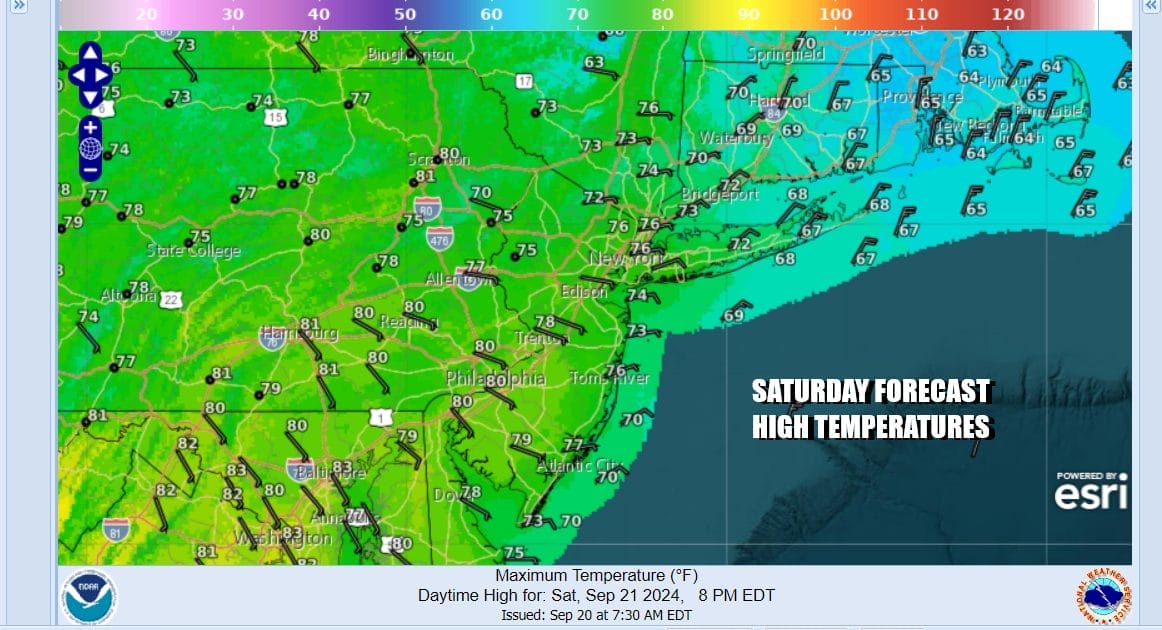
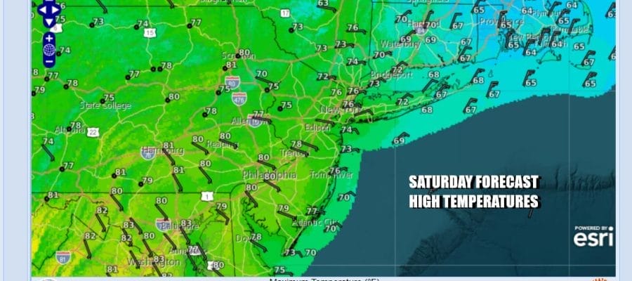
We are mostly in the same place we have been the last couple of days. Rain continues today over Southeastern New England with the back edge of that rain reaching as far west as Eastern Long Island and Connecticut. To the west we have an upper trough that is dropping southward from Eastern Canada and forecast to continue southward with some showers and a chance for an isolated severe thunderstorm from Pennsylvania to the Delmarva Peninsula. In that zone in between from New Jersey to Central Connecticut and Central Long Island we will see a cloudy to partly sunny day and no rain. Temperatures today will top out mostly in the 70s. The winds remain onshore and that means that for the immediate coast it will be in the cooler 60s and we will also continue to see minor to moderate coastal flooding at high tides. Coastal flood advisories and warnings continue for shore areas from Eastern New England south to Southeastern Virginia.
SATELLITE WITH LIGHTNING STRIKES

WEATHER RADAR

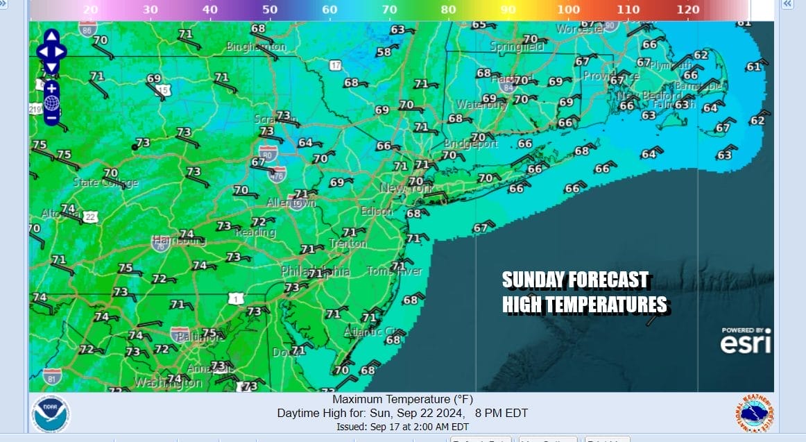
Tonight will be cloudy with showers to our west and south and rain to the east but the coastal low will start to move south in conjunction with that western upper trough. Then another dome of high pressure will build southwestward from Atlantic Canada and Northern New England that that means that the onshore flow continues into early next week. The air is drier so dew points will be dropping Sunday and Monday.

Sunday may start off with leftover clouds but then we should go partly to mostly sunny as the day wears on. Temperatures Sunday will likely be a little lower as that new high builds in and cooler air funnels southward from the northeast. The onshore flow continues with high temperatures Sunday afternoon reaching into the lower 70s inland but 60s will be likely coast.
Monday looks to be a dry day with sunshine for much of the day. The pattern next week changes as the block breaks down and this allows weather systems to move along from west to east once again. Also note that next week we will likely see a tropical storm develop in the Gulf of Mexico and most models strengthen this to a hurricane. We mention this because questions will being to come up regarding whether any of the rain from this system eventually heads up through the Eastern US.
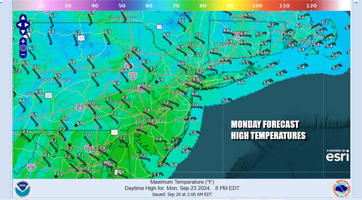
Monday highs will be in the upper 60s and lower 70s. Tuesday we see a warm front approaching and there could be some showers late Monday night into early Tuesday. A better chance for showers is likely for Wednesday as a cold front approaches. We will watch to see if that front passes or stalls as that will be part of the equation with any tropical system for the Eastern US.
BE SURE TO DOWNLOAD THE FREE METEOROLOGIST JOE CIOFFI WEATHER APP &
ANGRY BEN’S FREE WEATHER APP “THE ANGRY WEATHERMAN!
MANY THANKS TO TROPICAL TIDBITS FOR THE USE OF MAPS
Please note that with regards to any severe weather, tropical storms, or hurricanes, should a storm be threatening, please consult your local National Weather Service office or your local government officials about what action you should be taking to protect life and property.
(Amazon is an affilate of Meteorologist Joe Cioffi & earns commissions on sales.)


