
Strong Winds Continue Gusting to 40 MPH
Warmer Temps Late Week Into Saturday

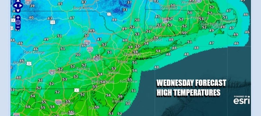
We have another round of strong gusty winds to get through. An upper trough moving across the Great Lakes and through the Northeast is bringing bands of clouds today but there will be some sunshine in the mix. Temperatures however will be taking a step backwards today with most highs in the low to mid 50s. Throw in winds of 20 to 30 mph with higher gusts and it will feel about 10 degrees colder. We still see some patchy light rain showers on the Northeast regional radar and we can’t rule out the chance for a light rain shower or two.
SATELLITE WITH LIGHTNING STRIKES

WEATHER RADAR

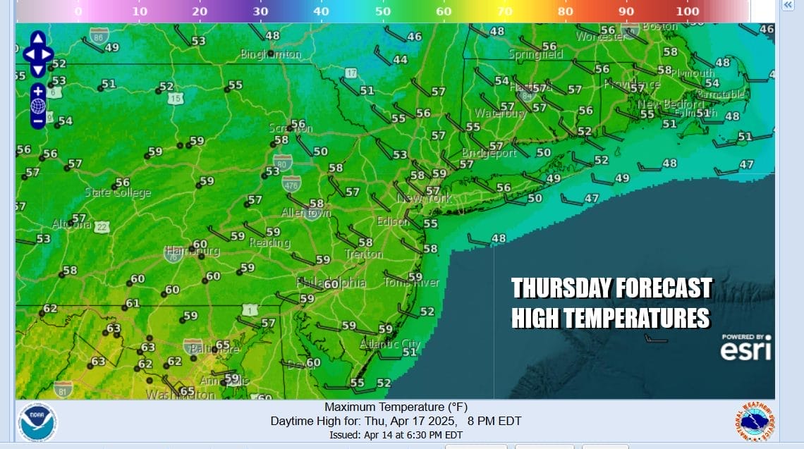
Skies should finally clear out tonight as the upper trough moves eastward and high pressure starts to build in. Winds should start to ease somewhat though they will still be on the breezy side. Lows Thursday morning will be in the 30s except near 40 degrees in some of the warmer urban locations. We should see less wind and some sunshine for Thursday and should allow temperatures to risk through the 50s to near 60 degrees.
High pressure moves off the Mid Atlantic coast and strengthens offshore as a ridge of high pressure aloft builds northward along the East Coast. This is going to set up a big warm up into the weekend. It will also deflect low pressure that will be developing in the Southern Plains over the weekend and forcing it to track well to our west. This is going to set off another widespread severe weather episode from the Southern Plains to the Great Lakes that will last several days.

We will see a cold front approach from the northwest Saturday however as it drops into that strong ridge in the East, the front likely weakens and it seems that thunderstorms and showers will likely fall apart before it gets here late Saturday or Saturday night. This leaves the Eastern holiday weekend in mostly good shape.
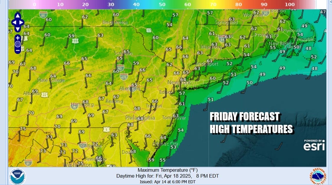
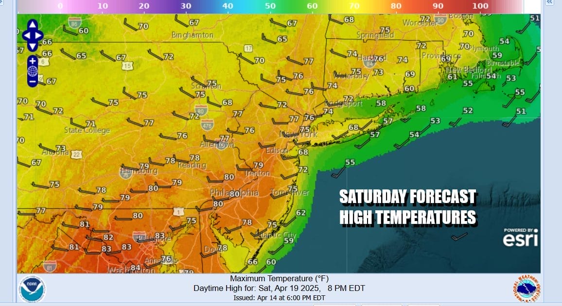
Friday looks to be no worse than partly sunny as a warm front goes by to our north. Other than perhaps a few clouds it should be a good day. Highs will reach the middle to upper 60s except about 10 degrees cooler along south and east facing shorelines. Saturday will be very warm with a west wind and sunshine much of the day. Highs Saturday will reach the mid 70s to some lower 80s. I’m going a little higher than weather models which is always a good idea this time of year.
An approaching cold front could set off a shower or thunderstorm but if it is weakening as it moves eastward, we will see slightly higher chances for storms inland and lower chances at the coast. Either way it leaves us with a dry but cooler Easter Sunday with sunshine across Eastern Pennsylvania to Southern New England. Highs Sunday afternoon will be mostly in the 60s.
BE SURE TO DOWNLOAD THE FREE METEOROLOGIST JOE CIOFFI WEATHER APP &
ANGRY BEN’S FREE WEATHER APP “THE ANGRY WEATHERMAN!
MANY THANKS TO TROPICAL TIDBITS FOR THE USE OF MAPS
Please note that with regards to any severe weather, tropical storms, or hurricanes, should a storm be threatening, please consult your local National Weather Service office or your local government officials about what action you should be taking to protect life and property.


