
Strong Thunderstorms Moving Across Central & South Jersey
Strong Thunderstorms Moving Across Central & South Jersey
The strong cold front is now moving across New Jersey and a line of showers and strong thunderstorms has developed and is moving eastward as shown by the satellite and radars. Severe Thunderstorm Warnings were up but the cells have weakened somewhat as they have moved eastward.
US SATELLITE

REGIONAL RADAR

LOCAL RADAR NEW YORK CITY

LOCAL RADAR PHILADELPHIA


To the north the thunderstorms are out North Jersey and the cells have weakened there as they move into the marine layer over NYC, the Hudson Valley and Long Island. Some heavy downpours will move through in the next few hours. Strong gusty winds behind the front will take over and a High Wind Warning is still in effect for Western New Jersey & Eastern Pennsylvania with some gusts to 50 mph possible.
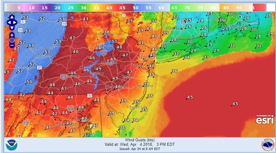
Wind advisories are posted elsewhere for gusts to 40 mph at times into this evening before winds diminish and skies clear overnight. Lows by morning will be in the mid 20s to lower 30s over most of the area. Thursday we will see sunshine with highs just in the 40s.
Friday morning brings a burst of snow around daybreak for a couple of hours that could leave a coating to an inch or so in areas north of Route 78 in New Jersey and Pennsylvania and the Hudson Valley. A stronger system arrives for Saturday and we will talk more about that later today once we see all the latest weather models regarding this.
 GET JOE A CIGAR IF YOU LIKE

FiOS1 News Weather Forecast For Long Island
FiOS1 News Weather Forecast For New Jersey
FiOS1 News Weather Forecast For Hudson Valley


