Strong Thunderstorms Moving Through
Strong Thunderstorms Moving Through
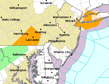
We are seeing a busy radar this evening as strong thunderstorms are moving through thanks to a cold front and temperatures ahead of it that climbed into the mid and upper 70s in many areas. Look for thunderstorms to continue into the evening before the front moves offshore. Some of these storms are accompanied strong gusty winds and heavy rains. Look for temperatures to fall into the 50s rather quickly once the front goes by.


There are Severe Thunderstorm and Special Marine Warnings in effect until these thunderstorms move on through.
TZ009-NJZ006-104-106>108-NYZ070>075-078-080-176>179-302115-
SOUTHERN FAIRFIELD-EASTERN UNION-EASTERN ESSEX-HUDSON-WESTERN
UNION-EASTERN BERGEN-BRONX-KINGS (BROOKLYN)-SOUTHERN
WESTCHESTER-NORTHERN WESTCHESTER-NEW YORK (MANHATTAN)-NORTHWEST
SUFFOLK-NORTHERN NASSAU-RICHMOND (STATEN IS.)-NORTHERN
QUEENS-SOUTHERN QUEENS-SOUTHERN NASSAU-SOUTHWEST SUFFOLK-
426 PM EDT SUN OCT 30 2016

...A LINE OF STRONG THUNDERSTORMS WILL AFFECT SOUTHERN FAIRFIELD...
UNION...SOUTHEASTERN ESSEX...SOUTHEASTERN BERGEN...HUDSON...NASSAU...
WESTERN SUFFOLK...KINGS...QUEENS...RICHMOND...SOUTH CENTRAL
WESTCHESTER...NEW YORK AND BRONX COUNTIES...

AT 425 PM EDT...RADAR INDICATED STRONG THUNDERSTORMS WERE LOCATED
ALONG A LINE EXTENDING FROM HARRISON TO CARDINAL SPELLMAN HS TO EAST
VILLAGE TO ELIZABETH. MOVEMENT WAS SOUTHEAST AT 35 MPH.

WIND GUSTS UP TO 50 MPH ARE POSSIBLE WITH THESE STORMS.

LOCATIONS IMPACTED INCLUDE...
NEW YORK...ISLIP...OYSTER BAY...NEWARK...JERSEY CITY...HUNTINGTON...
YONKERS...ELIZABETH...STAMFORD...NEW ROCHELLE...BAYONNE...WHITE
PLAINS...HOBOKEN...FREEPORT...LINDEN...VALLEY STREAM...LONG BEACH...
PORT CHESTER...LINDENHURST AND GLEN COVE.

TORRENTIAL RAINFALL IS ALSO OCCURRING WITH THESE STORMS.

FREQUENT CLOUD TO GROUND LIGHTNING IS OCCURRING WITH THIS STORM.
LIGHTNING CAN STRIKE 10 MILES AWAY FROM A THUNDERSTORM. SEEK A SAFE
SHELTER INSIDE A BUILDING OR VEHICLE.


* SEVERE THUNDERSTORM WARNING FOR...
  SOUTHEASTERN ADAMS COUNTY IN SOUTH CENTRAL PENNSYLVANIA...
  LEBANON COUNTY IN SOUTH CENTRAL PENNSYLVANIA...
  YORK COUNTY IN SOUTH CENTRAL PENNSYLVANIA...
  SOUTHEASTERN DAUPHIN COUNTY IN SOUTH CENTRAL PENNSYLVANIA...
  LANCASTER COUNTY IN SOUTH CENTRAL PENNSYLVANIA...

* UNTIL 530 PM EDT.

* AT 432 PM EDT...SEVERE THUNDERSTORMS WERE LOCATED ALONG A LINE
  EXTENDING FROM NEAR STRAUSSTOWN TO NEAR ELIZABETHTOWN TO NEAR
  EMMITSBURG...MOVING EAST AT 50 MPH.

  HAZARD...60 MPH WIND GUSTS.

  SOURCE...RADAR INDICATED.

  IMPACT...EXPECT DAMAGE TO ROOFS...SIDING...AND TREES.

* LOCATIONS IMPACTED INCLUDE...
  PALMYRA...WEIGELSTOWN...YORK...PARKVILLE...EAST PETERSBURG...RED
  LION...MOUNT JOY...EPHRATA...MYERSTOWN...LEBANON...MANHEIM...
  AKRON...CORNWALL...ANNVILLE...LITITZ...HANOVER...ELIZABETHTOWN...
  NEW HOLLAND...MILLERSVILLE AND WILLOW STREET.

THIS INCLUDES THE FOLLOWING INTERSTATES...
 THE PENNSYLVANIA TURNPIKE FROM MILE MARKERS 252 TO 295.
 INTERSTATE 78 FROM MILE MARKERS 7 TO 8.
 INTERSTATE 83 FROM MILE MARKERS 0 TO 32.

PRECAUTIONARY/PREPAREDNESS ACTIONS...

FOR YOUR PROTECTION MOVE TO AN INTERIOR ROOM ON THE LOWEST FLOOR OF A
BUILDING.
Weather conditions improve overnight and Monday though it will be cool on Halloween with sunshine and clouds and highs just into the 50s. Another warmup into midweek and another cold front with showers will arrive on Thursday
MANY THANKS TO TROPICAL TIDBITS FOR THE WONDERFUL USE OF THE MAPS
SNOW REMOVAL COMPANIES FOR YOUR WINTER NEEDS
LONG ISLAND ROCKLAND COUNTY Connecticut

![]()

FiOS1 News Weather Forecast For Long Island
FiOS1 News Weather Forecast For New Jersey
FiOS1 News Weather Forecast For Hudson Valley
NATIONAL WEATHER SERVICE SNOW FORECASTS
LATEST JOESTRADAMUS ON THE LONG RANGE

Weather App

Don’t be without Meteorologist Joe Cioffi’s weather app. It is really a meteorologist app because you get my forecasts and my analysis and not some automated computer generated forecast based on the GFS model. This is why your app forecast changes every 6 hours. It is model driven with no human input at all. It gives you an icon, a temperature and no insight whatsoever.
It is a complete weather app to suit your forecast needs. All the weather information you need is right on your phone. Android or I-phone, use it to keep track of all the latest weather information and forecasts. This weather app is also free of advertising so you don’t have to worry about security issues with your device. An accurate forecast and no worries that your device is being compromised.
Use it in conjunction with my website and my facebook and twitter and you have complete weather coverage of all the latest weather and the long range outlook. The website has been redone and upgraded. Its easy to use and everything is archived so you can see how well Joe does or doesn’t do when it comes to forecasts and outlooks.
Just click on the google play button or the apple store button on the sidebar for my app which is on My Weather Concierge. Download the app for free. Subscribe to my forecasts on an ad free environment for just 99 cents a month.
Get my forecasts in the palm of your hand for less than the cost of a cup of Joe!


