
Storm System Brings Showery Rains Friday Saturday Windy Colder Sunday

Storm System Brings Showery Rains Friday Saturday Windy Colder Sunday

We are looking ahead to a stormy weekend of rain and wind which would make it 7 straight weekends where we have seen rain on at least one day. However we also have another streak going and that is dry nice weather for Wednesday and Thursday as those two days during the week have seen little or no rain over the last couple of months. Such is the weather pattern we have been in. Today we are going to see sunshine and nothing more than some passing clouds. We still have what is left of the upper trough in the Eastern US but it is much weaker. Temperatures this afternoon will be in the low to mid 60s. Radars should be quiet today across Eastern Pennsylvania to Southern New England.
SATELLITE WITH LIGHTNING STRIKES

WEATHER RADAR

Skies should be clear tonight with most lows in the mid 40s to lower 50s. Thursday should be a very good day with sunshine most of the day, though clouds will start to arrive from west to east and from south to north as the day wears on. Highs Thursday will be in the mid 60s to around or just over 70 degrees in some places.

We are seeing lower than normal pressures in the Southeast US and just offshore and as the next cold front approaches from the west across the Great Lakes and Ohio Valley, low pressure will start to form in the Eastern Carolinas. Showery rains will develop with this lead low and those will move in during Friday morning. This first area will exit to the east Friday evening.

After those showers move out, there will be a short break and then a second stronger low develops in the Carolina mountains and moves northeast offshore. As the low reaches Southern New England during Saturday it will strengthen and bring rain to much of Eastern Pennsylvania to Southern New England. The low then moves into New England and the rains end Saturday night. Temperatures both Friday and Saturday will be in the 60s.
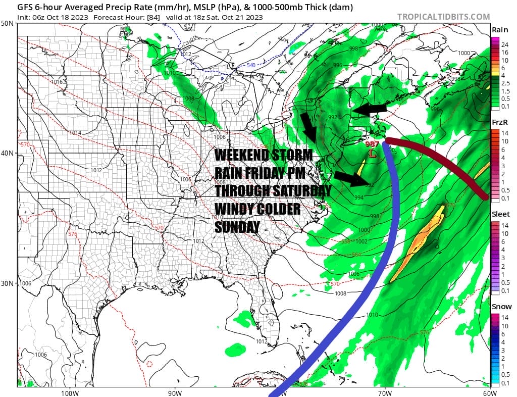
Sunday winds up being a “better” day if that is the word for it. The storm system will be in Northern New England and intensifying and that will create strong gusty winds during the day Sunday. We could see gusts of 30 or even 40 mph from the northwest. We will probably have a mix of sun and clouds for Sunday with highs just in the 50s. This is going to be a chilly air mass that is coming down for Sunday night and for the first few days of next week. It will however be dry and we will probably start to see the first frosts at night for areas inland.
BE SURE TO DOWNLOAD THE FREE METEOROLOGIST JOE CIOFFI WEATHER APP &
ANGRY BEN’S FREE WEATHER APP “THE ANGRY WEATHERMAN!
MANY THANKS TO TROPICAL TIDBITS FOR THE USE OF MAPS
Please note that with regards to any severe weather, tropical storms, or hurricanes, should a storm be threatening, please consult your local National Weather Service office or your local government officials about what action you should be taking to protect life and property.
(Amazon is an affilate of Meteorologist Joe Cioffi & earns commissions on sales.)


