Spring Weather Pattern Appears Active Long Range

Spring Weather Pattern Appears Active Long Range
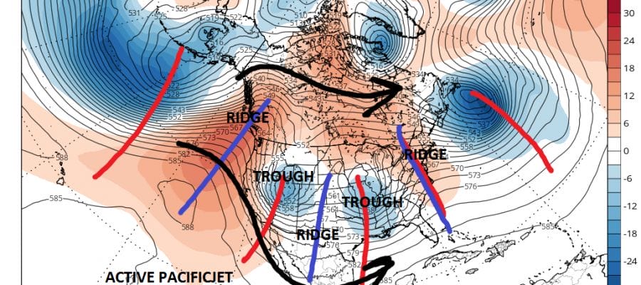
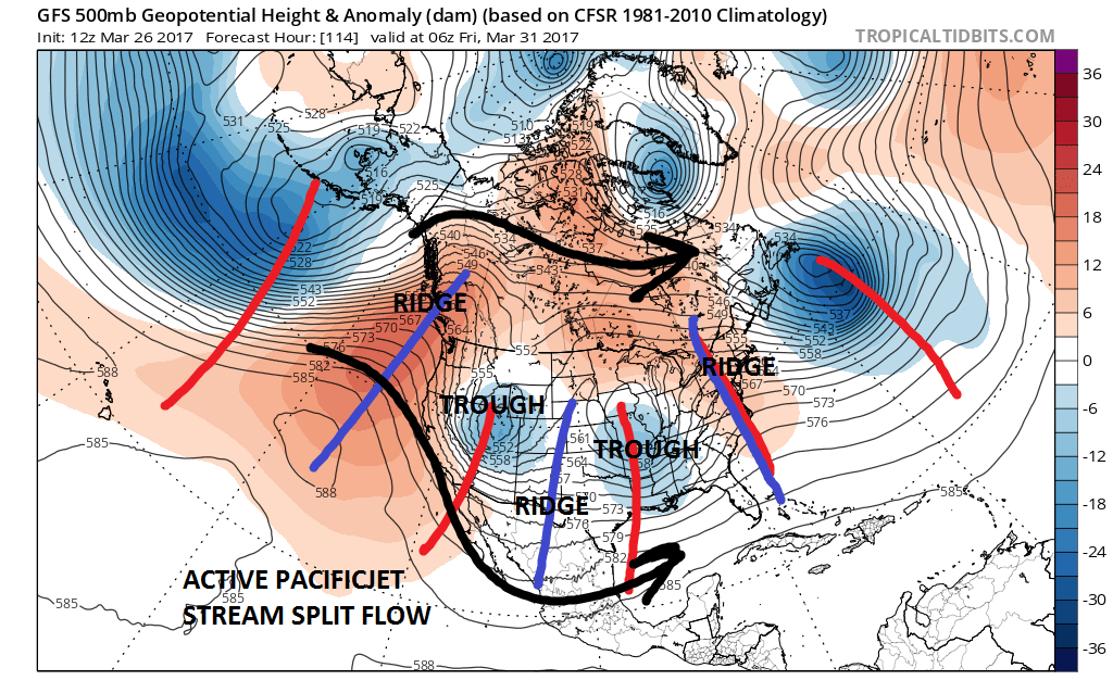
Unlike last Spring when we were coming off the super El Nino in the Pacific and the remnants of that pattern continued keeping things dry in much of the Northeast, it appears that we have a different weather pattern underway that looks very active with weather systems coming through every 2 to 3 days and the potential for some very valuable rainfall. Last Spring weather pattern was one of trough in the west ridge in the east and everything that came east would basically fall apart before it got here. The current upper air pattern is much busier characterized by an active Pacific jet stream pattern and basically a “split flow” across North America with one jet in Canada and the other across the Southern US.
SPRING WEATHER PATTERN UPPER AIR JET STREAM LATE THIS WEEK
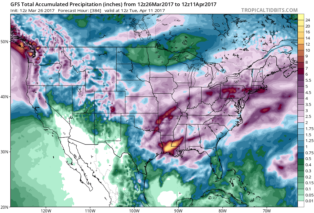
Without dealing with the specifics for the moment, a pattern like this would mean for ample rainfall over the next few weeks and all the weather models have the same general idea.
SPRING WEATHER PATTERN RAINFALL FORECAST NEXT 2 WEEKS
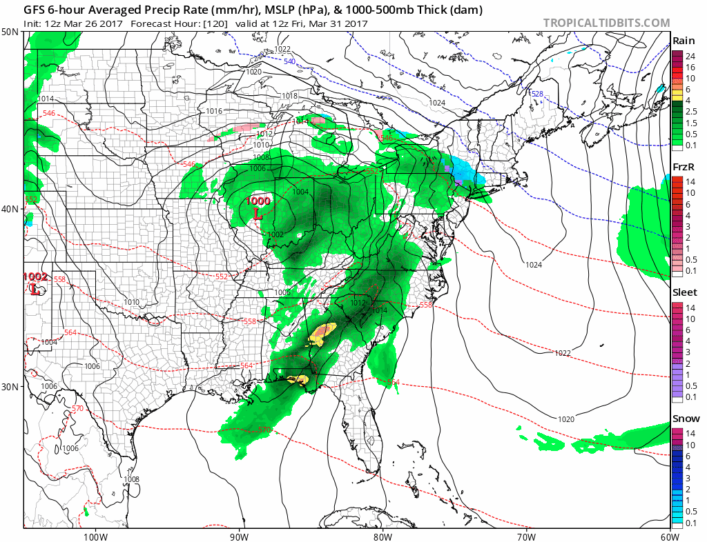
Now with regards to specifics both the GFS and the European model have a busy look this week with chances for rain Monday and Tuesday. Then we dry out for Wednesday and Thursday before we deal with more wet weather for Friday into Saturday as low pressure comes out of the Ohio Valley and passes by near or just to our south.
GFS SURFACE MAP FRIDAY INTO SATURDAY CLICK TO ANIMATE
Several weather systems follow this along in the coming weeks. It looks like more gray days are ahead of us than sunny ones but eventually we should see our fair share of nice days.
MANY THANKS TO TROPICAL TIDBITS FOR THE WONDERFUL USE OF THE MAPS

GET JOE A CIGAR IF YOU LIKE!
LANDSCAPE COMPANIES FOR YOUR SPRING SUMMER FALL NEEDS
LONG ISLAND ROCKLAND COUNTY Connecticut

![]()

ROCKLAND COUNTY TRI STATE SNOW REMOVAL JOHNSTOWN PA


FiOS1 News Weather Forecast For Long Island
FiOS1 News Weather Forecast For New Jersey
FiOS1 News Weather Forecast For Hudson Valley
NATIONAL WEATHER SERVICE SNOW FORECASTS
LATEST JOESTRADAMUS ON THE LONG RANGE
Weather App

Don’t be without Meteorologist Joe Cioffi’s weather app. It is really a meteorologist app because you get my forecasts and my analysis and not some automated computer generated forecast based on the GFS model. This is why your app forecast changes every 6 hours. It is model driven with no human input at all. It gives you an icon, a temperature and no insight whatsoever.
It is a complete weather app to suit your forecast needs. All the weather information you need is right on your phone. Android or I-phone, use it to keep track of all the latest weather information and forecasts. This weather app is also free of advertising so you don’t have to worry about security issues with your device. An accurate forecast and no worries that your device is being compromised.
Use it in conjunction with my website and my facebook and twitter and you have complete weather coverage of all the latest weather and the long range outlook. The website has been redone and upgraded. Its easy to use and everything is archived so you can see how well Joe does or doesn’t do when it comes to forecasts and outlooks.
Just click on the google play button or the apple store button on the sidebar for my app which is on My Weather Concierge. Download the app for free. Subscribe to my forecasts on an ad free environment for just 99 cents a month.
Get my forecasts in the palm of your hand for less than the cost of a cup of Joe!
![]()
