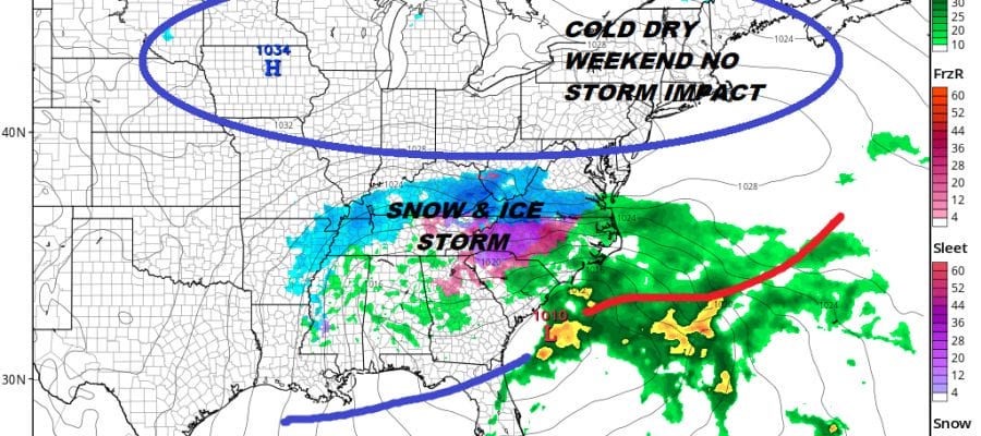
Southeast Snowstorm Gulf Coast Severe Weather Northeast Dry Cold Weekend
We are watching a storm that moved inland in California yesterday making its way across the Southern tier of the US. Low pressure will be developing along the Texas Gulf Coast and this sets up what will likely be a widespread snow and ice storm from parts of the Southern Plains eastward to the lower Tennessee Valley to the Southeast US. It is in the Southeast US that we think will see the worst of it as far as snow and ice is concerned. The Northern fringe of the accumulating snow line continues to shift southward as the cold air over the Great Lakes and Northeast becomes even more important. The potential for a foot or more of snow exists from the mountains of Northeast Georgia northeastward through the Carolinas to Southwest Virginia.
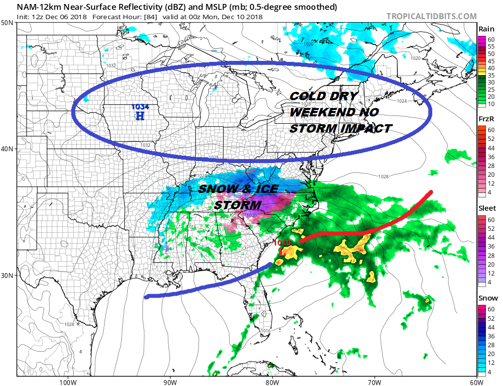
The cold dry high extending east west across the Great Lakes to New England will be anchored there all weekend. The northern part of the jet stream will continue to produce a cold northwest upper flow across New England down into the Northern Middle Atlantic States. This makes it impossible for that southern system to move up the East Coast. Instead we will have cold dry weather here into Monday with temperatures well below average.
EASTERN SATELLITE

REGIONAL RADAR

Today we have a cold front heading eastward and ahead of it we will see some sunshine and clouds. Radars are actually picking up on a few snow showers aloft and late this afternoon and this evening we could see some scattered snow showers around as the next cold air mass arrives. Temperatures today could reach 40 or even lower 40s before the front passes. Then we head lower tonight and set up for a cold Friday and weekend.
LOCAL RADAR NEW YORK CITY

LOCAL RADAR PHILADELPHIA

Friday Saturday and Sunday our forecast is quite easy. Look for sunshine and some passing clouds. Highs each day will be in the low to mid 30s and nighttime lows will be in the teens to lower 20s. Fireplaces and heaters will get a bit of a workout for sure. There is no impact from the southern storm here whatsoever. We could potentially be dry here through the end of next week and by then colder air will be retreating and a somewhat milder pattern takes over in the Eastern US.
MANY THANKS TO TROPICAL TIDBITS FOR THE USE OF MAPS
Please note that with regards to any tropical storms or hurricanes, should a storm be threatening, please consult your local National Weather Service office or your local government officials about what action you should be taking to protect life and property.